Geolocate

Luzon topographic map

Interactive map

Click on the map to display elevation.

About this map

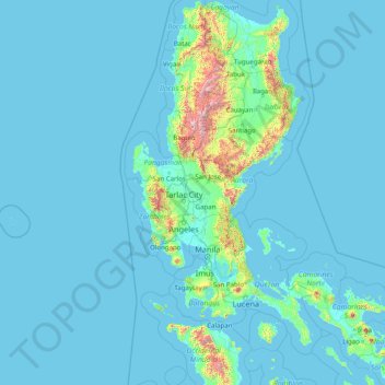
Name: Luzon topographic map, elevation, terrain.

Location: Luzon, Central Luzon, Philippines (12.53287 119.74983 18.65129 124.19838)

Average elevation: 289 ft

Minimum elevation: -3 ft

Maximum elevation: 9,049 ft

Other topographic maps

Click on a map to view its topography, its elevation and its terrain.

Mount Samat

Philippines > Bataan > Pilar

Average elevation: 955 ft

Quezon City

Philippines

Founded as a pueblo by Saint Pedro Bautista in 1590, San Francisco del Monte may be considered Quezon City's oldest district. The original land area of the old town of San Francisco del Monte was approximately2.5 square kilometres (1.0 sq mi) and covered parts of what is currently known as Project 7 and 8 and…

Average elevation: 187 ft

Cebu City

Philippines > Cebu > Cebu City

Average elevation: 459 ft

Bacolod

Philippines

Bacólod (English: Bacolod), is derived from bakólod (Old Spelling: bacólod), the Old Hiligaynon (Old Ilonggo) (Old Spelling: Ylongo and Ilongo) word for a "hill, turtle, mound, rise, hillock, down, any small eminence or elevation", since the resettlement was founded on a stony, hilly area, now the barangay…

Average elevation: 161 ft

Tayud

Philippines > Cebu

Average elevation: 30 ft

Cuaming

Philippines > Bohol > Inabanga

Average elevation: 0 ft

Baguilawa

Philippines > Batangas > Bauan

Average elevation: 430 ft

Sapang Uwak

Philippines > Pampanga > Porac

Average elevation: 823 ft

Maitim I

Philippines > Cavite > Amadeo

Average elevation: 1,742 ft

Mandaluyong

Philippines

Another claims that the Spaniards named the place based on the report of a navigator named Acapulco, who saw the rolling hills frequently being lashed at by daluyong (“big waves from the sea”). This seems to confirm traditional pre-Hispanic stories that giant waves from the sea would meet the adjoining…

Average elevation: 108 ft

Zamboanga City

Philippines > Zamboanga Peninsula > Zamboanga City

The overall topography of the city could be described as rolling to very steep. There are some flat lands, mostly narrow strips along the east coast. The urban center is mostly flat with a gentle slope to the interior, ranging from 0 to 3%. The highest registered elevation is 1,200 metres. In terms of slope, a…

Average elevation: 272 ft

Antipolo

Philippines > Rizal

Its higher elevation than that of Metro Manila affords it a scenic view of the metropolis, especially at night. Its locally grown mangoes and cashews are popular among tourists, as well as suman – a local delicacy made out of glutinous rice. The Hinulugang Taktak National Park, which was once a popular…

Average elevation: 410 ft

San Juan

Philippines

"San Juan" is a contraction of the city's traditional name of "San Juan del Monte" (lit. 'Saint John of the Mountain'). As with numerous other places in the Philippines, the name combines a patron saint and a toponym; in this case Saint John the Baptist with the locale's hilly terrain and relatively higher…

Average elevation: 115 ft

Tanay

Philippines > Rizal

Average elevation: 105 ft

Villaflorida

Philippines > Camarines Sur > Ocampo

Average elevation: 1,145 ft

Aberawan

Philippines > Palawan > El Nido

Average elevation: 121 ft

Masinloc

Philippines > Zambales

Average elevation: 43 ft

Calibato Lake

Philippines > Laguna > San Pablo > Santo Angel

Average elevation: 761 ft

East Dirita

Philippines > Zambales > San Antonio

Average elevation: 49 ft

Biga

Philippines > Batangas > Calatagan

Average elevation: 148 ft

Macalva

Philippines > La Union > Agoo

Average elevation: 256 ft

Buho

Philippines > Cavite > Silang

Average elevation: 1,759 ft

Pasay

Philippines

Average elevation: 46 ft

Rizal

Philippines > Quirino > Rizal

Average elevation: 427 ft

Santa Rosa

Philippines > Laguna > Santa Rosa

Average elevation: 213 ft

Bacoor

Philippines > Cavite

Average elevation: 59 ft

Solong

Philippines > Catanduanes > San Miguel

Average elevation: 676 ft

Matangtubig

Philippines > Bulacan > Baliwag

Average elevation: 39 ft

Carmen

Philippines > Cebu

Average elevation: 194 ft

Malumpati Cold Spring

Philippines > Antique > Pandan > Buang > Santa Cruz

Average elevation: 236 ft

Ramirez

Philippines > Cavite > Magallanes

Average elevation: 623 ft

Malainen Luma

Philippines > Cavite > Naic

Average elevation: 177 ft

Santa Cruz

Philippines > Ilocos Sur

Average elevation: 49 ft

Summit

Philippines > Quezon > Atimonan > San Rafael

Average elevation: 167 ft

Diat

Philippines > Davao de Oro > Pantukan

Average elevation: 2,713 ft

Sumilon

Philippines > Surigao Del Norte

Average elevation: 3 ft

Mount Bonbon

Philippines > Palawan > Magsaysay

Average elevation: 128 ft

Upa

Philippines > Batangas > Mataasnakahoy

Average elevation: 1,017 ft

San Fernando

Philippines > Pampanga

Average elevation: 79 ft

Malolos

Philippines > Bulacan

Malolos is relatively flat of about 0.81% to a gently sloping of 2.17%. The slope of the land descends towards west, southwest to southern direction. The highest land elevation is at about 6.0 meters above sea level while the lowest is only half a meter below sea level. A network of natural waterways and…

Average elevation: 20 ft

Tagaytay

Philippines > Cavite

The southern and eastern portions of Tagaytay are covered by hills and mountains which is generally forests, pine trees and open grasslands. The city lies along Tagaytay Ridge, a ridge stretching about 32 kilometres (20 mi) from Mount Batulao in the west to Mount Sungay in the east with elevations averaging…

Average elevation: 751 ft

Iligan

Philippines

Average elevation: 751 ft

Calumpit

Philippines > Bulacan > Calumpit

Average elevation: 13 ft

Alfonso

Philippines > Cavite > Alfonso

Average elevation: 1,355 ft

Crossing Diamond

Philippines > Davao City > Datu Salumay

Average elevation: 3,655 ft

Dinagsaan Peak

Philippines > Davao Oriental > Banaybanay > Pintatagan > Looc

Average elevation: 951 ft

Cuayang Bugtong

Philippines > Pampanga > Candaba

Average elevation: 36 ft

Maislap

Philippines > Rizal > Montalban

Average elevation: 269 ft

Buenavista

Philippines > Quezon

Average elevation: 217 ft

San Agustin

Philippines > Cavite > Trece Martires

Average elevation: 361 ft

Balijuagan

Philippines > Capiz > Roxas

Average elevation: 79 ft

Sugpon

Philippines > Ilocos Sur

Average elevation: 728 ft

Dinginan

Philippines > Capiz > Roxas

Average elevation: 121 ft

Guinsang-an

Philippines > South Cotabato > Santo Niño

Average elevation: 387 ft

Sacsac

Philippines > Cebu > Consolacion

Average elevation: 269 ft

Bancalan Island

Philippines > Palawan > Balabac

Average elevation: 20 ft

O'Donnell

Philippines > Tarlac > Capas

Average elevation: 420 ft

Corus

Philippines > Benguet > La Trinidad > Bineng

Average elevation: 3,481 ft

Malabang

Philippines > Lanao del Sur

Average elevation: 121 ft

Planza

Philippines > Camarines Sur

Average elevation: 66 ft

Tuburan

Philippines > Cebu

Average elevation: 157 ft

Tunasan River

Philippines > Muntinlupa

Average elevation: 154 ft

Naga

Philippines > Cebu

Average elevation: 335 ft

Tamacan

Philippines > Cavite > Amadeo

Average elevation: 961 ft

Bagong Silang

Philippines > Isabela > Ilagan

Average elevation: 184 ft

San Jose de Buan

Philippines > Samar

Average elevation: 981 ft

Townsite

Philippines > Bataan > Limay

Average elevation: 66 ft

Camarag

Philippines > Isabela

Average elevation: 236 ft

Lumondao

Philippines > Davao City

Average elevation: 1,601 ft

Energy Park

Philippines > Davao del Norte > Tagum

Average elevation: 59 ft

Patong-patong

Philippines > Iloilo

Average elevation: 348 ft

San Martin

Philippines > Bukidnon > Malaybalay

Average elevation: 1,266 ft

Gatbuca

Philippines > Bulacan > Calumpit

Average elevation: 16 ft

Montay

Philippines > North Cotabato > Libungan

Average elevation: 217 ft

Gapok

Philippines > Sultan Kudarat > Senator Ninoy Aquino

Average elevation: 2,306 ft

Caloocan

Philippines > Caloocan > Caloocan

Average elevation: 62 ft

Ilawod

Philippines > Camarines Sur > Caramoan

Average elevation: 210 ft

Kuya

Philippines > Bukidnon > Maramag

Average elevation: 2,238 ft

Nauring

Philippines > Antique > Pandan

Average elevation: 39 ft

Luciano

Philippines > Cavite > Trece Martires

Average elevation: 413 ft

Dugmanon

Philippines > Davao Oriental > San Isidro

Average elevation: 417 ft

Mainit

Philippines > Leyte > Alangalang > Binungto-an

Average elevation: 131 ft

Samal Island

Philippines > Davao del Norte > Samal

Average elevation: 384 ft

Purok 3

Philippines > Samar > Santa Margarita > Burabod

Average elevation: 43 ft

Punta Tabuc

Philippines > Capiz > Roxas

Average elevation: 16 ft

Embarcadero

Philippines > Pangasinan > Mangaldan

Average elevation: 23 ft

Tatawiran

Philippines > Quezon > General Nakar

Average elevation: 2,024 ft

Dalicanan

Philippines > Iloilo

Average elevation: 430 ft

San Antonio

Philippines > Albay > Tabaco

Average elevation: 240 ft

Cainta

Philippines > Rizal

Average elevation: 79 ft

San Narciso

Philippines > Zambales

San Narciso is located in a relatively flat plain. West of the town is the South China Sea and to the east is bordered by the Sto. Tomas river are the Zambales Mountain Ranges. Average elevation is 3.6 metres (12 ft) above sea level and the highest elevation is 800 metres (2,600 ft) above sea level.

Average elevation: 36 ft

Bagabag

Philippines > Nueva Vizcaya

Average elevation: 860 ft

Butuan

Philippines

Average elevation: 377 ft

Amadeo

Philippines > Cavite > Amadeo

Average elevation: 1,385 ft

Dalwangan

Philippines > Bukidnon > Malaybalay

Average elevation: 2,927 ft

Nagas

Philippines > Albay

Average elevation: 105 ft

Raradangan

Philippines > North Cotabato > Alamada

Average elevation: 768 ft

Butig

Philippines > Lanao del Sur

Average elevation: 2,644 ft

Lapu-Lapu

Philippines

Average elevation: 305 ft