
Lycoming County topographic map
Interactive map
Click on the map to display elevation.
About this map
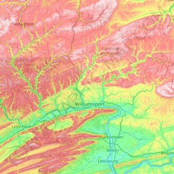
Name: Lycoming County topographic map, elevation, terrain.
Location: Lycoming County, Pennsylvania, United States (41.06871 -77.59927 41.59668 -76.44770)
Average elevation: 1,362 ft
Minimum elevation: 417 ft
Maximum elevation: 2,556 ft
Other topographic maps
Click on a map to view its topography, its elevation and its terrain.
Pittsburgh
United States > Pennsylvania > Allegheny County
Pittsburgh, Allegheny County, Pennsylvania, United States
Average elevation: 994 ft
Philadelphia
United States > Pennsylvania > Philadelphia County
Philadelphia, Philadelphia County, Pennsylvania, United States
Average elevation: 144 ft
Mount Pocono
United States > Pennsylvania > Monroe County
Mount Pocono, Monroe County, Pennsylvania, 18344, United States
Average elevation: 1,762 ft
Rosemount
United States > Pennsylvania > York County > Spring Garden Township
Rosemount, Spring Garden Township, York County, Pennsylvania, 17405, United States
Average elevation: 548 ft
Export
United States > Pennsylvania > Westmoreland County
Export, Westmoreland County, Pennsylvania, 15632, United States
Average elevation: 1,122 ft
State College
United States > Pennsylvania > Centre County
State College, Centre County, Pennsylvania, United States
Average elevation: 1,152 ft
Gettysburg
United States > Pennsylvania > Adams County
Gettysburg, Adams County, Pennsylvania, 17325, United States
Average elevation: 528 ft
Easton
United States > Pennsylvania > Northampton County
Easton, Northampton County, Pennsylvania, United States
Average elevation: 358 ft
Adams County
Adams County, Pennsylvania, United States
Average elevation: 820 ft
Ringtown
United States > Pennsylvania > Schuylkill County
Ringtown, Schuylkill County, Pennsylvania, United States
Average elevation: 1,112 ft
Chester County
Chester County, Pennsylvania, United States
Average elevation: 407 ft
Wilmot Township
United States > Pennsylvania > Bradford County
Wilmot Township, Bradford County, Pennsylvania, 18846, United States
Average elevation: 1,227 ft
Monroe County
Monroe County, Pennsylvania, United States
Average elevation: 1,184 ft
Indiana County
Indiana County, Pennsylvania, United States
Average elevation: 1,440 ft
Hometown
United States > Pennsylvania > Schuylkill County > Rush Township
Hometown, Rush Township, Schuylkill County, Pennsylvania, United States
Average elevation: 1,155 ft
East Stroudsburg
United States > Pennsylvania > Monroe County
East Stroudsburg, Monroe County, Pennsylvania, 18301, United States
Average elevation: 499 ft
Aldan
United States > Pennsylvania > Delaware County
Aldan, Delaware County, Pennsylvania, United States
Average elevation: 125 ft
East Texas
United States > Pennsylvania > Lehigh County > Lower Macungie Township
East Texas, Lower Macungie Township, Lehigh County, Pennsylvania, 18046, United States
Average elevation: 413 ft
Somerset
United States > Pennsylvania > Somerset County
Somerset, Somerset County, Pennsylvania, United States
Average elevation: 2,172 ft
Lewisburg
United States > Pennsylvania > Union County
Lewisburg, Union County, Pennsylvania, United States
Average elevation: 466 ft
Hamiltonban Township
United States > Pennsylvania > Adams County
Hamiltonban Township, Adams County, Pennsylvania, 17261, United States
Average elevation: 1,053 ft
Barnett Township
United States > Pennsylvania > Forest County
Barnett Township, Forest County, Pennsylvania, 16217, United States
Average elevation: 1,526 ft
Abbott Township
United States > Pennsylvania > Potter County
Abbott Township, Potter County, Pennsylvania, United States
Average elevation: 1,975 ft
Pine Township
United States > Pennsylvania > Clearfield County
Pine Township, Clearfield County, Pennsylvania, United States
Average elevation: 2,093 ft
Mount Pleasant Township
United States > Pennsylvania > Adams County
Mount Pleasant Township, Adams County, Pennsylvania, United States
Average elevation: 558 ft
Allegheny County
Allegheny County, Pennsylvania, United States
Average elevation: 1,066 ft
Hershey
United States > Pennsylvania > Dauphin County
Hershey, Dauphin County, Pennsylvania, 17033, United States
Average elevation: 443 ft
Scranton
United States > Pennsylvania > Lackawanna County
Scranton, Lackawanna County, Pennsylvania, United States
Average elevation: 1,181 ft
Harrisburg
United States > Pennsylvania > Dauphin County
Harrisburg, Dauphin County, Pennsylvania, United States
Average elevation: 400 ft
Spring Creek Township
United States > Pennsylvania > Elk County
Spring Creek Township, Elk County, Pennsylvania, United States
Average elevation: 1,677 ft
Cress Ridge
United States > Pennsylvania > Adams County > Mount Pleasant Township
Cress Ridge, Mount Pleasant Township, Adams County, Pennsylvania, United States
Average elevation: 581 ft
Conestoga
United States > Pennsylvania > Lancaster County > Conestoga Township
Conestoga, Conestoga Township, Lancaster County, Pennsylvania, 17516, United States
Average elevation: 387 ft
West Chester
United States > Pennsylvania > Chester County
West Chester, Chester County, Pennsylvania, 19383, United States
Average elevation: 413 ft
Cranberry Township
United States > Pennsylvania > Butler County
Cranberry Township, Butler County, Pennsylvania, 16066, United States
Average elevation: 1,119 ft
York County
York County, Pennsylvania, United States
Average elevation: 558 ft
Hatfield Borough
United States > Pennsylvania > Montgomery County
Hatfield Borough, Montgomery County, Pennsylvania, United States
Average elevation: 338 ft
Ambridge Heights
United States > Pennsylvania > Beaver County
Ambridge Heights, Harmony Township, Beaver County, Pennsylvania, 15003, United States
Average elevation: 912 ft
Rockwood
United States > Pennsylvania > Somerset County
Rockwood, Somerset County, Pennsylvania, United States
Average elevation: 1,978 ft
Fulmor
United States > Pennsylvania > Montgomery County > Upper Moreland Township
Fulmor, Upper Moreland Township, Montgomery County, Pennsylvania, 19040, United States
Average elevation: 259 ft
Ohio River Headwaters and Hydrological Headwaters of the Mississippi River
United States > Pennsylvania > Potter County > Allegany Township
Ohio River Headwaters and Hydrological Headwaters of the Mississippi River, Ben Green Road, Allegany Township, Potter County, Pennsylvania, United States
Average elevation: 2,454 ft
Phoenixville
United States > Pennsylvania > Chester County
Phoenixville, Chester County, Pennsylvania, United States
Average elevation: 180 ft
Altoona
United States > Pennsylvania > Blair County
Altoona, Blair County, Pennsylvania, United States
Average elevation: 1,453 ft
Jenner Township
United States > Pennsylvania > Somerset County
Jenner Township, Somerset County, Pennsylvania, United States
Average elevation: 2,044 ft
Nashua
United States > Pennsylvania > Lawrence County > Pulaski Township
Nashua, Pulaski Township, Lawrence County, Pennsylvania, United States
Average elevation: 938 ft
Dingmans Ferry
United States > Pennsylvania > Pike County > Delaware Township
Dingmans Ferry, Delaware Township, Pike County, Pennsylvania, 07851, United States
Average elevation: 630 ft
Green Lane
United States > Pennsylvania > Montgomery County
Green Lane, Montgomery County, Pennsylvania, United States
Average elevation: 318 ft
Salina
United States > Pennsylvania > Westmoreland County > Bell Township
Salina, Bell Township, Westmoreland County, Pennsylvania, 15680, United States
Average elevation: 1,093 ft
Dauphin County
Dauphin County, Pennsylvania, United States
Average elevation: 643 ft
East Allentown
United States > Pennsylvania > Lehigh County > Allentown
East Allentown, Allentown, Lehigh County, Pennsylvania, United States
Average elevation: 371 ft
Jackson Township
United States > Pennsylvania > Lebanon County
Jackson Township, Lebanon County, Pennsylvania, 17067, United States
Average elevation: 518 ft