
Make a donation
Gear up for your next adventure:
As an Amazon Associate, this site earns from qualifying purchases at no extra cost to you.
East Stroudsburg topographic map
Click on the map to display elevation.
Make a donation
Gear up for your next adventure:
As an Amazon Associate, this site earns from qualifying purchases at no extra cost to you.
East Stroudsburg
Stroudsburg-Pocono Airport is located near East Stroudsburg, in Smithfield Township, Monroe County, Pennsylvania. Stroudsburg-Pocono Airport serves East Stroudsburg and Monroe County and is owned by Robert Strenz. The paved runway extends for 3087 feet. The facility is at an elevation of 480 feet. The airport offers activities such as the Sky's the Limit Skydiving Center and a golf driving range.
Make a donation
Gear up for your next adventure:
As an Amazon Associate, this site earns from qualifying purchases at no extra cost to you.
About this map
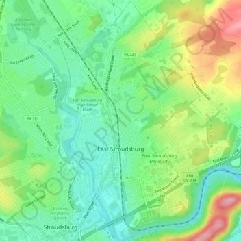
Name: East Stroudsburg topographic map, elevation, terrain.
Average elevation: 499 ft
Minimum elevation: 335 ft
Maximum elevation: 794 ft
Monroe County trails, hiking, mountain biking, running and outdoor activities
Make a donation
Gear up for your next adventure:
As an Amazon Associate, this site earns from qualifying purchases at no extra cost to you.
Other topographic maps
Click on a map to view its topography, its elevation and its terrain.
Long Pond
United States > Pennsylvania > Monroe County > Tunkhannock Township
Long Pond is named after the unique wetland topography formed by the Tunkhannock Creek. Within the Long Pond community, public access lands are owned and protected by The Bethlehem Authority, Nature Conservancy, Wildlands Conservancy County of Monroe Open Space Program, , PA Game Commission and PA Department…
Average elevation: 1,873 ft
Mount Nebo Park
United States > Pennsylvania > Monroe County > East Stroudsburg > Twin Falls
Average elevation: 607 ft
Tobyhanna
United States > Pennsylvania > Monroe County > Coolbaugh Township
Average elevation: 1,936 ft
Skytop
United States > Pennsylvania > Monroe County > Barrett Township
Skytop is an unincorporated community in Barrett Township, Monroe County, Pennsylvania, United States. Located north of Mountainhome, it is accessible by local roads off Route 390. Its elevation is 1,562 feet (476 m), and it is located at 41°13′40″N 75°14′18″W / 41.22778°N 75.23833°W /…
Average elevation: 1,539 ft
Make a donation
Gear up for your next adventure:
As an Amazon Associate, this site earns from qualifying purchases at no extra cost to you.
Blue Mountain
United States > Pennsylvania > Monroe County > Eldred Township
The ridge of Blue Mountain runs for 150 miles (240 km) through Pennsylvania, reaching an elevation of 2,270 feet (690 m) above sea level just north of the Pennsylvania Turnpike, near the borough of Newburg. Most of the ridgecrest, however, only reaches between 1,400 and 1,700 feet (430 and 520 m) in elevation.…
Average elevation: 794 ft
Pocono Lake
United States > Pennsylvania > Monroe County > Tobyhanna Township
Average elevation: 1,781 ft
Tannersville
United States > Pennsylvania > Monroe County > Pocono Township
Average elevation: 1,037 ft
Kunkletown
United States > Pennsylvania > Monroe County > Eldred Township
Kunkletown is an unincorporated community in Eldred Township, Monroe County, Pennsylvania, United States. It is located at an elevation of 531 feet. It is at ZIP Code 18058.
Average elevation: 735 ft
Make a donation
Gear up for your next adventure:
As an Amazon Associate, this site earns from qualifying purchases at no extra cost to you.
Blakeslee
United States > Pennsylvania > Monroe County > Tobyhanna Township
Average elevation: 1,654 ft
Canadensis
United States > Pennsylvania > Monroe County > Barrett Township
Average elevation: 1,207 ft
Make a donation
Gear up for your next adventure:
As an Amazon Associate, this site earns from qualifying purchases at no extra cost to you.
Gilbert
United States > Pennsylvania > Monroe County > Chestnuthill Township
Average elevation: 794 ft
Marshalls Creek
United States > Pennsylvania > Monroe County > Smithfield Township
Average elevation: 610 ft
Make a donation
Gear up for your next adventure:
As an Amazon Associate, this site earns from qualifying purchases at no extra cost to you.
Pocono Summit
United States > Pennsylvania > Monroe County > Tobyhanna Township
Average elevation: 1,795 ft
Shawnee on Delaware
United States > Pennsylvania > Monroe County > Smithfield Township
Average elevation: 617 ft
Make a donation
Gear up for your next adventure:
As an Amazon Associate, this site earns from qualifying purchases at no extra cost to you.
Long Pond
United States > Pennsylvania > Monroe County > Tunkhannock Township
Long Pond is named after the wetland topography formed by Tunkhannock Creek. Within the Long Pond community are public access lands, containing many species of plants and animals. Long Pond has been called "the most unique inland freshwater wetland in the state".
Average elevation: 1,873 ft
Camelback Mountain
United States > Pennsylvania > Monroe County > Jackson Township
Average elevation: 1,503 ft
Gilbert
United States > Pennsylvania > Monroe County > Chestnuthill Township
Average elevation: 794 ft
Make a donation
Gear up for your next adventure:
As an Amazon Associate, this site earns from qualifying purchases at no extra cost to you.
Pocono Lake
United States > Pennsylvania > Monroe County > Tobyhanna Township
Average elevation: 1,781 ft
Pocono Manor
United States > Pennsylvania > Monroe County > Pocono Township
Average elevation: 1,594 ft
Long Pond
United States > Pennsylvania > Monroe County > Tunkhannock Township
Long Pond is named after the wetland topography formed by Tunkhannock Creek. Within the Long Pond community are public access lands, containing many species of plants and animals. Long Pond has been called "the most unique inland freshwater wetland in the state".
Average elevation: 1,873 ft
Tobyhanna
United States > Pennsylvania > Monroe County > Coolbaugh Township
Average elevation: 1,936 ft
Make a donation
Gear up for your next adventure:
As an Amazon Associate, this site earns from qualifying purchases at no extra cost to you.
Blakeslee
United States > Pennsylvania > Monroe County > Tobyhanna Township
Average elevation: 1,654 ft