
Carrara topographic map
Interactive map
Click on the map to display elevation.
About this map
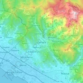
Name: Carrara topographic map, elevation, terrain.
Location: Carrara, Massa-Carrara, Tuscany, 54033, Italy (44.02666 10.01876 44.12975 10.17111)
Average elevation: 1,237 ft
Minimum elevation: -3 ft
Maximum elevation: 5,627 ft
Other topographic maps
Click on a map to view its topography, its elevation and its terrain.
Lamole
Italy > Tuscany > Metropolitan City of Florence > Greve in Chianti > Lamole
Average elevation: 1,886 ft
Castello di Lamole
Italy > Tuscany > Metropolitan City of Florence > Greve in Chianti > Castello di Lamole
Average elevation: 1,929 ft
Lari
Lari is a walled mountaintop frazione, or hamlet, in the comune of Casciana Terme Lari, 60 kilometres (37 mi) southwest of Florence and 25 kilometres (16 mi) southeast of Pisa, in the Tuscany region of Italy. The municipal seat of its comune, Lari dates from at least the 9th century BC, a fact established by…
Average elevation: 262 ft
Borro Bologna
Italy > Tuscany > Metropolitan City of Florence > Reggello > San Giovenale
Average elevation: 1,145 ft