
Carson City topographic map
Interactive map
Click on the map to display elevation.
Carson City
Most of the city proper resides in the Eagle Valley. The Carson River flows from Douglas County through the southwestern edge of both the valley and Carson City. Since the consolidation, the city limits today include several small populated areas outside of this valley. Today the city limits include several peaks in the Sierra Nevada, small portions of both the Virginia Range and the Pine Nut Mountains and portions of Marlette Lake and Lake Tahoe. The highest elevation in city limits is Snow Valley Peak at an elevation of 9,214 feet (2,808 m). Carson City is one of two state capitals that border another state, the other being Trenton, New Jersey.
About this map
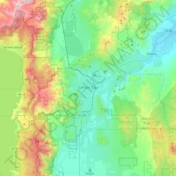
Name: Carson City topographic map, elevation, terrain.
Location: Carson City, Nevada, United States (39.08480 -120.00449 39.25087 -119.54831)
Average elevation: 5,988 ft
Minimum elevation: 4,298 ft
Maximum elevation: 10,725 ft
Nevada trails, hiking, mountain biking, running and outdoor activities
Other topographic maps
Click on a map to view its topography, its elevation and its terrain.
Jackpot
United States > Nevada > Elko County
In addition to its casino industry, Jackpot has its own schools, golf course, and post office. Its elevation is approximately 5,200 feet (1,580 m) above sea level.
Average elevation: 5,364 ft
Hiko
United States > Nevada > Lincoln County
The Hiko and Crystal Springs provide a large supply of water for the Hiko farms and ranches. The Hiko farming community is located in the north end of the Pahranagat Valley and lies at an elevation of 3,869 feet (1,179 m), with a ZIP code of 89017.
Average elevation: 4,045 ft
McDermitt
United States > Nevada > Humboldt County
The community is on U.S. Highway 95, 73 miles (117 km) north of Winnemucca. The elevation of McDermitt is 4,432 feet (1,351 m) above sea level.
Average elevation: 4,459 ft
Austin
United States > Nevada > Lander County
Austin is an unincorporated small town in, and former county seat of, Lander County, Nevada, United States. In 2020, the census-designated place of Austin had a population of 167. It is located on the western slopes of the Toiyabe Range at an elevation of 6,575 feet (2,004 m). U.S. Route 50 passes through the…
Average elevation: 6,811 ft
Great Basin
United States > Nevada > Eureka County
The Great Basin is the largest area of contiguous endorheic watersheds, those with no outlets, in North America. It spans nearly all of Nevada, much of Utah, and portions of California, Idaho, Oregon, Wyoming, and Baja California. It is noted for both its arid climate and the basin and range topography that…
Average elevation: 6,293 ft
Walker Lake
United States > Nevada > Mineral County > Schurz
These diversions have resulted in a severe drop in the lake's level. According to the USGS, the level dropped approximately 181 ft (55 m) between 1882 and 2016. By June 2016, the lake level was 3,909 feet (1,191 m) above sea level, the lowest lake elevation since measurement began in 1882. As of 2022, Walker…
Average elevation: 5,023 ft
Mercury
United States > Nevada > Nye County
In 1957, the US Navy launched nine atmospheric sounding rockets to measure nuclear radiation and other atmospheric data, using Mercury as a staging area. The Naval Radiological Defense Laboratory conducted its first test flight in 1956. This test rocket lifted 13.6 kilograms (30 lb) to an altitude of 40…
Average elevation: 3,881 ft
Oxbow Nature Study Area
United States > Nevada > Washoe County > Reno > West Reno
Average elevation: 4,642 ft
Winnemucca
United States > Nevada > Humboldt County > Winnemucca > Winnemucca
Average elevation: 4,603 ft