
Cleveland County topographic map
Interactive map
Click on the map to display elevation.
About this map
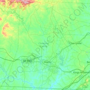
Name: Cleveland County topographic map, elevation, terrain.
Location: Cleveland County, North Carolina, United States (35.16348 -81.76810 35.58458 -81.32173)
Average elevation: 968 ft
Minimum elevation: 587 ft
Maximum elevation: 2,851 ft
North Carolina trails, hiking, mountain biking, running and outdoor activities
Other topographic maps
Click on a map to view its topography, its elevation and its terrain.
Appalachian Mountains
United States > North Carolina > Yancey County
The Appalachian Mountains (French: Appalaches), often called the Appalachians, are a system of mountains in eastern to northeastern North America. The Appalachians first formed roughly 480 million years ago during the Ordovician Period. They once reached elevations similar to those of the Alps and the Rocky…
Average elevation: 4,800 ft
Highlands
United States > North Carolina > Macon County > Highlands
Highlands was founded in 1875 after its two founders, Samuel Truman Kelsey and Clinton Carter Hutchinson, drew lines from Chicago to Savannah and from New Orleans to New York City. They felt that the place where these lines met would eventually become a great trading center and commercial crossroads. Highlands…
Average elevation: 3,576 ft
Mount Mitchell
United States > North Carolina > Yancey County
Mount Mitchell, known in Cherokee as Attakulla, is the highest peak of the Appalachian Mountains and the highest peak in mainland eastern North America. It is located near Burnsville in Yancey County, North Carolina in the Black Mountain subrange of the Appalachians about 19 miles (31 km) northeast of…
Average elevation: 5,719 ft
Spring Valley
United States > North Carolina > Mecklenburg County > Charlotte
Average elevation: 659 ft
Providence Plantation
United States > North Carolina > Mecklenburg County > Charlotte
Average elevation: 673 ft
Rich Mountain
United States > North Carolina > Watauga County
Rich Mountain is a mountain located in the North Carolina High Country, roughly 3 miles (4.8 km) northwest of the town of Boone. Its elevation reaches 4,748 feet (1,447 m).
Average elevation: 3,983 ft
Stone Mountain
United States > North Carolina > Wilkes County
Stone Mountain is the centerpiece of Stone Mountain State Park in North Carolina. It is a dome of exposed granite (specifically a quartz diorite to granodiorite) of Devonian age, which has intruded into the gneiss of the Precambrian Alligator Back Formation. It rises sharply over 600 feet (183 m) above the…
Average elevation: 1,860 ft
Bald Head Island
United States > North Carolina > Brunswick County > Bald Head Island
Average elevation: 10 ft
Parmele Isles
United States > North Carolina > New Hanover County > Wrightsville Beach
Average elevation: 3 ft
Reynolda Village
United States > North Carolina > Forsyth County > Winston-Salem
Average elevation: 912 ft
Wolf Creek Lake
United States > North Carolina > Jackson County > Wolf Mountain
Average elevation: 3,350 ft
Arden
United States > North Carolina > Buncombe County > Asheville > Royal Pines
Average elevation: 2,274 ft
Haw Creek Park
United States > North Carolina > Buncombe County > Asheville > Dogwood Grove
Average elevation: 2,185 ft
Swan Quarter
United States > North Carolina > Hyde County
Swan Quarter is in western Hyde County at latitude 35.405 N and longitude 76.331 W. The elevation is 3 feet (0.91 m) above sea level. It is located on Swanquarter Bay, an inlet of Pamlico Sound.
Average elevation: 7 ft