
Jefferson County topographic map
Interactive map
Click on the map to display elevation.
Jefferson County
Jefferson County showcases a varied and dynamic topography characterized by its location within the Ridge-and-Valley Appalachian region. The county's terrain features rolling hills and valleys, which rise and fall gently across its landscape. The average elevation in the county hovers around 568 feet, with some peaks reaching upwards of 1,000 feet. Notably, Shades Mountain, one of the highest points, offers scenic views and contributes to the area's rugged beauty. Additionally, the region includes numerous streams and rivers that carve through the hills, creating a network of waterways that enhances the natural charm of the environment. This diverse topography not only supports a rich array of flora and fauna but also provides recreational opportunities for residents and visitors alike.
About this map
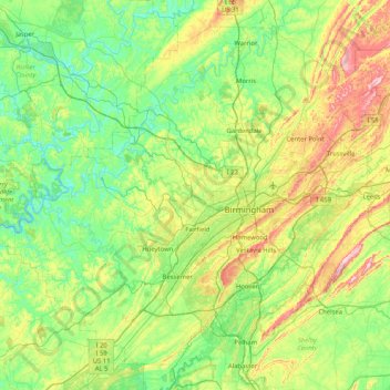
Name: Jefferson County topographic map, elevation, terrain.
Location: Jefferson County, Alabama, United States (33.24626 -87.34248 33.84341 -86.51651)
Average elevation: 568 ft
Minimum elevation: 230 ft
Maximum elevation: 1,480 ft
Alabama trails, hiking, mountain biking, running and outdoor activities
Other topographic maps
Click on a map to view its topography, its elevation and its terrain.
Gulf Shores
United States > Alabama > Gulf Shores
Jack Edwards National Airport is located in Gulf Shores and offers services from Gulf Air Center, Salt Air Aviation Center and Platium Air Center. The airport is located in town, two miles from the beach. Their FBO Gulf Air Center will provide a rental vehicle while they take care of fueling and storing…
Average elevation: 20 ft
Greater Washington Park
United States > Alabama > Montgomery County > Montgomery
Average elevation: 174 ft
Rickwood Caverns State Park
United States > Alabama > Blount County > Warrior > Reids
Average elevation: 738 ft
Cheaha Mountain
United States > Alabama > Cleburne County
Cheaha Mountain is part of the Talladega Mountains, a small section of the Ridge and Valley Mountains, unlike other elevations of the Appalachians in north Alabama, which are part of the Cumberland Plateau. The mountain is the highest point in the eastern portion of the Sun Belt (east of the Mississippi River,…
Average elevation: 1,781 ft
Crestline Heights
United States > Alabama > Jefferson County > Mountain Brook
Average elevation: 791 ft
Biltmore Estates
United States > Alabama > Jefferson County > Vestavia Hills
Average elevation: 810 ft
Coden
United States > Alabama > Mobile County
Coden is located at 30°22′59″N 88°14′18″W / 30.38306°N 88.23833°W / 30.38306; -88.23833 and has an elevation of 7 feet (2 m).
Average elevation: 10 ft
Coden
United States > Alabama > Mobile County
Coden is located at 30°22′59″N 88°14′18″W / 30.38306°N 88.23833°W / 30.38306; -88.23833 and has an elevation of 7 feet (2 m).
Average elevation: 10 ft