
Venango County topographic map
Interactive map
Click on the map to display elevation.
About this map
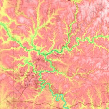
Name: Venango County topographic map, elevation, terrain.
Location: Venango County, Pennsylvania, United States (41.17166 -80.00100 41.62465 -79.47788)
Average elevation: 1,411 ft
Minimum elevation: 853 ft
Maximum elevation: 1,762 ft
Pennsylvania trails, hiking, mountain biking, running and outdoor activities
Other topographic maps
Click on a map to view its topography, its elevation and its terrain.
East Texas
United States > Pennsylvania > Lehigh County > Lower Macungie Township
Average elevation: 413 ft
11th and Pike Playground
United States > Pennsylvania > Berks County > Reading
Average elevation: 433 ft
Dingmans Ferry
United States > Pennsylvania > Pike County > Delaware Township
Average elevation: 630 ft
Observatory Hill
United States > Pennsylvania > Allegheny County > Pittsburgh
Average elevation: 1,047 ft
Nottingham County Park
United States > Pennsylvania > Chester County > West Nottingham Township
Average elevation: 449 ft
Marble Hall
United States > Pennsylvania > Montgomery County > Whitemarsh Township
Average elevation: 210 ft
Mount Zion
United States > Pennsylvania > Cumberland County > South Middleton Township
Average elevation: 587 ft
Parkers Glen
United States > Pennsylvania > Pike County > Shohola Township
Average elevation: 1,007 ft
Roaring Brook
United States > Pennsylvania > Luzerne County > Hunlock Township
Average elevation: 1,106 ft
Mustard
United States > Pennsylvania > Allegheny County > Elizabeth Township
Average elevation: 1,017 ft
Allegheny River Lock and Dam No. 2
United States > Pennsylvania > Allegheny County > O'Hara Township
Average elevation: 879 ft
Franklinville
United States > Pennsylvania > Montgomery County > Whitpain Township
Average elevation: 308 ft
Gladwyne
United States > Pennsylvania > Montgomery County > Lower Merion Township
Average elevation: 302 ft
Blue Mountain
United States > Pennsylvania > Schuylkill County > Washington Township
The ridge of Blue Mountain runs for 150 miles (240 km) through Pennsylvania, reaching an elevation of 2,270 feet (690 m) above sea level just north of the Pennsylvania Turnpike, near the borough of Newburg. Most of the ridgecrest, however, only reaches between 1,400 and 1,700 feet (430 and 520 m) in elevation.…
Average elevation: 741 ft
Longwood Gardens
United States > Pennsylvania > Chester County > East Marlborough Township
Average elevation: 410 ft
Williamsburg
United States > Pennsylvania > Armstrong County > East Franklin Township
Average elevation: 1,047 ft
Blue Ridge
United States > Pennsylvania > Bucks County > Bristol Township > Levittown
Average elevation: 52 ft
Stoneybrooke Woods
United States > Pennsylvania > Allegheny County > Cheswick
Average elevation: 928 ft
Buttonwood
United States > Pennsylvania > Lycoming County > Jackson Township
Average elevation: 1,788 ft
Highland Park Reservoir No. 2
United States > Pennsylvania > Allegheny County > Pittsburgh
Average elevation: 902 ft
Madisonville
United States > Pennsylvania > Lackawanna County > Madison Township
Average elevation: 1,680 ft
Ashmead Village
United States > Pennsylvania > Montgomery County > Cheltenham Township > Cheltenham
Average elevation: 167 ft
Stevens Point
United States > Pennsylvania > Susquehanna County > Harmony Township
Average elevation: 1,424 ft
Pendle Hill
United States > Pennsylvania > Delaware County > Nether Providence Township
Average elevation: 200 ft
Southampton
United States > Pennsylvania > Bucks County > Upper Southampton Township
Average elevation: 246 ft
Atlas
United States > Pennsylvania > Northumberland County > Mount Carmel Township
Average elevation: 1,263 ft
Alverton
United States > Pennsylvania > Westmoreland County > East Huntingdon Township
Average elevation: 1,184 ft
Chestnut Crossroads
United States > Pennsylvania > Cumberland County > Southampton Township
Average elevation: 840 ft
Saint Boniface
United States > Pennsylvania > Cambria County > Elder Township
Average elevation: 1,946 ft
Sunset
United States > Pennsylvania > Lebanon County > North Lebanon Township
Average elevation: 591 ft
Horningford
United States > Pennsylvania > Mifflin County > Bratton Township
Average elevation: 663 ft
Blue Mountain
United States > Pennsylvania > Monroe County > Eldred Township
The ridge of Blue Mountain runs for 150 miles (240 km) through Pennsylvania, reaching an elevation of 2,270 feet (690 m) above sea level just north of the Pennsylvania Turnpike, near the borough of Newburg. Most of the ridgecrest, however, only reaches between 1,400 and 1,700 feet (430 and 520 m) in elevation.…
Average elevation: 794 ft
Park Place
United States > Pennsylvania > Schuylkill County > Mahanoy Township
Average elevation: 1,690 ft
Portlamd Waterfront Park
United States > Pennsylvania > Northampton County > Portland
Average elevation: 387 ft
Atlasburg
United States > Pennsylvania > Washington County > Smith Township
Average elevation: 1,165 ft
Hamburg Reservoir
United States > Pennsylvania > Berks County > Windsor Township
Average elevation: 1,112 ft
Cedars
United States > Pennsylvania > Montgomery County > Worcester Township
Average elevation: 230 ft
Millwood
United States > Pennsylvania > Westmoreland County > Derry Township
Average elevation: 1,335 ft
Jeffersonville
United States > Pennsylvania > Montgomery County > West Norriton Township
Average elevation: 184 ft
North Springfield
United States > Pennsylvania > Erie County > Springfield Township
Average elevation: 653 ft
Brier Hill
United States > Pennsylvania > Fayette County > Redstone Township
Average elevation: 1,135 ft
Millburn
United States > Pennsylvania > Mercer County > Springfield Township
Average elevation: 1,168 ft
Fort Hunter
United States > Pennsylvania > Dauphin County > Middle Paxton Township
Average elevation: 489 ft
Faylor Lake
United States > Pennsylvania > Snyder County > Spring Township > Beaver Springs
Average elevation: 646 ft
Moorestown
United States > Pennsylvania > Northampton County > Moore Township
Average elevation: 719 ft
Buffington
United States > Pennsylvania > Fayette County > Menallen Township
Average elevation: 1,086 ft
Elders Ridge
United States > Pennsylvania > Indiana County > Young Township
Average elevation: 1,201 ft
Grassmere Park
United States > Pennsylvania > Columbia County > Sugarloaf Township
Average elevation: 1,165 ft
Elimsport
United States > Pennsylvania > Lycoming County > Washington Township
Average elevation: 630 ft
Bastress
United States > Pennsylvania > Lycoming County > Bastress Township
Average elevation: 1,237 ft
Beaver Valley
United States > Pennsylvania > Cambria County > Clearfield Township
Average elevation: 1,614 ft
Faylor Lake
United States > Pennsylvania > Snyder County > Spring Township > Beaver Springs
Average elevation: 646 ft
Montage Mountain
United States > Pennsylvania > Lackawanna County > Scranton
Average elevation: 1,585 ft
Springtown
United States > Pennsylvania > Luzerne County > Dorrance Township
Average elevation: 1,299 ft
East Waterford
United States > Pennsylvania > Juniata County > Tuscarora Township
Average elevation: 843 ft
Hickory Run State Park
United States > Pennsylvania > Carbon County > Kidder Township
Average elevation: 1,545 ft
Bonnie Brook
United States > Pennsylvania > Butler County > Summit Township
Average elevation: 1,204 ft
Cove Mountain
United States > Pennsylvania > Lycoming County > Gamble Township
Average elevation: 1,398 ft
Gladhill (Greenstone P.O.)
United States > Pennsylvania > Adams County > Hamiltonban Township
Average elevation: 1,198 ft
Booths Corner
United States > Pennsylvania > Delaware County > Bethel Township
Average elevation: 344 ft
Locust Grove
United States > Pennsylvania > Lancaster County > Conoy Township
Average elevation: 315 ft
Whitehorse
United States > Pennsylvania > Chester County > Willistown Township
Average elevation: 384 ft
Bardwell
United States > Pennsylvania > Wyoming County > Tunkhannock Township
Average elevation: 974 ft
Slate Lick
United States > Pennsylvania > Armstrong County > South Buffalo Township
Average elevation: 1,168 ft
East Nantmeal
United States > Pennsylvania > Chester County > East Nantmeal Township
Average elevation: 646 ft
Pine Grove Furnace
United States > Pennsylvania > Cumberland County > Cooke Township
Average elevation: 1,089 ft
Chadds Ford
United States > Pennsylvania > Delaware County > Chadds Ford Township
Average elevation: 282 ft
Southampton
United States > Pennsylvania > Bucks County > Upper Southampton Township
Average elevation: 246 ft
Gilbert
United States > Pennsylvania > Monroe County > Chestnuthill Township
Average elevation: 794 ft
Brandywine Village
United States > Pennsylvania > Montgomery County > Upper Merion Township
Average elevation: 164 ft
Forkston
United States > Pennsylvania > Wyoming County > Forkston Township
Average elevation: 1,161 ft