
Leechtown topographic map
Click on the map to display elevation.
About this map
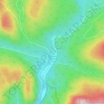
Name: Leechtown topographic map, elevation, terrain.
Average elevation: 778 ft
Minimum elevation: 410 ft
Maximum elevation: 1,424 ft
Other topographic maps
Click on a map to view its topography, its elevation and its terrain.
East Sooke
Canada > British Columbia > Capital Regional District > Juan de Fuca Electoral Area
Average elevation: 180 ft
Sooke Potholes Regional Park
Canada > British Columbia > Capital Regional District > Juan de Fuca Electoral Area
Average elevation: 978 ft
Otter Point
Canada > British Columbia > Capital Regional District > Juan de Fuca Electoral Area
Average elevation: 558 ft
San Juan River
Canada > British Columbia > Capital Regional District > Juan de Fuca Electoral Area
Average elevation: 121 ft
Port Renfrew
Canada > British Columbia > Capital Regional District > Juan de Fuca Electoral Area
Average elevation: 318 ft
Sooke Hills Wilderness Regional Park
Canada > British Columbia > Capital Regional District > Juan de Fuca Electoral Area
Average elevation: 1,027 ft
Cadboro Bay
Canada > British Columbia > Capital Regional District > Juan de Fuca Electoral Area
Average elevation: 39 ft
Boneyard Lake
Canada > British Columbia > Capital Regional District > Juan de Fuca Electoral Area
Average elevation: 925 ft
Victoria
Canada > British Columbia > Capital Regional District > Juan de Fuca Electoral Area
Average elevation: 16 ft
Japan Gulch Reservoir
Canada > British Columbia > Capital Regional District > Juan de Fuca Electoral Area
Average elevation: 899 ft
Sooke Lake
Canada > British Columbia > Capital Regional District > Juan de Fuca Electoral Area
Average elevation: 1,375 ft
Goldstream River
Canada > British Columbia > Capital Regional District > Juan de Fuca Electoral Area
Average elevation: 810 ft
Fishboat Bay Park
Canada > British Columbia > Capital Regional District > Juan de Fuca Electoral Area
Average elevation: 148 ft
Young Lake
Canada > British Columbia > Capital Regional District > Juan de Fuca Electoral Area
Average elevation: 453 ft
Malahat
Canada > British Columbia > Capital Regional District > Juan de Fuca Electoral Area
Average elevation: 1,132 ft
Botanical Beach
Canada > British Columbia > Capital Regional District > Juan de Fuca Electoral Area
Average elevation: 92 ft
Lewis Reef
Canada > British Columbia > Capital Regional District > Juan de Fuca Electoral Area
Average elevation: 3 ft
Cadboro Bay
Canada > British Columbia > Capital Regional District > Juan de Fuca Electoral Area
Average elevation: 39 ft