
Victoria topographic map
Click on the map to display elevation.
About this map
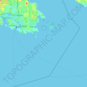
Name: Victoria topographic map, elevation, terrain.
Average elevation: 16 ft
Minimum elevation: -3 ft
Maximum elevation: 705 ft
Other topographic maps
Click on a map to view its topography, its elevation and its terrain.
Japan Gulch Reservoir
Canada > British Columbia > Capital Regional District > Juan de Fuca Electoral Area
Average elevation: 899 ft
Port Renfrew
Canada > British Columbia > Capital Regional District > Juan de Fuca Electoral Area
Average elevation: 256 ft
Leechtown
Canada > British Columbia > Capital Regional District > Juan de Fuca Electoral Area
Average elevation: 778 ft
San Juan River
Canada > British Columbia > Capital Regional District > Juan de Fuca Electoral Area
Average elevation: 121 ft
Shirley
Canada > British Columbia > Capital Regional District > Juan de Fuca Electoral Area
Average elevation: 259 ft
San Juan Ridge
Canada > British Columbia > Capital Regional District > Juan de Fuca Electoral Area
Average elevation: 2,759 ft
Goldstream River
Canada > British Columbia > Capital Regional District > Juan de Fuca Electoral Area
Average elevation: 810 ft
Young Lake
Canada > British Columbia > Capital Regional District > Juan de Fuca Electoral Area
Average elevation: 453 ft