
Make a donation
Gear up for your next adventure:
As an Amazon Associate, this site earns from qualifying purchases at no extra cost to you.
Japan Gulch Reservoir topographic map
Click on the map to display elevation.
Make a donation
Gear up for your next adventure:
As an Amazon Associate, this site earns from qualifying purchases at no extra cost to you.
About this map
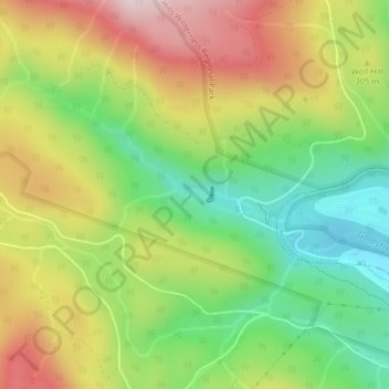
Name: Japan Gulch Reservoir topographic map, elevation, terrain.
Average elevation: 899 ft
Minimum elevation: 289 ft
Maximum elevation: 1,637 ft
Make a donation
Gear up for your next adventure:
As an Amazon Associate, this site earns from qualifying purchases at no extra cost to you.
Other topographic maps
Click on a map to view its topography, its elevation and its terrain.
Sooke Potholes Regional Park
Canada > British Columbia > Capital Regional District > Juan de Fuca Electoral Area
Average elevation: 978 ft
Port Renfrew
Canada > British Columbia > Capital Regional District > Juan de Fuca Electoral Area
Average elevation: 318 ft
Botanical Beach
Canada > British Columbia > Capital Regional District > Juan de Fuca Electoral Area
Average elevation: 92 ft
Port Renfrew
Canada > British Columbia > Capital Regional District > Juan de Fuca Electoral Area
Average elevation: 256 ft
Make a donation
Gear up for your next adventure:
As an Amazon Associate, this site earns from qualifying purchases at no extra cost to you.
Otter Point
Canada > British Columbia > Capital Regional District > Juan de Fuca Electoral Area
Average elevation: 558 ft
East Sooke
Canada > British Columbia > Capital Regional District > Juan de Fuca Electoral Area
Average elevation: 180 ft
Leechtown
Canada > British Columbia > Capital Regional District > Juan de Fuca Electoral Area
Average elevation: 778 ft
Shirley
Canada > British Columbia > Capital Regional District > Juan de Fuca Electoral Area
Average elevation: 259 ft
Make a donation
Gear up for your next adventure:
As an Amazon Associate, this site earns from qualifying purchases at no extra cost to you.
San Juan Ridge
Canada > British Columbia > Capital Regional District > Juan de Fuca Electoral Area
Average elevation: 2,759 ft
Sooke Hills Wilderness Regional Park
Canada > British Columbia > Capital Regional District > Juan de Fuca Electoral Area
Average elevation: 1,027 ft
Cadboro Bay
Canada > British Columbia > Capital Regional District > Juan de Fuca Electoral Area
Average elevation: 39 ft
Boneyard Lake
Canada > British Columbia > Capital Regional District > Juan de Fuca Electoral Area
Average elevation: 925 ft
Make a donation
Gear up for your next adventure:
As an Amazon Associate, this site earns from qualifying purchases at no extra cost to you.
Victoria
Canada > British Columbia > Capital Regional District > Juan de Fuca Electoral Area
Average elevation: 16 ft
Sooke Lake
Canada > British Columbia > Capital Regional District > Juan de Fuca Electoral Area
Average elevation: 1,375 ft
Fishboat Bay Park
Canada > British Columbia > Capital Regional District > Juan de Fuca Electoral Area
Average elevation: 148 ft
Malahat
Canada > British Columbia > Capital Regional District > Juan de Fuca Electoral Area
Average elevation: 1,132 ft
Make a donation
Gear up for your next adventure:
As an Amazon Associate, this site earns from qualifying purchases at no extra cost to you.
Lewis Reef
Canada > British Columbia > Capital Regional District > Juan de Fuca Electoral Area
Average elevation: 3 ft
Cadboro Bay
Canada > British Columbia > Capital Regional District > Juan de Fuca Electoral Area
Average elevation: 39 ft