
Ladue topographic map
Click on the map to display elevation.
About this map
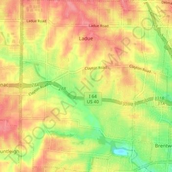
Name: Ladue topographic map, elevation, terrain.
Location: Ladue, Saint Louis County, Missouri, 63124, United States (38.60966 -90.40603 38.66122 -90.34877)
Average elevation: 554 ft
Minimum elevation: 417 ft
Maximum elevation: 653 ft
Saint Louis County trails, hiking, mountain biking, running and outdoor activities
Other topographic maps
Click on a map to view its topography, its elevation and its terrain.
Town and Country
United States > Missouri > Saint Louis County > Town and Country > Town and Country
Average elevation: 584 ft
University City
United States > Missouri > Saint Louis County > University City > University City
Average elevation: 558 ft
Clarkson Valley
United States > Missouri > Saint Louis County > Clarkson Valley
Average elevation: 640 ft
Jennings
United States > Missouri > Saint Louis County > Jennings > Jennings
Average elevation: 518 ft