
Make a donation
Gear up for your next adventure:
As an Amazon Associate, this site earns from qualifying purchases at no extra cost to you.
Quiroga topographic map
Click on the map to display elevation.
Make a donation
Gear up for your next adventure:
As an Amazon Associate, this site earns from qualifying purchases at no extra cost to you.
About this map
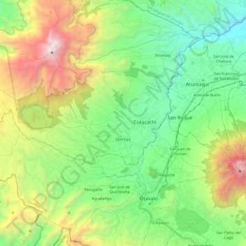
Name: Quiroga topographic map, elevation, terrain.
Location: Quiroga, Cotacachi, Imbabura, Ecuador (0.25890 -78.49549 0.33478 -78.27428)
Average elevation: 9,491 ft
Minimum elevation: 6,250 ft
Maximum elevation: 16,014 ft
Make a donation
Gear up for your next adventure:
As an Amazon Associate, this site earns from qualifying purchases at no extra cost to you.
Other topographic maps
Click on a map to view its topography, its elevation and its terrain.
Make a donation
Gear up for your next adventure:
As an Amazon Associate, this site earns from qualifying purchases at no extra cost to you.
Cotacachi
Ecuador > Imbabura > Cotacachi > Imantag
El Cotacachi (Cutacachi o Mama Cutacachi en quichua o kichwa) es un volcán que se encuentra ubicado en la provincia de Imbabura, cantón Cotacachi, en Ecuador. Alcanza una elevación de 4944 m s. n. m. Al noreste del volcán se encuentra la ciudad de Cotacachi y al sureste, la laguna de Cuicocha.
Average elevation: 14,137 ft
Make a donation
Gear up for your next adventure:
As an Amazon Associate, this site earns from qualifying purchases at no extra cost to you.
Make a donation
Gear up for your next adventure:
As an Amazon Associate, this site earns from qualifying purchases at no extra cost to you.
Make a donation
Gear up for your next adventure:
As an Amazon Associate, this site earns from qualifying purchases at no extra cost to you.
Cotacachi
Ecuador > Imbabura > Cotacachi > Imantag
El Cotacachi (Cutacachi o Mama Cutacachi en quichua o kichwa) es un volcán que se encuentra ubicado en la provincia de Imbabura, cantón Cotacachi, en Ecuador. Alcanza una elevación de 4944 m s. n. m. Al noreste del volcán se encuentra la ciudad de Cotacachi y al sureste, la laguna de Cuicocha.
Average elevation: 14,137 ft