
Lumut topographic map
Click on the map to display elevation.
About this map
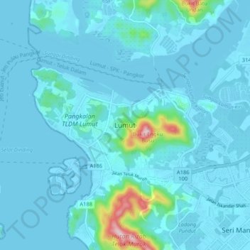
Name: Lumut topographic map, elevation, terrain.
Location: Lumut, Manjung, Perak, 32200, Malaysia (4.18465 100.58115 4.26465 100.66115)
Average elevation: 82 ft
Minimum elevation: -10 ft
Maximum elevation: 1,020 ft
Other topographic maps
Click on a map to view its topography, its elevation and its terrain.
Proposed Aboriginal Area Reserve of Chinggong (Jernang)
Malaysia > Perak > Kampung Behrang Ulu
Average elevation: 243 ft
Kampung Baru Simpang Pulai
Malaysia > Perak > Kg. Baru Simpang Pulai > Kampung Baru Simpang Pulai
Average elevation: 177 ft