
Make a donation
Gear up for your next adventure:
As an Amazon Associate, this site earns from qualifying purchases at no extra cost to you.
Sabugal topographic map
Click on the map to display elevation.
Make a donation
Gear up for your next adventure:
As an Amazon Associate, this site earns from qualifying purchases at no extra cost to you.
Sabugal
Sabugal (European Portuguese pronunciation: [sɐβuˈɣal] ) is a city and a municipality in the District of Guarda, Portugal. A border municipality with Spain, the population of the municipality in 2011 was 12,544, in an area of 822.70 km2. The city proper, located along the Côa river, has a population of about 3,000 inhabitants. There is a castle in the city of Sabugal proper as well as other castles outside the urban centre in a number of places around the entire municipality of Sabugal. Those are the castles of Sortelha, Alfaiates, Vilar Maior and Vila do Touro. The municipal holiday is the Monday after Octave of Easter. It is also place for the Sabugal Dam built in 2000 and the river beach of Devesa, both located in the Côa river. At an elevation of roughly 750 m (2460 ft) above sea level, Sabugal is among the highest cities in Portugal.
Make a donation
Gear up for your next adventure:
As an Amazon Associate, this site earns from qualifying purchases at no extra cost to you.
About this map
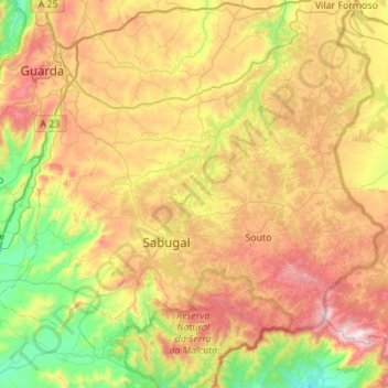
Name: Sabugal topographic map, elevation, terrain.
Location: Sabugal, Guarda, Portugal (40.25390 -7.33256 40.55299 -6.78096)
Average elevation: 2,503 ft
Minimum elevation: 1,266 ft
Maximum elevation: 4,272 ft
Make a donation
Gear up for your next adventure:
As an Amazon Associate, this site earns from qualifying purchases at no extra cost to you.
Other topographic maps
Click on a map to view its topography, its elevation and its terrain.
Make a donation
Gear up for your next adventure:
As an Amazon Associate, this site earns from qualifying purchases at no extra cost to you.
Make a donation
Gear up for your next adventure:
As an Amazon Associate, this site earns from qualifying purchases at no extra cost to you.
Make a donation
Gear up for your next adventure:
As an Amazon Associate, this site earns from qualifying purchases at no extra cost to you.
Make a donation
Gear up for your next adventure:
As an Amazon Associate, this site earns from qualifying purchases at no extra cost to you.
Porto Soito
Portugal > Guarda > Figueiró da Serra e Freixo da Serra > Figueiró da Serra > Porto Soito
Average elevation: 2,369 ft