Geolocate

Palermo topographic map

Click on the map to display elevation.

About this map

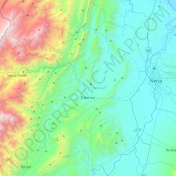
Name: Palermo topographic map, elevation, terrain.

Location: Palermo, Norte, Huila, RAP (Especial) Central, Colombia (2.72236 -75.62440 3.09778 -75.28816)

Average elevation: 3,199 ft

Minimum elevation: 1,296 ft

Maximum elevation: 9,938 ft

Other topographic maps

Click on a map to view its topography, its elevation and its terrain.

Carmen De Bolívar

Colombia > Huila > Santa María

Average elevation: 8,517 ft

GUACIRCO

Colombia > Huila > Neiva

Average elevation: 1,355 ft

San Augustin

Colombia > Huila > Colombia

Average elevation: 5,440 ft

Altamira

Colombia > Huila > Altamira

Altamira is a small pueblo in the department Huila, with a population around 2,416. Its geographical coordinates are 2° 3' 46" North, 75° 47' 14" West. It is about an 8-hour bus trip south of Bogota. The largest city in Huila and its capital is Neiva, which is 89 miles north, with a population of about…

Average elevation: 3,386 ft

Salto de Bordones

Colombia > Huila > Isnos

Average elevation: 5,669 ft

Fortalecillas

Colombia > Huila

Average elevation: 1,424 ft

Buenos Aires

Colombia > Huila > Palermo

Average elevation: 2,628 ft

El Avila

Colombia > Huila > Neiva

Average elevation: 5,387 ft

Gear up for your next adventure:

🦟Ultrasonic Repellers - Create a bug-free zone at your camp or rest stop
Camping Coffee Makers - Enjoy premium coffee at the summit or campsite
🥄Camping Utensil Set - Lightweight utensils for outdoor meals
🪵Folding Camp Saw - Compact saw for wood and campsite work
🧦Hiking Socks - Comfortable socks to prevent blisters on long hikes

As an Amazon Associate, this site earns from qualifying purchases at no extra cost to you.