
Fortalecillas topographic map
Click on the map to display elevation.
About this map
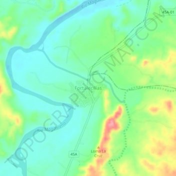
Name: Fortalecillas topographic map, elevation, terrain.
Location: Fortalecillas, Norte, Huila, Colombia (3.01755 -75.27068 3.05755 -75.23068)
Average elevation: 1,424 ft
Minimum elevation: 1,319 ft
Maximum elevation: 1,654 ft
Other topographic maps
Click on a map to view its topography, its elevation and its terrain.
Altamira
Altamira is a small pueblo in the department Huila, with a population around 2,416. Its geographical coordinates are 2° 3' 46" North, 75° 47' 14" West. It is about an 8-hour bus trip south of Bogota. The largest city in Huila and its capital is Neiva, which is 89 miles north, with a population of about…
Average elevation: 3,386 ft
La Plata
La Plata is a town and municipality in the Huila Department, Colombia, with a municipal population of 61,026 (2018 census) including the rural area, situated at an altitude of 1,050 m. It is located 122 km away from Neiva, 147 km from the city of Popayán and 210 km from the town of San Agustín.
Average elevation: 5,089 ft
Reserva Natural de la Sociedad Civil La Esperanza
Average elevation: 4,721 ft
Yaguará
Yaguará (Spanish pronunciation: [ɟʝaɣwaˈɾa]) is a town and municipality in the Huila Department, Colombia. The urban centre is located at an elevation of 650 metres (2,130 ft) in the Magdalena River Valley and the Eastern Ranges of the Colombian Andes. The municipality borders Teruel and Palermo in the…
Average elevation: 2,762 ft
Perímetro Urbano Neiva
Due to its location near the equator and its low altitude, the city has a hot annual average climate with daytime temperatures ranging from 88 to 95 degrees Fahrenheit. It is about 300 kilometers / 186.4 miles (about a five-hour drive) from the Colombian capital, Bogotá.
Average elevation: 1,539 ft