
Höfe topographic map
Interactive map
Click on the map to display elevation.
About this map
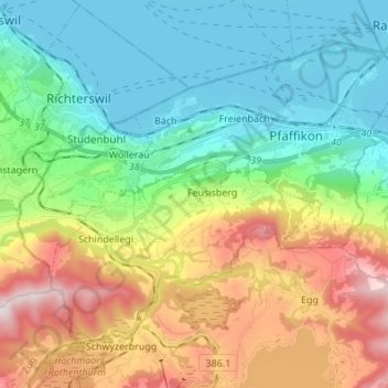
Name: Höfe topographic map, elevation, terrain.
Location: Höfe, Schwyz, Suisse (47.15027 8.68035 47.22257 8.81633)
Average elevation: 2,208 ft
Minimum elevation: 1,319 ft
Maximum elevation: 3,993 ft
Other topographic maps
Click on a map to view its topography, its elevation and its terrain.
Lac des Quatre Cantons
Lac des Quatre Cantons, Gersau, Schwyz, Suisse
Average elevation: 2,907 ft
Willerzell
Suisse > Schwyz > Einsiedeln > Einsiedeln
Willerzell, Einsiedeln, Schwyz, 8840, Suisse
Average elevation: 3,143 ft
Rickenbach
Suisse > Schwyz > Schwyz > Schwytz
Rickenbach, Schwytz, Schwyz, 6432, Suisse
Average elevation: 2,464 ft
Roetstock
Suisse > Schwyz > Vorderthal
Roetstock, Vorderthal, March, Schwyz, 8857, Suisse
Average elevation: 3,314 ft