
Make a donation
Gear up for your next adventure:
As an Amazon Associate, this site earns from qualifying purchases at no extra cost to you.
Aeolian Islands topographic map
Click on the map to display elevation.
Make a donation
Gear up for your next adventure:
As an Amazon Associate, this site earns from qualifying purchases at no extra cost to you.
Aeolian Islands
The largest island is Lipari (37.5 km²), followed by Salina (26.8 km²), Vulcano (21.2 km²), Stromboli (12.6 km²), Filicudi (9.5 km²) and Alicudi (5.2 km²). The smallest island with 3.4 km² is Panarea. The highest elevation of the Lipari Islands is Monte Fossa delle Felci on Salina, which reaches a height of 962 m.
Make a donation
Gear up for your next adventure:
As an Amazon Associate, this site earns from qualifying purchases at no extra cost to you.
About this map
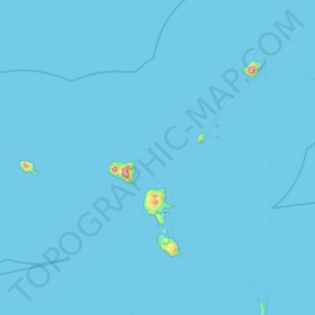
Name: Aeolian Islands topographic map, elevation, terrain.
Location: Aeolian Islands, Messina, Sicily, Italy (38.36668 14.33904 38.81766 15.25268)
Average elevation: 13 ft
Minimum elevation: 0 ft
Maximum elevation: 2,999 ft
Make a donation
Gear up for your next adventure:
As an Amazon Associate, this site earns from qualifying purchases at no extra cost to you.
Other topographic maps
Click on a map to view its topography, its elevation and its terrain.
Make a donation
Gear up for your next adventure:
As an Amazon Associate, this site earns from qualifying purchases at no extra cost to you.
Make a donation
Gear up for your next adventure:
As an Amazon Associate, this site earns from qualifying purchases at no extra cost to you.
Make a donation
Gear up for your next adventure:
As an Amazon Associate, this site earns from qualifying purchases at no extra cost to you.
Make a donation
Gear up for your next adventure:
As an Amazon Associate, this site earns from qualifying purchases at no extra cost to you.
Make a donation
Gear up for your next adventure:
As an Amazon Associate, this site earns from qualifying purchases at no extra cost to you.
Make a donation
Gear up for your next adventure:
As an Amazon Associate, this site earns from qualifying purchases at no extra cost to you.