
Marion County topographic map
Interactive map
Click on the map to display elevation.
About this map
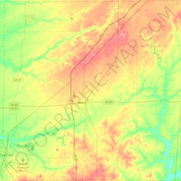
Name: Marion County topographic map, elevation, terrain.
Location: Marion County, Illinois, USA (38.47414 -89.14445 38.82556 -88.69620)
Average elevation: 535 ft
Minimum elevation: 420 ft
Maximum elevation: 656 ft
Other topographic maps
Click on a map to view its topography, its elevation and its terrain.
Northbrook
USA > Illinois > Northbrook
Northbrook, Cook County, Illinois, 60062, USA
Average elevation: 659 ft
Douglas Park
USA > Illinois > Douglas Park
Douglas Park, Whiteside County, Illinois, 61037, USA
Average elevation: 646 ft
Garfield Ridge
Garfield Ridge, Chicago, Cook County, Illinois, USA
Average elevation: 604 ft
Montague Island
Montague Island, Rockford, Winnebago County, Illinois, 61104, USA
Average elevation: 833 ft