Geolocate

Pelion topographic map

Click on the map to display elevation.

About this map
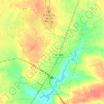
Name: Pelion topographic map, elevation, terrain.

Location: Pelion, Lexington County, South Carolina, 29123, United States (33.74870 -81.27324 33.80762 -81.22892)

Average elevation: 420 ft

Minimum elevation: 322 ft

Maximum elevation: 499 ft

Lexington County trails, hiking, mountain biking, running and outdoor activities

Other topographic maps

Click on a map to view its topography, its elevation and its terrain.

Hillside

United States > South Carolina > Lexington County

Average elevation: 354 ft

Chapin

United States > South Carolina > Lexington County > Chapin

Average elevation: 423 ft

Cayce

United States > South Carolina > Lexington County > Cayce

Average elevation: 272 ft

Walden

United States > South Carolina > Lexington County

Average elevation: 259 ft

Gear up for your next adventure:

🪑Ultralight Camp Chairs - Portable seating for resting after a long day of mapping
🏕️Tent Footprint - Protect your tent base from wear
🗻Climbing Gear Basics - Essential gear for beginner climbers
🛡️Insect Repellent - Protection against bugs during outdoor activities
🌡️Portable Weather Meter - Track weather conditions on the trail

As an Amazon Associate, this site earns from qualifying purchases at no extra cost to you.