
Pelion topographic map
Click on the map to display elevation.
About this map
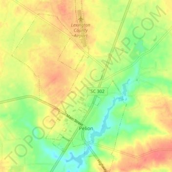
Name: Pelion topographic map, elevation, terrain.
Average elevation: 420 ft
Minimum elevation: 322 ft
Maximum elevation: 499 ft
Lexington County trails, hiking, mountain biking, running and outdoor activities
Other topographic maps
Click on a map to view its topography, its elevation and its terrain.
Peachtree Rock Heritage Preserve
United States > South Carolina > Lexington County
Average elevation: 486 ft
Edenwood
United States > South Carolina > Lexington County > Cayce > Edenwood
Average elevation: 167 ft