Geolocate

Robe topographic map

Click on the map to display elevation.

About this map

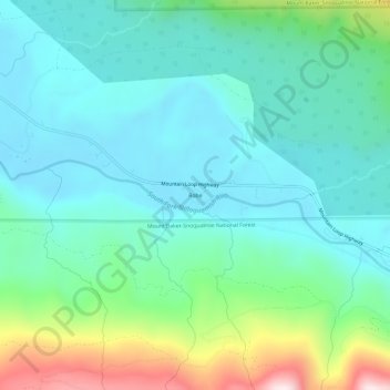
Name: Robe topographic map, elevation, terrain.

Location: Robe, Snohomish County, Washington, United States (48.07625 -121.82632 48.11625 -121.78632)

Average elevation: 1,335 ft

Minimum elevation: 869 ft

Maximum elevation: 2,881 ft

Snohomish County trails, hiking, mountain biking, running and outdoor activities

Other topographic maps

Click on a map to view its topography, its elevation and its terrain.

Esperance

United States > Washington > Snohomish County > Esperance

Average elevation: 387 ft

Lochsloy

United States > Washington > Snohomish County

Average elevation: 367 ft

Lake Stickney

United States > Washington > Snohomish County

Average elevation: 3,625 ft

Brier

United States > Washington > Snohomish County

Average elevation: 344 ft

Bowser Lake

United States > Washington > Snohomish County

Average elevation: 4,570 ft

Martha Lake

United States > Washington > Snohomish County

Average elevation: 433 ft

North Creek

United States > Washington > Snohomish County

Average elevation: 325 ft

Verlot

United States > Washington > Snohomish County

Average elevation: 2,336 ft

Dagger Lake

United States > Washington > Snohomish County

Average elevation: 965 ft

Gear up for your next adventure:

🧯Portable Fire Pit - Compact fire pit for camping spots
🧣Hiking Neck Gaiter - Multi‑use neck protection for outdoor weather
👖Convertible Hiking Pants - Versatile zip-off pants for changing altitudes and temperatures
😴Insulated Sleeping Pads - Compact and warm pads for high-elevation camping
🔪Outdoor Multitools - Essential survival tools for gear repair and field use

As an Amazon Associate, this site earns from qualifying purchases at no extra cost to you.