
Picnic Point-North Lynnwood topographic map
Interactive map
Click on the map to display elevation.
About this map
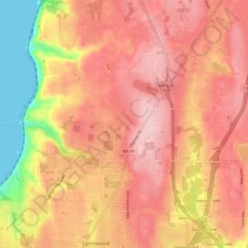
Name: Picnic Point-North Lynnwood topographic map, elevation, terrain.
Average elevation: 417 ft
Minimum elevation: -3 ft
Maximum elevation: 643 ft
Snohomish County trails, hiking, mountain biking, running and outdoor activities
Other topographic maps
Click on a map to view its topography, its elevation and its terrain.
Northwest Snohomish
United States > Washington > Snohomish County > Snohomish
Average elevation: 174 ft
Mill Creek
United States > Washington > Snohomish County > Mill Creek > Mill Creek
Average elevation: 423 ft
Snohomish
United States > Washington > Snohomish County > Snohomish > Snohomish
Average elevation: 118 ft
Totem Park
United States > Washington > Snohomish County > Arlington > Totem Park
Average elevation: 112 ft
Granite Falls
United States > Washington > Snohomish County > Granite Falls > Granite Falls
Average elevation: 469 ft
Lynnwood
United States > Washington > Snohomish County > Lynnwood > Lynnwood
Average elevation: 367 ft