
Make a donation
Gear up for your next adventure:
As an Amazon Associate, this site earns from qualifying purchases at no extra cost to you.
Lake Stickney topographic map
Click on the map to display elevation.
Make a donation
Gear up for your next adventure:
As an Amazon Associate, this site earns from qualifying purchases at no extra cost to you.
About this map
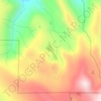
Name: Lake Stickney topographic map, elevation, terrain.
Location: Lake Stickney, Snohomish County, Washington, United States (47.91638 -121.63652 47.92145 -121.63170)
Average elevation: 3,625 ft
Minimum elevation: 2,316 ft
Maximum elevation: 4,783 ft
Snohomish County trails, hiking, mountain biking, running and outdoor activities
Make a donation
Gear up for your next adventure:
As an Amazon Associate, this site earns from qualifying purchases at no extra cost to you.
Other topographic maps
Click on a map to view its topography, its elevation and its terrain.
Make a donation
Gear up for your next adventure:
As an Amazon Associate, this site earns from qualifying purchases at no extra cost to you.
Make a donation
Gear up for your next adventure:
As an Amazon Associate, this site earns from qualifying purchases at no extra cost to you.
Make a donation
Gear up for your next adventure:
As an Amazon Associate, this site earns from qualifying purchases at no extra cost to you.
Granite Falls
United States > Washington > Snohomish County > Granite Falls > Granite Falls
Average elevation: 469 ft
Make a donation
Gear up for your next adventure:
As an Amazon Associate, this site earns from qualifying purchases at no extra cost to you.
Totem Park
United States > Washington > Snohomish County > Arlington > Totem Park
Average elevation: 112 ft
Mill Creek
United States > Washington > Snohomish County > Mill Creek > Mill Creek
Average elevation: 423 ft
Lynnwood
United States > Washington > Snohomish County > Lynnwood > Lynnwood
Average elevation: 367 ft
Snohomish
United States > Washington > Snohomish County > Snohomish > Snohomish
Average elevation: 118 ft
Make a donation
Gear up for your next adventure:
As an Amazon Associate, this site earns from qualifying purchases at no extra cost to you.