Geolocate

Dagger Lake topographic map

Click on the map to display elevation.

About this map

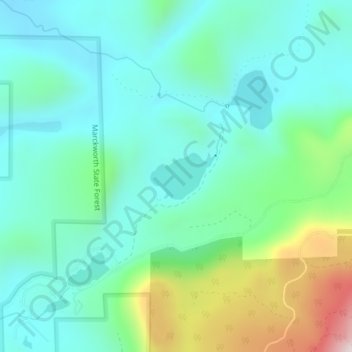
Name: Dagger Lake topographic map, elevation, terrain.

Location: Dagger Lake, Snohomish County, Washington, United States (47.81156 -121.79840 47.81513 -121.79086)

Average elevation: 965 ft

Minimum elevation: 499 ft

Maximum elevation: 2,438 ft

Snohomish County trails, hiking, mountain biking, running and outdoor activities

Other topographic maps

Click on a map to view its topography, its elevation and its terrain.

Pilchuck

United States > Washington > Snohomish County

Average elevation: 653 ft

Bryant

United States > Washington > Snohomish County

Average elevation: 207 ft

Oso

United States > Washington > Snohomish County

Average elevation: 387 ft

Esperance

United States > Washington > Snohomish County > Esperance

Average elevation: 387 ft

Lochsloy

United States > Washington > Snohomish County

Average elevation: 367 ft

Clearview

United States > Washington > Snohomish County

Average elevation: 486 ft

Lake Stickney

United States > Washington > Snohomish County

Average elevation: 3,625 ft

Brier

United States > Washington > Snohomish County

Average elevation: 344 ft

Edmonds

United States > Washington > Snohomish County > Edmonds > Edmonds

Average elevation: 164 ft

Robe

United States > Washington > Snohomish County

Average elevation: 1,335 ft

Martha Lake

United States > Washington > Snohomish County

Average elevation: 433 ft

Fortson

United States > Washington > Snohomish County

Average elevation: 899 ft

North Creek

United States > Washington > Snohomish County

Average elevation: 325 ft

Mount Pilchuck

United States > Washington > Snohomish County

Average elevation: 3,711 ft

Verlot

United States > Washington > Snohomish County

Average elevation: 2,336 ft

Everett

United States > Washington > Snohomish County > Everett

Average elevation: 220 ft

Monte Cristo

United States > Washington > Snohomish County

Average elevation: 3,868 ft

Lynnwood

United States > Washington > Snohomish County > Lynnwood > Lynnwood

Average elevation: 367 ft

Lakewood

United States > Washington > Snohomish County > Marysville

Average elevation: 144 ft

Gear up for your next adventure:

❄️Traction Cleats - Prevent slips on icy trails during winter hikes
📶Satellite Messenger - Communication device off‑grid
📶Vehicle Signal Boosters - Improve reception in rural areas while driving to trailheads
🚑Emergency Bivvies - Heat-reflective sleeping bags for survival situations
🔭Telescopic Hiking Pole - Adjustable pole for hiking stability

As an Amazon Associate, this site earns from qualifying purchases at no extra cost to you.