
Morong topographic map
Click on the map to display elevation.
Morong
The most probable etymology comes from the Spanish word morón which refers to a hill which can be seen from the sea. Several towns in Spain and in Spanish colonies are also named Morón, namely Morón in Cuba; Morón de la Fronterra in Sevilla, Spain; and Morón in Buenos Aires, Argentina, to name a few. These place all have hilly topographies and are nearby the ocean.
About this map
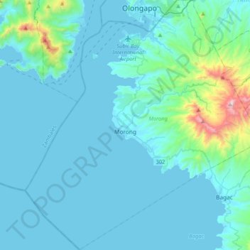
Name: Morong topographic map, elevation, terrain.
Location: Morong, Bataan, Central Luzon, 2108, Philippines (14.53137 120.13677 14.84108 120.44084)
Average elevation: 364 ft
Minimum elevation: -7 ft
Maximum elevation: 4,039 ft
Other topographic maps
Click on a map to view its topography, its elevation and its terrain.
Mariveles
Philippines > Bataan > Mariveles
Mariveles features a diverse and dynamic topography characterized by its mountainous terrain and coastal landscapes. The region is dominated by the prominent Mount Mariveles, a stratovolcano that reaches an elevation of approximately 4,531 feet (1,388 meters) at its highest point. The mountain is part of a…
Average elevation: 272 ft
Abucay
Philippines > Bataan > Abucay
Topography of Abucay varies from the mountainous terrain of Mount Natib caldera in the west to the coastal areas of the province along the shore of Manila Bay. Six rivers with a combined length of 37 kilometres (23 mi) originate from the mountain flowing in the west-to-east direction.
Average elevation: 72 ft
Mount Mariveles
Philippines > Bataan > Mariveles
Mount Mariveles is a massive stratovolcano topped with a 4-kilometre (2.5 mi) summit caldera which drains to the north. The highest peak, called Mariveles, has an elevation of 1,388 metres (4,554 ft) asl. Mounts Pantingan, Bataan, Tarak, and Vintana are the other peaks of the volcano-caldera complex, which has…
Average elevation: 2,884 ft