Geolocate

Page topographic map

Click on the map to display elevation.

About this map

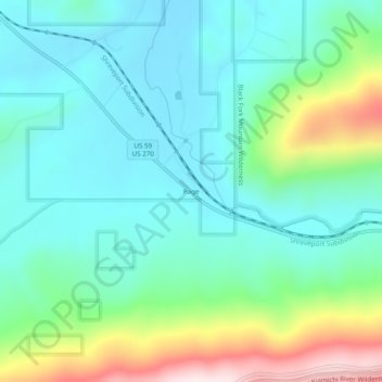
Name: Page topographic map, elevation, terrain.

Location: Page, Le Flore County, Oklahoma, United States (34.69066 -94.56967 34.73066 -94.52967)

Average elevation: 1,273 ft

Minimum elevation: 853 ft

Maximum elevation: 2,510 ft

Le Flore County trails, hiking, mountain biking, running and outdoor activities

Other topographic maps

Click on a map to view its topography, its elevation and its terrain.

Shady Point

United States > Oklahoma > Le Flore County

Average elevation: 459 ft

Fanshawe

United States > Oklahoma > Le Flore County

Average elevation: 689 ft

Pocola

United States > Oklahoma > Le Flore County

Average elevation: 482 ft

Le Flore

United States > Oklahoma > Le Flore County > Le Flore

Average elevation: 571 ft

Cameron

United States > Oklahoma > Le Flore County

Average elevation: 509 ft

Gear up for your next adventure:

🏔️Mountain Trail Maps - High‑detail maps for popular peaks
🥾Women's Hiking Boots - Top-rated trail boots with ankle support and superior grip
🔦Compact Flashlight - Reliable flashlight for emergencies
📚Navigation Handbooks - Master the art of reading topographic maps and using a compass
🎒Day Hiking Backpack - Lightweight backpack perfect for day trips and outdoor adventures

As an Amazon Associate, this site earns from qualifying purchases at no extra cost to you.