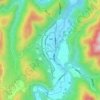
Miyoshi topographic map
Click on the map to display elevation.
Miyoshi
Miyoshi is located almost in the middle of the Chugoku region, with the Chugoku Mountains to the north and a flat agricultural area to the south. Together with the neighboring city of Shōbara, it forms the northern part of the prefecture called the "Bihoku region". Because the tributaries of the Enokawa River meet at the Miyoshi Basin, it prospered as a river port and has long functioned as a strategic point for culture, economy, and transportation connecting the San'in and San'yō regions. About one-third of the rain that falls in Hiroshima Prefecture is collected here, and it has abundant water. Due to the confluence of rivers, fog tends to occur in this area from late autumn to early spring. The center of urban area is the Miyoshi Basin, which is located between the Chugoku Mountains and the Kibi Plateau at an elevation of 150 to 250 meters. Miyoshi developed as a twin settlement, with "Itsukaichi", as the castle town of the Miyoshi clan towards the west, and the current city center district where Miyoshi Station is located as a market town called 'Tokaichi-machi' to the east.
About this map
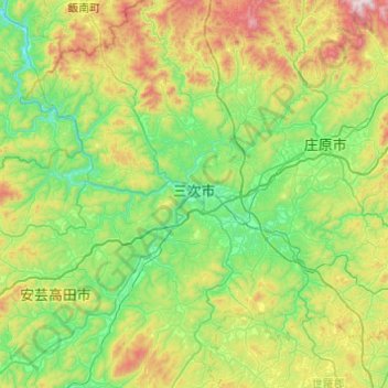
Name: Miyoshi topographic map, elevation, terrain.
Location: Miyoshi, Hiroshima Prefecture, Japan (34.60522 132.63336 35.00460 133.10966)
Average elevation: 1,266 ft
Minimum elevation: 220 ft
Maximum elevation: 3,871 ft
Other topographic maps
Click on a map to view its topography, its elevation and its terrain.

Mount Fuji
Japan > Sunto County > Oyama
Mount Fuji (富士山, Fujisan, Japanese: [ɸɯꜜ(d)ʑisaɴ] (listen)), or Fugaku, located on the island of Honshū, is the highest mountain in Japan, with a summit elevation of 3,776.24 m (12,389 ft 3 in). It is the second-highest volcano located on an island in Asia (after Mount Kerinci on the island of…
Average elevation: 10,709 ft


Mount Fuji
Japan > Sunto County > Oyama
Mount Fuji (富士山, Fujisan, Japanese: [ɸɯꜜ(d)ʑisaɴ] (listen)), or Fugaku, located on the island of Honshū, is the highest mountain in Japan, with a summit elevation of 3,776.24 m (12,389 ft 3 in). It is the second-highest volcano located on an island in Asia (after Mount Kerinci on the island of…
Average elevation: 10,709 ft


Mount Hotaka
Japan > Tone County > Kawaba
Mount Hotaka (武尊山 Hotakayama, 上州武尊山 Joshu Hotakayama) is a stratovolcano with its highest peak at the altitude of 2,158m. It is located near Minakami-machi, Kawaba Village, and Katashina Village in the Gunma Prefecture. In order to distinguish it from Mount Hotakadake in the Northern Alps, it…
Average elevation: 5,889 ft


Mount Miyanoura
Japan > Kumage County > Yakushima
Mount Miyanoura (宮之浦岳, Miyanoura-dake) is a mountain in central Yakushima in Kagoshima Prefecture. At an altitude of 1,936 m (6,352 ft), it is the highest peak of Yakushima and also the highest peak of the Kyushu region. It is one of the 100 Famous Japanese Mountains.
Average elevation: 5,341 ft


Mount Fuji
Japan > Sunto County > Oyama
Mount Fuji (富士山, Fujisan, Japanese: [ɸɯꜜ(d)ʑisaɴ] (listen)), located on the island of Honshū, is an active stratovolcano in Japan, with a summit elevation of 3,776.24 m (12,389 ft 3 in). It is the tallest mountain in Japan, the second-highest volcano located on an island in Asia (after Mount…
Average elevation: 10,699 ft


Mount Yari
Two triangulation points were established at the summit. A milepost stone is fixed to the ground. As a reference point for the Geographical Survey Institute of Japan, it is of little importance and even on topographic maps, the summit of Yari-ga-take appears merely as an elevation point.
Average elevation: 8,550 ft



Mount Fuji
Japan > Sunto County > Oyama
Mount Fuji (富士山, Fujisan, Japanese: [ɸɯꜜ(d)ʑisaɴ] ) is an active stratovolcano located on the Japanese island of Honshu, with a summit elevation of 3,776.24 m (12,389 ft 3 in). It is the highest mountain in Japan, the second-highest volcano located on an island in Asia (after Mount Kerinci on the…
Average elevation: 10,709 ft

Mount Fuji
Japan > Sunto County > Oyama
Mount Fuji (富士山, Fujisan, Japanese: [ɸɯꜜ(d)ʑisaɴ] (listen)), located on the island of Honshū, is the highest mountain in Japan, with a summit elevation of 3,776.24 m (12,389 ft 3 in). It is the second-highest volcano located on an island in Asia (after Mount Kerinci on the island of Sumatra), and…
Average elevation: 10,709 ft


Mount Aso
Japan > Aso County > Minamiaso
With an elevation of 1,143 metres (3,750 ft)., Mount Aso has a climate that falls as humid continental (Köppen climate classification "Dfb"), with warm summers and cold winters. Precipitation is high throughout the year, which brings the area to have borderline subtropical characteristics as well. It is…
Average elevation: 4,114 ft


Mount Naka
Mount Naka (中岳, Naka-dake) is a mountain with an altitude of 3,084m located in the southern part of the Hida Mountains, which straddles Matsumoto in Nagano Prefecture and Takayama in Gifu Prefecture. This mountain is located in Chūbu-Sangaku National Park.
Average elevation: 8,619 ft


Mount Fuji
Japan > Sunto County > Oyama
Mount Fuji (富士山・富士の山, Fujisan, Fuji no Yama) is an active stratovolcano located on the Japanese island of Honshu, with a summit elevation of 3,776.24 m (12,389 ft 3 in). It is the highest mountain in Japan, the second-highest volcano on any Asian island (after Mount Kerinci on the Indonesian…
Average elevation: 10,709 ft

Mount Fuji
Japan > Sunto County > Oyama
Mount Fuji (富士山・富士の山, Fujisan, Fuji no Yama) is an active stratovolcano located on the Japanese island of Honshu, with a summit elevation of 3,776.24 m (12,389 ft 3 in). It is the highest mountain in Japan, the second-highest volcano on any Asian island (after Mount Kerinci on the Indonesian…
Average elevation: 10,709 ft



Mount Fuji
Japan > Sunto County > Oyama
Mount Fuji (富士山・富士の山, Fujisan, Fuji no Yama) is an active stratovolcano located on the Japanese island of Honshu, with a summit elevation of 3,776.24 m (12,389 ft 3 in). It is the highest mountain in Japan, the second-highest volcano on any Asian island (after Mount Kerinci on the Indonesian…
Average elevation: 10,709 ft
Mt. Tate
Japan > Nakaniikawa County > Tateyama
The mountain is primarily composed of granite and gneiss. However, located along the ridge and plateau, about 2 km (1.2 mi) west of the summit, there is a small andesite-dacite stratovolcano. This volcano has an elevation of 2,621 m (8,599 ft) and has minor eruptions, the latest occurring in 1961.
Average elevation: 8,386 ft

Mount Tateshina
It has an elevation of 2,530 m (8,301 ft). This mountain is one of the 100 Famous Japanese Mountains.
Average elevation: 6,831 ft
Mount Aso
Japan > Aso County > Minamiaso
With an elevation of 1,143 metres (3,750 ft)., Mount Aso has a climate that falls as humid continental (Köppen climate classification "Dfb"), with warm summers and cold winters. Precipitation is high throughout the year, which brings the area to have borderline subtropical characteristics as well. It is…
Average elevation: 4,114 ft

Mount Chōkai
Japan > Akumi County > Yuza
Mount Chōkai is shared by two municipalities in Akita Prefecture and four municipalities Yamagata Prefecture; however, its peak is located in Yuza, on the Yamagata side of the border. It is therefore the highest peak in Yamagata, and the second highest in the Tōhoku region after Mt. Hiuchigatake (altitude…
Average elevation: 5,932 ft
Mount Fuji
Japan > Sunto County > Oyama
Mount Fuji (富士山, Fujisan, Japanese: [ɸɯꜜ(d)ʑisaɴ] ) is an active stratovolcano located on the Japanese island of Honshu, with a summit elevation of 3,776.24 m (12,389 ft 3 in). It is the tallest mountain in Japan, the second-highest volcano located on an island in Asia (after Mount Kerinci on the…
Average elevation: 10,699 ft

Shirakawa
Shirakawa is a mountain village located in far northern Gifu Prefecture, bordering Ishikawa Prefecture and Toyama Prefecture on the Ryōhaku Mountains. Mount Hakusan is the highest elevation at 2,172 metres (7,126 ft). The village's area is 95.7% mountainous forests, and its steep places are characteristic. In…
Average elevation: 2,188 ft