Geolocate

Spencerville topographic map

Click on the map to display elevation.

About this map

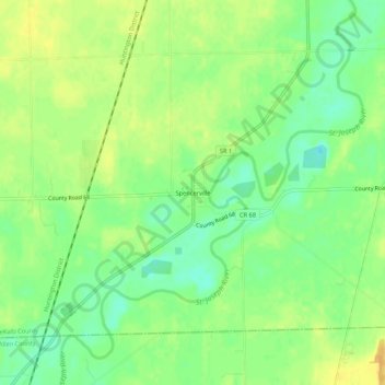
Name: Spencerville topographic map, elevation, terrain.

Location: Spencerville, DeKalb County, Indiana, 46788, United States (41.26311 -84.94191 41.30311 -84.90191)

Average elevation: 817 ft

Minimum elevation: 768 ft

Maximum elevation: 860 ft

DeKalb County trails, hiking, mountain biking, running and outdoor activities

Other topographic maps

Click on a map to view its topography, its elevation and its terrain.

Butler

United States > Indiana > DeKalb County

Average elevation: 869 ft

Corunna

United States > Indiana > DeKalb County

Average elevation: 968 ft

Altona

United States > Indiana > DeKalb County

Average elevation: 889 ft

Waterloo

United States > Indiana > DeKalb County

Average elevation: 906 ft

Auburn

United States > Indiana > DeKalb County

Average elevation: 883 ft

Gear up for your next adventure:

🎒Hydration Pack - Hands‑free water reservoir for long hikes
❄️Traction Cleats - Prevent slips on icy trails during winter hikes
🦟Ultrasonic Repellers - Create a bug-free zone at your camp or rest stop
🎒Waterproof Dry Bags - Keep your electronics and maps dry inside your pack
🛡️Bear Spray Outdoor - Protection in bear country hikes

As an Amazon Associate, this site earns from qualifying purchases at no extra cost to you.