
Wales topographic map
Interactive map
Click on the map to display elevation.
About this map
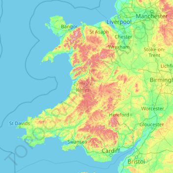
Name: Wales topographic map, elevation, terrain.
Location: Wales, United Kingdom (51.22903 -5.80773 53.63500 -2.64986)
Average elevation: 325 ft
Minimum elevation: 0 ft
Maximum elevation: 3,284 ft
Much of Wales' diverse landscape is mountainous, particularly in the north and central regions. The mountains were shaped during the last ice age, the Devensian glaciation. The highest mountains in Wales are in Snowdonia (Eryri), of which five are over 1,000 m (3,300 ft). The highest of these is Snowdon (Yr Wyddfa), at 1,085 m (3,560 ft). The 14 Welsh mountains, or 15 if including Carnedd Gwenllian – often discounted because of its low topographic prominence – over 3,000 feet (910 metres) high are known collectively as the Welsh 3000s and are located in a small area in the north-west. The highest outside the 3000s is Aran Fawddwy, at 905 metres (2,969 feet), in the south of Snowdonia. The Brecon Beacons (Bannau Brycheiniog) are in the south (highest point Pen y Fan, at 886 metres (2,907 feet)), and are joined by the Cambrian Mountains in Mid Wales (highest point Pumlumon, at 752 metres (2,467 feet)).
Other topographic maps
Click on a map to view its topography, its elevation and its terrain.
Stonehenge
United Kingdom > England > Larkhill
Stonehenge, The Avenue, Amesbury, Larkhill, Wiltshire, South West England, England, SP3 4DX, United Kingdom
Average elevation: 325 ft
Water
United Kingdom > England > Devon > Teignbridge
Water, Teignbridge, Devon, England, TQ13 9UE, United Kingdom
Average elevation: 856 ft
City of London
United Kingdom > England > City of London > City of London
City of London, England, EC2V 5AE, United Kingdom
Average elevation: 138 ft
Warmley
United Kingdom > England > South Gloucestershire
Warmley, Siston, South Gloucestershire, West of England, England, BS15 4PP, United Kingdom
Average elevation: 226 ft
Walney Channel
United Kingdom > England > Westmorland and Furness > Roa Island
Walney Channel, Roa Island, Westmorland and Furness, England, United Kingdom
Average elevation: 13 ft
Rotherham
Rotherham, South Yorkshire Mayoral Combined Authority, England, United Kingdom
Average elevation: 331 ft
Shrewsbury
United Kingdom > England > Shrewsbury
Shrewsbury, Shropshire, West Midlands, England, SY1 1SF, United Kingdom
Average elevation: 233 ft
Campbeltown
United Kingdom > Scotland > Argyll and Bute
Campbeltown, Argyll and Bute, Scotland, PA28 6AD, United Kingdom
Average elevation: 276 ft
Batley
United Kingdom > England > Kirklees
Batley, Kirklees, West Yorkshire, England, WF17 8PA, United Kingdom
Average elevation: 364 ft
London
London, Greater London, England, United Kingdom
Average elevation: 217 ft
Blackwater
United Kingdom > England > Cornwall
Blackwater, Cornwall, England, TR4 8EH, United Kingdom
Average elevation: 374 ft
Scottish Highlands
United Kingdom > Scotland > Highland
Scottish Highlands, Highland, Scotland, United Kingdom
Average elevation: 2,976 ft
Great Baddow
United Kingdom > England > Essex > Chelmsford
Great Baddow, Chelmsford, Essex, England, United Kingdom
Average elevation: 121 ft
Northampton
United Kingdom > England > West Northamptonshire > Northampton
Northampton, West Northamptonshire, England, United Kingdom
Average elevation: 292 ft
Whitnash
United Kingdom > England > Warwickshire > Warwick
Whitnash, Warwick, Warwickshire, England, United Kingdom
Average elevation: 226 ft
Rhyl
United Kingdom > Wales > Denbighshire
Rhyl, Denbighshire, Wales, LL18 1RG, United Kingdom
Average elevation: 16 ft
One Tree Close
United Kingdom > England > London
One Tree Close, Nunhead, London Borough of Southwark, London, Greater London, England, SE23 3QZ, United Kingdom
Average elevation: 141 ft
Sunderland
Sunderland, North East, England, United Kingdom
Average elevation: 151 ft
County Tyrone
United Kingdom > Northern Ireland
County Tyrone, Northern Ireland, United Kingdom
Average elevation: 394 ft
North West Leicestershire
United Kingdom > England > Leicestershire
North West Leicestershire, Leicestershire, England, United Kingdom
Average elevation: 331 ft
Hadleigh
United Kingdom > England > Essex > Castle Point
Hadleigh, Castle Point, Essex, England, SS7 2RD, United Kingdom
Average elevation: 95 ft
Royal Leamington Spa
United Kingdom > England > Royal Leamington Spa
Royal Leamington Spa, Warwickshire, West Midlands, England, CV32 4DB, United Kingdom
Average elevation: 223 ft
Great Staughton
United Kingdom > England > Cambridgeshire > Huntingdonshire
Great Staughton, Huntingdonshire, Cambridgeshire, Cambridgeshire and Peterborough, England, United Kingdom
Average elevation: 141 ft
Tigharry
United Kingdom > Scotland > Western Isles
Tigharry, Western Isles, Scotland, HS6 5DE, United Kingdom
Average elevation: 36 ft
County Durham
County Durham, North East, England, United Kingdom
Average elevation: 640 ft
Aber-Arad
United Kingdom > Wales > Carmarthenshire
Aber-Arad, Carmarthenshire, Wales, SA38 9DW, United Kingdom
Average elevation: 351 ft
Adstone
United Kingdom > England > West Northamptonshire
Adstone, West Northamptonshire, England, United Kingdom
Average elevation: 495 ft
Nether Heyford
United Kingdom > England > West Northamptonshire
Nether Heyford, West Northamptonshire, England, United Kingdom
Average elevation: 299 ft
Hadleigh
United Kingdom > England > Suffolk > Babergh
Hadleigh, Babergh, Suffolk, England, United Kingdom
Average elevation: 167 ft
Coventry
Coventry, West Midlands Combined Authority, England, United Kingdom
Average elevation: 325 ft
Rayleigh
United Kingdom > England > Essex
Rayleigh, Rochford, Essex, England, United Kingdom
Average elevation: 121 ft
Broxtowe
United Kingdom > England > Nottinghamshire
Broxtowe, Nottinghamshire, England, United Kingdom
Average elevation: 249 ft
Cardigan
United Kingdom > Wales > Ceredigion
Cardigan, Ceredigion, Wales, SA43 1JR, United Kingdom
Average elevation: 266 ft
Whitby
United Kingdom > England > Whitby
Whitby, North Yorkshire, Yorkshire and the Humber, England, YO21 3QF, United Kingdom
Average elevation: 128 ft
Coseley
Coseley, Dudley, West Midlands Combined Authority, England, WV14 9NJ, United Kingdom
Average elevation: 509 ft
Landican
United Kingdom > England > Thingwall
Landican, Thingwall, Wirral, Liverpool City Region, England, CH49 5LJ, United Kingdom
Average elevation: 148 ft
Elsdon
United Kingdom > England > Northumberland
Elsdon, Northumberland, North of Tyne, England, United Kingdom
Average elevation: 807 ft
Hanham
United Kingdom > England > South Gloucestershire
Hanham, South Gloucestershire, West of England, England, United Kingdom
Average elevation: 233 ft
Tetbury
United Kingdom > England > Gloucestershire > Cotswold District
Tetbury, Cotswold District, Gloucestershire, England, United Kingdom
Average elevation: 400 ft
Old Brampton
United Kingdom > England > Derbyshire > North East Derbyshire
Old Brampton, North East Derbyshire, Derbyshire, England, S42 7JG, United Kingdom
Average elevation: 594 ft
Broadstairs
United Kingdom > England > Kent > Thanet
Broadstairs, Thanet, Kent, England, CT10 1LH, United Kingdom
Average elevation: 46 ft
Woolavington
United Kingdom > England > Somerset
Woolavington, Somerset, England, United Kingdom
Average elevation: 56 ft
Cruwys Morchard
United Kingdom > England > Devon > Mid Devon
Cruwys Morchard, Mid Devon, Devon, England, United Kingdom
Average elevation: 636 ft
Llanboidy
United Kingdom > Wales > Carmarthenshire
Llanboidy, Carmarthenshire, Wales, SA34 0EL, United Kingdom
Average elevation: 449 ft
Codsall
United Kingdom > England > Staffordshire > South Staffordshire
Codsall, South Staffordshire, Staffordshire, England, United Kingdom
Average elevation: 407 ft
Allesley
United Kingdom > England > Coventry
Allesley, Coventry, West Midlands Combined Authority, England, CV5 9GS, United Kingdom
Average elevation: 377 ft
Offham
United Kingdom > England > Kent > Tonbridge and Malling
Offham, Tonbridge and Malling, Kent, England, United Kingdom
Average elevation: 315 ft