
England topographic map
Click on the map to display elevation.
England
England's topography is characterized by a diverse landscape that transitions from low-lying plains to rugged uplands. In the north and west, the terrain is dominated by mountain ranges such as the Pennines, often referred to as the "backbone of England," and the Lake District, which includes Scafell Pike, the country's highest peak at 978 meters (3,210 feet). These areas feature steep slopes, deep valleys, and numerous lakes, offering dramatic vistas and varied ecosystems. In contrast, the southern and eastern regions are marked by rolling hills, fertile plains, and expansive lowlands like the Fens, resulting from ancient glacial activity. The coastline is equally varied, with the white chalk cliffs of Dover in the southeast, the rugged cliffs of Cornwall in the southwest, and the sandy beaches of East Anglia in the east. This varied topography not only defines England's natural beauty but also influences its climate, agriculture, and human settlement patterns.
About this map
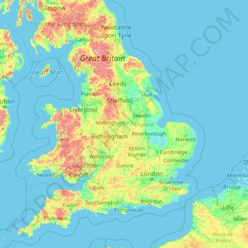
Name: England topographic map, elevation, terrain.
Location: England, United Kingdom (49.67400 -6.70475 55.91700 2.09191)
Average elevation: 180 ft
Minimum elevation: -10 ft
Maximum elevation: 3,169 ft
Other topographic maps
Click on a map to view its topography, its elevation and its terrain.
United Kingdom
Scotland accounts for just under a third (32 per cent) of the total area of the UK, covering 78,772 square kilometres (30,410 sq mi). This includes nearly eight hundred islands, predominantly west and north of the mainland; notably the Hebrides, Orkney Islands and Shetland Islands. Scotland is the most…
Average elevation: 259 ft
Edinburgh
United Kingdom > Scotland > Edinburgh
Some have called Edinburgh the Athens of the North for a variety of reasons. The earliest comparison between the two cities showed that they had a similar topography, with the Castle Rock of Edinburgh performing a similar role to the Athenian Acropolis. Both of them had flatter, fertile agricultural land…
Average elevation: 341 ft
Cambridge
United Kingdom > England > Cambridge
The city, like most of the UK, has a maritime climate highly influenced by the Gulf Stream. Located in the driest region of Britain, Cambridge's rainfall averages around 570 mm (22.44 in) per year, around half the national average, with some years occasionally falling into the semi-arid (under 500 mm (19.69…
Average elevation: 59 ft
Glasgow
United Kingdom > Scotland > Glasgow City
Glasgow itself was reputed to have been founded by the Christian missionary Saint Mungo in the 6th century. He established a church on the Molendinar Burn, where the present Glasgow Cathedral stands, and in the following years Glasgow became a religious centre. Glasgow grew over the following centuries. The…
Average elevation: 420 ft
Richmond
United Kingdom > England > London
The town centre lies just below 33 ft (10m) above sea level. South of the town centre, rising from Richmond Bridge to an elevation of 165 ft (50m), is Richmond Hill. Just beyond the summit of Richmond Hill is Richmond Park, an area of 2,360 acres (9.55 km2; 3.7 sq mi) of wild heath and woodland originally…
Average elevation: 56 ft
Gateshead
United Kingdom > England > Tyne and Wear > Gateshead
One of the most distinguishing features of Gateshead is its topography. The land rises 230 feet (70 m) from Gateshead Quays to the town centre and continues rising to a height of 525 feet (160 m) at Queen Elizabeth Hospital in Sheriff Hill. This is in contrast to the flat and low lying Team Valley located on…
Average elevation: 203 ft
Scottish Highlands
United Kingdom > Scotland > Highland
The entire region was covered by ice sheets during the Pleistocene ice ages, save perhaps for a few nunataks. The complex geomorphology includes incised valleys and lochs carved by the action of mountain streams and ice, and a topography of irregularly distributed mountains whose summits have similar heights…
Average elevation: 2,976 ft
Aberdeen
United Kingdom > Scotland > Aberdeen
Two weather stations collect climate data for the area, Aberdeen/Dyce Airport, and Craibstone. Both are about 4 1⁄2 miles (7 km) to the north west of the city centre, and given that they are in close proximity to each other, exhibit very similar climatic regimes. Dyce tends to have marginally warmer daytime…
Average elevation: 171 ft
Leeds
Lying in the eastern foothills of the Pennines, there is a significant variation in elevation within the city's built-up area. The district ranges from 1,115 feet (340 m) in the far west on the slopes of Ilkley Moor to about 33 feet (10 m) where the rivers Aire and Wharfe cross the eastern boundary. Land rises…
Average elevation: 308 ft
Ben Nevis
United Kingdom > Scotland > Highland
Ben Nevis has a highland (alpine) maritime (oceanic) polar climate (ET climate in the Köppen classification). Ben Nevis's elevation, maritime location and topography frequently lead to cool and cloudy weather conditions, which can pose a danger to ill-equipped walkers. According to the observations carried…
Average elevation: 2,992 ft
Bedford
United Kingdom > England > Bedford
As with the rest of the United Kingdom, Bedford has a maritime climate, with a limited range of temperatures, and generally even rainfall throughout the year. The nearest Met Office weather station to Bedford is Bedford (Thurleigh) airport, about 6.5 miles (10.5 km) north of Bedford town centre at an elevation…
Average elevation: 121 ft
Snowdon
United Kingdom > Wales > Gwynedd
Snowdon (/ˈsnoʊdən/) or Yr Wyddfa (pronounced [ər ˈʊɨ̞̯ðva] (listen)), is the highest mountain in Wales, at an elevation of 1,085 metres (3,560 ft) above sea level, and the highest point in the British Isles outside the Scottish Highlands. It is located in Snowdonia National Park (Parc Cenedlaethol…
Average elevation: 2,270 ft
Portsmouth
United Kingdom > England > Hampshire > Portsmouth
By road, Portsmouth lies 73.5 miles (118.3 km) from Central London, 49.5 miles (79.7 km) west of Brighton, and 22.3 miles (35.9 km) east of Southampton. Portsmouth is situated primarily on Portsea Island and is the United Kingdom's only island city, although parts of it have expanded onto the mainland. Gosport…
Average elevation: 92 ft
Ely
United Kingdom > England > Ely
For over 800 years the cathedral and its associated buildings—built on an elevation 68 feet (21 m) above the nearby fens—have visually influenced the city and its surrounding area. Geographer John Jones, writing in 1924, reports that "from the roof of King's Chapel in Cambridge, on a clear day, Ely can be…
Average elevation: 43 ft
St Albans
United Kingdom > England > Hertfordshire > St Albans
St Albans was an ancient borough created following the dissolution of the monastery in 1539. It consisted of the ancient parish of St Albans (also known as the Abbey parish) and parts of St Michael and St Peter. The municipal corporation was reformed by the Municipal Corporations Act 1835 and the boundary was…
Average elevation: 328 ft
Skiddaw
United Kingdom > England > Cumberland
Skiddaw is a mountain in the Lake District National Park in England. Its 931-metre (3,054 ft) summit is traditionally considered to be the fourth-highest peak but depending on what topographic prominence is thought to be significant is also variously ranked as the third- and the sixth-highest in England. It…
Average elevation: 2,067 ft
Albert Village
United Kingdom > England > Leicestershire > North West Leicestershire
Average elevation: 371 ft
The Roaches
United Kingdom > England > Staffordshire > Staffordshire Moorlands
Average elevation: 1,168 ft
Cwmystwyth Lead Mine Workings
United Kingdom > Wales > Ceredigion > Pontarfynach
Average elevation: 1,322 ft
Knap House Quarry, Birdlip
United Kingdom > England > Gloucestershire > Cotswold District > Birdlip
Average elevation: 728 ft
Weycroft
United Kingdom > England > Devon > East Devon > Axminster > Weycroft
Average elevation: 253 ft
Bradford
Bradford is located at 53°45′00″N 01°50′00″W / 53.75000°N 1.83333°W / 53.75000; -1.83333 (53.7500, -1.8333)1. Topographically, it is located in the eastern moorland region of the South Pennines.
Average elevation: 548 ft
Catherine-de-Barnes
United Kingdom > England > Metropolitan Borough of Solihull > Hampton in Arden
Average elevation: 374 ft
Box Hill
United Kingdom > England > Surrey > Mole Valley > Pixham
The 15.8 km (9.8 mi) Box Hill Olympic circuit is generally cycled in an anticlockwise direction and begins to the south of the village of Mickleham with an ascent of the hill via the Zig Zag Road. From the National Trust Visitor Centre, the route turns eastwards, running along the escarpment and through the…
Average elevation: 344 ft
Littleborough
In the late 18th century, the low-altitude Summit Gap between Littleborough and Walsden was approved as the best route over the Pennines for the Rochdale Canal and the Manchester to Leeds railway; Hollingworth Lake was built at Littleborough's south side as a feeder reservoir to regulate the waters of the…
Average elevation: 873 ft