Geolocate

Centerville topographic map

Click on the map to display elevation.

About this map

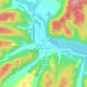
Name: Centerville topographic map, elevation, terrain.

Location: Centerville, Reynolds County, Missouri, 63633, United States (37.42769 -90.96448 37.44543 -90.95577)

Average elevation: 860 ft

Minimum elevation: 719 ft

Maximum elevation: 1,086 ft

Reynolds County trails, hiking, mountain biking, running and outdoor activities

Other topographic maps

Click on a map to view its topography, its elevation and its terrain.

Black

United States > Missouri > Reynolds County

Average elevation: 883 ft

Garwood

United States > Missouri > Reynolds County

Average elevation: 823 ft

Greeley

United States > Missouri > Reynolds County > Greeley

Average elevation: 1,115 ft

Corridon

United States > Missouri > Reynolds County

Average elevation: 1,158 ft

Bear Mountain

United States > Missouri > Reynolds County

Average elevation: 725 ft

Gear up for your next adventure:

📦Dry Bags Set - Waterproof storage for electronics and clothes
🗺️Topographic Maps - Detailed topo maps for hiking, exploring and outdoor navigation
🪵Folding Camp Saw - Compact saw for wood and campsite work
🛌Ultralight Sleeping Bags - Compact down bags for cold nights in the wilderness
🎒Day Hiking Backpack - Lightweight backpack perfect for day trips and outdoor adventures

As an Amazon Associate, this site earns from qualifying purchases at no extra cost to you.