
Mindoro topographic map
Click on the map to display elevation.
Mindoro
Mindoro is the seventh largest and eighth-most populous island in the Philippines. With a total land area of 10,571 km2 ( 4,082 sq.mi ), it has a population of 1,430,921, as of the 2024 census. It is located off the southwestern coast of Luzon and northeast of Palawan. Mindoro is divided into two provinces: Occidental Mindoro and Oriental Mindoro. Calapan is the only city on the island and largest settlement on the island with a total population of 148,558 inhabitants as of 2024. The southern coast of Mindoro forms the northeastern extremum of the Sulu Sea. Mount Halcon is the highest point on the island, standing at 8,484 feet (2,586 m) above sea level located in Oriental Mindoro. Mount Baco is the island's second highest mountain with an elevation of 8,163 feet (2,488 m), located in the province of Occidental Mindoro.
About this map
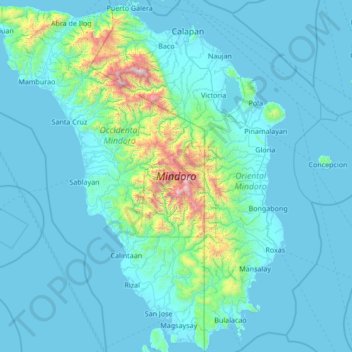
Name: Mindoro topographic map, elevation, terrain.
Location: Mindoro, Occidental Mindoro, Mimaropa, Philippines (12.20770 120.29872 13.53087 121.55861)
Average elevation: 568 ft
Minimum elevation: -7 ft
Maximum elevation: 8,307 ft
Other topographic maps
Click on a map to view its topography, its elevation and its terrain.
Cabra Island
Philippines > Occidental Mindoro > Lubang
With a length of about 4.5 km (2.8 miles) and about 2.9 km (1.8 miles) at its widest, the island has a flat terrain with the highest elevation at 60.96 metres (around 200 feet). A particular rock islet near one beach is considered by locals as a symbol of the island given its shape as a cabra (Spanish for…
Average elevation: 56 ft
Wawa Lighthouse
Philippines > Occidental Mindoro > Abra de Ilog > Lumang Bayan
Average elevation: 85 ft