Geolocate

Tom Bean topographic map

Click on the map to display elevation.

About this map

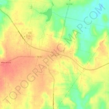
Name: Tom Bean topographic map, elevation, terrain.

Location: Tom Bean, Grayson County, Texas, 75489, United States (33.49829 -96.51028 33.54234 -96.45127)

Average elevation: 778 ft

Minimum elevation: 659 ft

Maximum elevation: 860 ft

Grayson County trails, hiking, mountain biking, running and outdoor activities

Other topographic maps

Click on a map to view its topography, its elevation and its terrain.

Preston

United States > Texas > Grayson County

Average elevation: 633 ft

Mills

United States > Texas > Grayson County > Denison

Average elevation: 682 ft

Sandusky

United States > Texas > Grayson County

Average elevation: 722 ft

Van Alstyne

United States > Texas > Grayson County > Van Alstyne

Average elevation: 738 ft

Howe

United States > Texas > Grayson County

Howe's elevation of 860 feet (260 m) is the highest point along US 75 between the Red River and the Gulf of Mexico.

Average elevation: 814 ft

Bells

United States > Texas > Grayson County

Average elevation: 666 ft

Pottsboro

United States > Texas > Grayson County

Average elevation: 741 ft

Cannon

United States > Texas > Grayson County

Average elevation: 725 ft

Gear up for your next adventure:

🎒Hydration Pack - Hands‑free water reservoir for long hikes
🌡️Portable Weather Meter - Track weather conditions on the trail
🧭Pro Hiking Compasses - High-accuracy liquid-filled compasses for topographic orientation
🚪Portable Camp Chair - Foldable chair for comfort at camp
🪶Wildlife Field Guides - Learn animal tracking and species ID

As an Amazon Associate, this site earns from qualifying purchases at no extra cost to you.