Geolocate

Bells topographic map

Click on the map to display elevation.

About this map

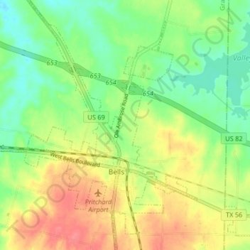
Name: Bells topographic map, elevation, terrain.

Location: Bells, Grayson County, Texas, United States (33.59330 -96.44502 33.64820 -96.38920)

Average elevation: 666 ft

Minimum elevation: 574 ft

Maximum elevation: 781 ft

Grayson County trails, hiking, mountain biking, running and outdoor activities

Other topographic maps

Click on a map to view its topography, its elevation and its terrain.

Preston

United States > Texas > Grayson County

Average elevation: 633 ft

Tom Bean

United States > Texas > Grayson County

Average elevation: 778 ft

Mills

United States > Texas > Grayson County > Denison

Average elevation: 682 ft

Sandusky

United States > Texas > Grayson County

Average elevation: 722 ft

Van Alstyne

United States > Texas > Grayson County > Van Alstyne

Average elevation: 738 ft

Cannon

United States > Texas > Grayson County

Average elevation: 725 ft

Collinsville

United States > Texas > Grayson County > Collinsville

Average elevation: 725 ft

Whitewright

United States > Texas > Grayson County > Whitewright

Average elevation: 755 ft

Gear up for your next adventure:

📻Weather Alert Radios - Stay informed of storm risks while off-the-grid
👓Polarized Sunglasses - Outdoor sunglasses for glare reduction
🧭Outdoor Navigation Book - Learn advanced navigation skills
📦Dry Bags Set - Waterproof storage for electronics and clothes
🥘Titanium Cookware - Durable, featherlight pots and pans for backpacking

As an Amazon Associate, this site earns from qualifying purchases at no extra cost to you.