Geolocate

Howe topographic map

Click on the map to display elevation.

Howe

Howe's elevation of 860 feet (260 m) is the highest point along US 75 between the Red River and the Gulf of Mexico.

Wikipedia (CC-BY-SA 3.0)

About this map

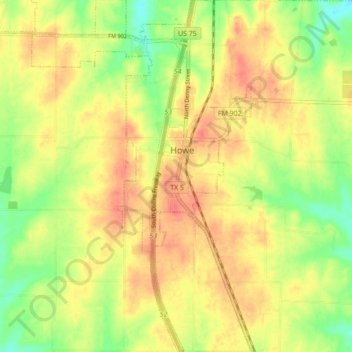
Name: Howe topographic map, elevation, terrain.

Location: Howe, Grayson County, Texas, 75459, United States (33.46537 -96.65025 33.53849 -96.59389)

Average elevation: 814 ft

Minimum elevation: 715 ft

Maximum elevation: 883 ft

Grayson County trails, hiking, mountain biking, running and outdoor activities

Other topographic maps

Click on a map to view its topography, its elevation and its terrain.

Preston

United States > Texas > Grayson County

Average elevation: 633 ft

Tom Bean

United States > Texas > Grayson County

Average elevation: 778 ft

Mills

United States > Texas > Grayson County > Denison

Average elevation: 682 ft

Sandusky

United States > Texas > Grayson County

Average elevation: 722 ft

Van Alstyne

United States > Texas > Grayson County > Van Alstyne

Average elevation: 738 ft

Collinsville

United States > Texas > Grayson County > Collinsville

Average elevation: 725 ft

Cannon

United States > Texas > Grayson County

Average elevation: 725 ft

Whitewright

United States > Texas > Grayson County > Whitewright

Average elevation: 755 ft

Gear up for your next adventure:

🪶Paracord Bracelet - Survival bracelet with built‑in tools
Backpacking Tents - Weight-optimized shelters for multi-day topographic surveys
🕶️GPS Smartphone Mount - Secure mount for phone navigation
📷Action Cameras - Rugged cameras to document your journeys across rugged terrain
🧭Outdoor Navigation Book - Learn advanced navigation skills

As an Amazon Associate, this site earns from qualifying purchases at no extra cost to you.