
Tripura topographic map
Interactive map
Click on the map to display elevation.
About this map
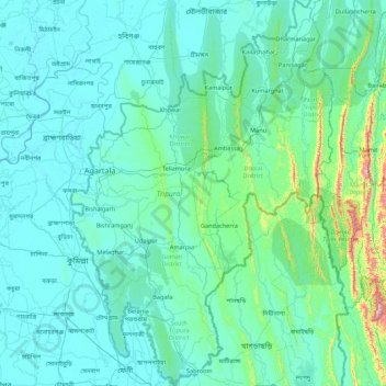
Name: Tripura topographic map, elevation, terrain.
Location: Tripura, India (22.93761 91.15081 24.53088 92.33585)
Average elevation: 279 ft
Minimum elevation: 0 ft
Maximum elevation: 4,331 ft
The physiography is characterised by hill ranges, valleys and plains. The state has five anticlinal ranges of hills running north to south, from Baramura in the west, through Atharamura, Longtharai and Shakhan, to the Jampui Hills in the east. The intervening synclines are the Agartala–Udaipur, Khowai–Teliamura, Kamalpur–Ambasa, Kailasahar–Manu and Dharmanagar–Kanchanpur valleys. At an altitude of 939 m (3,081 ft), Betling Shib in the Jampui range is the state's highest point. The small isolated hillocks interspersed throughout the state are known as tillas, and the narrow fertile alluvial valleys, mostly present in the west, are called Doóng/lungas. A number of rivers originate in the hills of Tripura and flow into Bangladesh. The Khowai, Dhalai, Manu, Juri and Longai flow towards the north; the Gumti to the west; and the Muhuri and Feni to the south west.
Other topographic maps
Click on a map to view its topography, its elevation and its terrain.
3d
India > Rajasthan > Ganganagar Tehsil > 1 LNP
3d, 1 LNP, Ganganagar Tehsil, Sri Ganganagar District, Rajasthan, India
Average elevation: 584 ft
Singahalli
India > Karnataka > Kolar taluk
Singahalli, Kolar taluk, Kolar District, Karnataka, India
Average elevation: 2,799 ft
Elimukku
India > Kerala > Kozhencherry
Elimukku, Kozhencherry, Pathanamthitta District, Kerala, 689504, India
Average elevation: 95 ft
Rohru
Rohru, Shimla District, Himachal Pradesh, 171207, India
Average elevation: 7,474 ft
Tral
Tral, Pulwama District, Jammu and Kashmir, 192123, India
Average elevation: 8,294 ft
Panner Jageer
India > Jammu and Kashmir > Tral
Panner Jageer, Tral, Pulwama District, Jammu and Kashmir, India
Average elevation: 6,631 ft
Malappuram
Malappuram, Ernad, Malappuram District, Kerala, India
Average elevation: 184 ft
Taiba
India > Jharkhand > Erki(Tamar II)
Taiba, Erki(Tamar II), Khunti District, Jharkhand, India
Average elevation: 1,850 ft
Surat
India > Gujarat > Katargam Taluka
Surat, Katargam Taluka, Surat District, Gujarat, 395008, India
Average elevation: 43 ft
Ameenpur mandal
Ameenpur mandal, Sangareddy District, Telangana, India
Average elevation: 1,811 ft
Sreekandapuram
India > Kerala > Taliparamba
Sreekandapuram, Taliparamba, Kannur District, Kerala, 670631, India
Average elevation: 230 ft
Kulana
India > Punjab > Budhlada Tahsil
Kulana, Budhlada Tahsil, Mansa District, Punjab, India
Average elevation: 725 ft
Hukkeri
India > Karnataka > Hukkeri taluk
Hukkeri, Hukkeri taluk, Karnataka, 591309, India
Average elevation: 2,162 ft
Patauda
India > Madhya Pradesh > Unchahara Tahsil
Patauda, Unchahara Tahsil, Satna District, Madhya Pradesh, India
Average elevation: 1,106 ft
Sector 37D
India > Haryana > Gurugram District
Sector 37D, Gurgaon, Gurugram District, Haryana, India
Average elevation: 712 ft
Nakrekal
India > Telangana > Nakrekal mandal
Nakrekal, Nakrekal mandal, Nalgonda District, Telangana, 508211, India
Average elevation: 679 ft
Manjavadi
India > Tamil Nadu > Kilvelur > Anaimangalam
Manjavadi, Anaimangalam, Kilvelur, Nagapattinam District, Tamil Nadu, 611104, India
Average elevation: 16 ft
Lal Kuan
India > Uttar Pradesh > Ghaziabad
Lal Kuan, Ghaziabad, Ghaziabad District, Uttar Pradesh, 201016, India
Average elevation: 692 ft
Chandupatla
India > Telangana > Maddirala mandal
Chandupatla, Maddirala mandal, Suryapet District, Telangana, India
Average elevation: 633 ft
Sengipatti
India > Tamil Nadu > Thanjavur
Sengipatti, Thanjavur, Thanjavur District, Tamil Nadu, India
Average elevation: 259 ft
Dehradun
India > Uttarakhand > Dehradun
Dehradun, Dehradun District, Uttarakhand, 248001, India
Average elevation: 2,966 ft
Ramchandrapuram
India > Andhra Pradesh > A.Konduru
Ramchandrapuram, A.Konduru, NTR, Andhra Pradesh, India
Average elevation: 322 ft
Simandhar Tenements & Flats
India > Gujarat > Mahesana Taluka
Simandhar Tenements & Flats, Mahesana Taluka, Mahesana District, Gujarat, 384001, India
Average elevation: 285 ft
Kadungalloor
India > Kerala > Paravur > Edayar
Kadungalloor, Edayar, Paravur, Ernakulam District, Kerala, India
Average elevation: 26 ft
Shast
India > Himachal Pradesh > Kotkhai
Shast, Kotkhai, Shimla District, Himachal Pradesh, 171204, India
Average elevation: 7,516 ft
Haraluru
India > Karnataka > Tumkur taluk
Haraluru, Tumkur taluk, Tumakuru District, Karnataka, India
Average elevation: 2,835 ft
Shivpuri District
Shivpuri District, Madhya Pradesh, India
Average elevation: 1,184 ft
Duldula
India > Chhattisgarh > Duldula Tahsil
Duldula, Duldula Tahsil, Jashpur District, Chhattisgarh, 496334, India
Average elevation: 1,739 ft
Jodhpur
India > Rajasthan > Jodhpur Tehsil
Jodhpur, Jodhpur Tehsil, Jodhpur District, Rajasthan, India
Average elevation: 781 ft
Boroonda
India > Rajasthan > Pipar City Tehsil
Boroonda, Pipar City Tehsil, Jodhpur(Rural) District, Rajasthan, India
Average elevation: 1,004 ft
Gubbalala
India > Karnataka > Bangalore South
Gubbalala, Bangalore South, Bengaluru Urban, Karnataka, 560062, India
Average elevation: 2,871 ft
Gairan Wasti
India > Maharashtra > Dharashiv > Waruda
Gairan Wasti, Waruda, Dharashiv, Dharashiv District, Maharashtra, India
Average elevation: 2,175 ft
Indian subcontinent
India > Maharashtra > Arni
Indian subcontinent, Arni, Yavatmal, Maharashtra, India
Average elevation: 1,155 ft
Shadnagar
India > Telangana > Farooqnagar mandal
Shadnagar, Farooqnagar mandal, Ranga Reddy District, Telangana, 509216, India
Average elevation: 2,073 ft
Tamluk
Tamluk, Purba Medinipur District, West Bengal, India
Average elevation: 13 ft
Digdoh
India > Maharashtra > Nagpur Urban Taluka
Digdoh, Nagpur Urban Taluka, Nagpur District, Maharashtra, 440019, India
Average elevation: 1,070 ft
Sonbhadra
India > Bihar > Sonbhadra Banshi Suryapur
Sonbhadra, Sonbhadra Banshi Suryapur, Arwal District, Bihar, 824120, India
Average elevation: 243 ft
Sulai
India > Rajasthan > Kherwara Tehsil
Sulai, Kherwara Tehsil, Udaipur District, Rajasthan, India
Average elevation: 1,296 ft
Nipani
India > Maharashtra > Chhatrapati Sambhajinagar
Nipani, Chhatrapati Sambhajinagar, Chhatrapati Sambhajinagar District, Maharashtra, 431007, India
Average elevation: 1,837 ft
Neamatpur
India > West Bengal > Goalpokhar - II
Neamatpur, Goalpokhar - II, Uttar Dinajpur District, West Bengal, India
Average elevation: 131 ft