
Make a donation
Gear up for your next adventure:
As an Amazon Associate, this site earns from qualifying purchases at no extra cost to you.
Capitol Planning Region topographic map
Click on the map to display elevation.
Make a donation
Gear up for your next adventure:
As an Amazon Associate, this site earns from qualifying purchases at no extra cost to you.
About this map
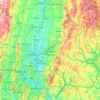
Name: Capitol Planning Region topographic map, elevation, terrain.
Location: Capitol Planning Region, Connecticut, United States (41.54471 -72.95433 42.03753 -72.15632)
Average elevation: 404 ft
Minimum elevation: -3 ft
Maximum elevation: 1,421 ft
Connecticut trails, hiking, mountain biking, running and outdoor activities
Make a donation
Gear up for your next adventure:
As an Amazon Associate, this site earns from qualifying purchases at no extra cost to you.
Other topographic maps
Click on a map to view its topography, its elevation and its terrain.
Johnsonville
United States > Connecticut > Lower Connecticut River Valley Planning Region > East Haddam
Average elevation: 190 ft
Apple Hill
United States > Connecticut > Northwest Hills Planning Region > Morris
Average elevation: 974 ft
Make a donation
Gear up for your next adventure:
As an Amazon Associate, this site earns from qualifying purchases at no extra cost to you.
Sea Bluff
United States > Connecticut > South Central Connecticut Planning Region > West Haven > West Shore
Average elevation: 46 ft
West Suffield
United States > Connecticut > Capitol Planning Region > Suffield
Average elevation: 194 ft
Plantsville
United States > Connecticut > Capitol Planning Region > Southington
Average elevation: 187 ft
Make a donation
Gear up for your next adventure:
As an Amazon Associate, this site earns from qualifying purchases at no extra cost to you.
Northfield
United States > Connecticut > Northwest Hills Planning Region > Litchfield
Average elevation: 850 ft
Huntington
United States > Connecticut > Naugatuck Valley Planning Region > Shelton
Average elevation: 364 ft
Old Greenwich
United States > Connecticut > Western Connecticut Planning Region > Greenwich
Average elevation: 39 ft
Hamburg
United States > Connecticut > Lower Connecticut River Valley Planning Region > Lyme
Average elevation: 161 ft
Make a donation
Gear up for your next adventure:
As an Amazon Associate, this site earns from qualifying purchases at no extra cost to you.
Bakerville
United States > Connecticut > Northwest Hills Planning Region > New Hartford
Average elevation: 801 ft
Haystack Mountain
United States > Connecticut > Northwest Hills Planning Region > Norfolk
Average elevation: 1,263 ft
Laysville
United States > Connecticut > Lower Connecticut River Valley Planning Region > Old Lyme
Average elevation: 108 ft
High Rock
United States > Connecticut > Southeastern Connecticut Planning Region > Waterford
Average elevation: 128 ft
Make a donation
Gear up for your next adventure:
As an Amazon Associate, this site earns from qualifying purchases at no extra cost to you.
Fenwood
United States > Connecticut > Lower Connecticut River Valley Planning Region > Old Saybrook
Average elevation: 7 ft
Four Corners
United States > Connecticut > Capitol Planning Region > Terramuggus
Average elevation: 469 ft
Chesterfield
United States > Connecticut > Southeastern Connecticut Planning Region > Montville
Average elevation: 253 ft
Hadlyme
United States > Connecticut > Lower Connecticut River Valley Planning Region > Lyme
Average elevation: 148 ft
Make a donation
Gear up for your next adventure:
As an Amazon Associate, this site earns from qualifying purchases at no extra cost to you.
Minortown
United States > Connecticut > Naugatuck Valley Planning Region > Woodbury
Average elevation: 554 ft
Mount Higby
United States > Connecticut > Lower Connecticut River Valley Planning Region > Middletown
Average elevation: 440 ft
Marble Dale
United States > Connecticut > Northwest Hills Planning Region > Washington
Average elevation: 817 ft
Washington Depot
United States > Connecticut > Northwest Hills Planning Region > Washington
Average elevation: 758 ft
Make a donation
Gear up for your next adventure:
As an Amazon Associate, this site earns from qualifying purchases at no extra cost to you.
Killingworth Court
United States > Connecticut > South Central Connecticut Planning Region > New Haven
Average elevation: 43 ft
Hein Trails
United States > Connecticut > South Central Connecticut Planning Region > Bethany > Davidsons Corner
Average elevation: 574 ft
Nelsons Corner
United States > Connecticut > Northwest Hills Planning Region > Winchester
Average elevation: 902 ft
Indian Neck
United States > Connecticut > South Central Connecticut Planning Region > Branford
Average elevation: 13 ft
Make a donation
Gear up for your next adventure:
As an Amazon Associate, this site earns from qualifying purchases at no extra cost to you.
Nepaug
United States > Connecticut > Northwest Hills Planning Region > New Hartford
Average elevation: 728 ft
Northford
United States > Connecticut > South Central Connecticut Planning Region > North Branford
Average elevation: 233 ft
Lakeville
United States > Connecticut > Northwest Hills Planning Region > Salisbury
Average elevation: 850 ft
Ansonia
United States > Connecticut > South Central Connecticut Planning Region
Average elevation: 364 ft
Make a donation
Gear up for your next adventure:
As an Amazon Associate, this site earns from qualifying purchases at no extra cost to you.
Sandy Hook
United States > Connecticut > Western Connecticut Planning Region > Newtown
Average elevation: 371 ft
North Franklin
United States > Connecticut > Southeastern Connecticut Planning Region
Average elevation: 338 ft
East Morris
United States > Connecticut > Northwest Hills Planning Region > Morris
Average elevation: 965 ft
Mystic
United States > Connecticut > Southeastern Connecticut Planning Region
Average elevation: 79 ft
Make a donation
Gear up for your next adventure:
As an Amazon Associate, this site earns from qualifying purchases at no extra cost to you.
Candlewood Lake Club
United States > Connecticut > Western Connecticut Planning Region > New Milford
Average elevation: 469 ft
Cannondale
United States > Connecticut > Western Connecticut Planning Region > Wilton
Average elevation: 361 ft
Oronoque
United States > Connecticut > Greater Bridgeport Planning Region > Stratford
Average elevation: 121 ft
Southport
United States > Connecticut > Greater Bridgeport Planning Region > Fairfield
Average elevation: 36 ft
Make a donation
Gear up for your next adventure:
As an Amazon Associate, this site earns from qualifying purchases at no extra cost to you.
Taylor Corners
United States > Connecticut > Western Connecticut Planning Region > New Fairfield
Average elevation: 741 ft
Mianus
United States > Connecticut > Western Connecticut Planning Region > Greenwich
Average elevation: 75 ft
Willington Hill
United States > Connecticut > Capitol Planning Region > Willington
Average elevation: 646 ft
Wangum Village
United States > Connecticut > Northwest Hills Planning Region > Canaan
Average elevation: 771 ft
Make a donation
Gear up for your next adventure:
As an Amazon Associate, this site earns from qualifying purchases at no extra cost to you.
Vernon Center
United States > Connecticut > Capitol Planning Region > Vernon
Average elevation: 348 ft
Derby
United States > Connecticut > South Central Connecticut Planning Region
According to the United States Census Bureau, the town has a total area of 5.4 square miles (8.7 km2), of which, 5.0 square miles (13 km2) is land and 0.4 square miles (1.0 km2) (7.41%) is water. The city is home to the 417 acres (0.652 sq mi) Osbornedale State Park. Derby is divided into two main sections by…
Average elevation: 259 ft
Winnipauk
United States > Connecticut > Western Connecticut Planning Region > Norwalk
Average elevation: 167 ft
West Norwalk
United States > Connecticut > Western Connecticut Planning Region > Norwalk
Average elevation: 164 ft
Make a donation
Gear up for your next adventure:
As an Amazon Associate, this site earns from qualifying purchases at no extra cost to you.
Flanders
United States > Connecticut > Southeastern Connecticut Planning Region > East Lyme
Average elevation: 141 ft
Godfrey Corner
United States > Connecticut > Western Connecticut Planning Region > Weston
Average elevation: 361 ft
Manitock Spring
United States > Connecticut > Southeastern Connecticut Planning Region > Waterford
Average elevation: 85 ft
Make a donation
Gear up for your next adventure:
As an Amazon Associate, this site earns from qualifying purchases at no extra cost to you.
Pleasant Valley
United States > Connecticut > Northwest Hills Planning Region > Barkhamsted
Average elevation: 630 ft
Skinnerville
United States > Connecticut > Lower Connecticut River Valley Planning Region > East Hampton
Average elevation: 430 ft
Griswoldville
United States > Connecticut > Capitol Planning Region > Wethersfield
Average elevation: 112 ft
Quiambaug
United States > Connecticut > Southeastern Connecticut Planning Region > Mystic
Average elevation: 26 ft
Make a donation
Gear up for your next adventure:
As an Amazon Associate, this site earns from qualifying purchases at no extra cost to you.
Killingly Center
United States > Connecticut > Northeastern Connecticut Planning Region > Killingly > Dayville
Average elevation: 358 ft
Oakdale
United States > Connecticut > Southeastern Connecticut Planning Region > Montville
Average elevation: 463 ft
Clay Arsenal
United States > Connecticut > Capitol Planning Region > Hartford
Average elevation: 59 ft
Momauguin
United States > Connecticut > South Central Connecticut Planning Region > East Haven
Average elevation: 10 ft
Make a donation
Gear up for your next adventure:
As an Amazon Associate, this site earns from qualifying purchases at no extra cost to you.
Austrailia Beach
United States > Connecticut > Southeastern Connecticut Planning Region > Mystic
Average elevation: 62 ft
Jordan Village
United States > Connecticut > Southeastern Connecticut Planning Region > Waterford
Average elevation: 89 ft
Brockway
United States > Connecticut > Lower Connecticut River Valley Planning Region > Lyme
Average elevation: 154 ft
Giants Neck
United States > Connecticut > Southeastern Connecticut Planning Region > East Lyme
Average elevation: 30 ft
Make a donation
Gear up for your next adventure:
As an Amazon Associate, this site earns from qualifying purchases at no extra cost to you.
Drakeville
United States > Connecticut > Northwest Hills Planning Region > Torrington
Average elevation: 1,014 ft
North Mianus
United States > Connecticut > Western Connecticut Planning Region > Greenwich
Average elevation: 105 ft
Saugatuck
United States > Connecticut > Western Connecticut Planning Region > Westport
Average elevation: 49 ft
North End
United States > Connecticut > Capitol Planning Region > Southington
Average elevation: 223 ft
Make a donation
Gear up for your next adventure:
As an Amazon Associate, this site earns from qualifying purchases at no extra cost to you.
Indian Cave
United States > Connecticut > South Central Connecticut Planning Region > Guilford
Average elevation: 82 ft
Five Points
United States > Connecticut > Western Connecticut Planning Region > Redding Ridge
Average elevation: 607 ft
Daniels Mill
United States > Connecticut > Western Connecticut Planning Region > New Canaan
Average elevation: 328 ft
White Hills
United States > Connecticut > Naugatuck Valley Planning Region > Shelton
Average elevation: 407 ft
Make a donation
Gear up for your next adventure:
As an Amazon Associate, this site earns from qualifying purchases at no extra cost to you.
Thomas Mountain
United States > Connecticut > Western Connecticut Planning Region > Danbury
Average elevation: 646 ft
Central Village
United States > Connecticut > Northeastern Connecticut Planning Region > Plainfield
Average elevation: 226 ft
Chaffeeville
United States > Connecticut > Capitol Planning Region > Mansfield
Average elevation: 436 ft
West District
United States > Connecticut > Capitol Planning Region > Farmington
Average elevation: 302 ft
Make a donation
Gear up for your next adventure:
As an Amazon Associate, this site earns from qualifying purchases at no extra cost to you.
Lookout
United States > Connecticut > Northwest Hills Planning Region > Goshen
Average elevation: 1,424 ft
Talcott Mountain
United States > Connecticut > Capitol Planning Region > Bloomfield
Average elevation: 499 ft
North Madison
United States > Connecticut > South Central Connecticut Planning Region > Madison
Average elevation: 299 ft
Bartholomew Hill
United States > Connecticut > Northwest Hills Planning Region > Goshen
Average elevation: 1,398 ft
Make a donation
Gear up for your next adventure:
As an Amazon Associate, this site earns from qualifying purchases at no extra cost to you.
South Wethersfield
United States > Connecticut > Capitol Planning Region > Wethersfield > Griswoldville
Average elevation: 72 ft
Nut Plains
United States > Connecticut > South Central Connecticut Planning Region > Guilford
Average elevation: 115 ft
Fort Trumbull
United States > Connecticut > South Central Connecticut Planning Region > Milford
Average elevation: 23 ft
Make a donation
Gear up for your next adventure:
As an Amazon Associate, this site earns from qualifying purchases at no extra cost to you.
Germantown
United States > Connecticut > Western Connecticut Planning Region > Danbury
Average elevation: 397 ft
South End Point
United States > Connecticut > South Central Connecticut Planning Region > East Haven > Momauguin
Average elevation: 7 ft
Pinneys Corners
United States > Connecticut > Western Connecticut Planning Region > New Canaan
Average elevation: 469 ft
Branford Court
United States > Connecticut > South Central Connecticut Planning Region > New Haven
Average elevation: 43 ft
Make a donation
Gear up for your next adventure:
As an Amazon Associate, this site earns from qualifying purchases at no extra cost to you.
Canaan Valley
United States > Connecticut > Northwest Hills Planning Region > North Canaan
Average elevation: 961 ft
Buckingham
United States > Connecticut > Capitol Planning Region > Glastonbury
Average elevation: 430 ft
Riverside
United States > Connecticut > Western Connecticut Planning Region > Greenwich > Old Greenwich
Average elevation: 43 ft
North Coventry
United States > Connecticut > Capitol Planning Region > Coventry
Average elevation: 640 ft
Make a donation
Gear up for your next adventure:
As an Amazon Associate, this site earns from qualifying purchases at no extra cost to you.
Beaver Brook
United States > Connecticut > Western Connecticut Planning Region > Danbury
Average elevation: 390 ft
West Shore
United States > Connecticut > South Central Connecticut Planning Region > West Haven
Average elevation: 30 ft
North Haven Bridge
United States > Connecticut > South Central Connecticut Planning Region > North Haven
Average elevation: 72 ft
Make a donation
Gear up for your next adventure:
As an Amazon Associate, this site earns from qualifying purchases at no extra cost to you.
Lake Whitney
United States > Connecticut > South Central Connecticut Planning Region > Hamden > Whitneyville
Average elevation: 82 ft
Lake Whitney
United States > Connecticut > South Central Connecticut Planning Region > Hamden
Average elevation: 82 ft
Pepperbox Hill
United States > Connecticut > Southeastern Connecticut Planning Region > Waterford
Average elevation: 59 ft
Make a donation
Gear up for your next adventure:
As an Amazon Associate, this site earns from qualifying purchases at no extra cost to you.