
Perímetro Urbano Neiva topographic map
Interactive map
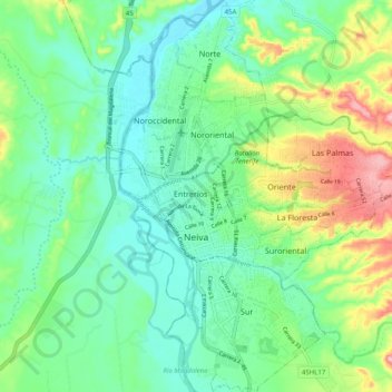
Click on the map to display elevation.
About this map
Name: Perímetro Urbano Neiva topographic map, elevation, terrain.
Average elevation: 1,539 ft
Minimum elevation: 1,375 ft
Maximum elevation: 1,936 ft
Due to its location near the equator and its low altitude, the city has a hot annual average climate with daytime temperatures ranging from 88 to 95 degrees Fahrenheit. It is about 300 kilometers / 186.4 miles (about a five-hour drive) from the Colombian capital, Bogotá.
Other topographic maps
Click on a map to view its topography, its elevation and its terrain.
Reserva Natural de la Sociedad Civil La Esperanza
Reserva Natural de la Sociedad Civil La Esperanza, Neiva, Norte, Huila, RAP (Especial) Central, Colombia
Average elevation: 4,721 ft
Carmen De Bolívar
Colombia > Huila > Santa María
Carmen De Bolívar, Santa María, Norte, Huila, RAP (Especial) Central, Colombia
Average elevation: 8,517 ft
Santa María
Santa María, Norte, Huila, RAP (Especial) Central, Colombia
Average elevation: 6,115 ft
San Augustin
San Augustin, Colombia, Norte, Huila, Colombia
Average elevation: 5,440 ft
Campoalegre
Campoalegre, Norte, Huila, RAP (Especial) Central, Colombia
Average elevation: 3,488 ft
Buenos Aires
Buenos Aires, Palermo, Norte, Huila, Colombia
Average elevation: 2,628 ft
Salto de Bordones
Salto de Bordones, Isnos, Sur, Huila, Colombia
Average elevation: 5,669 ft
Desierto de la Tatacoa
Colombia > Huila > Villavieja
Desierto de la Tatacoa, Villavieja, Norte, Huila, Colombia
Average elevation: 1,470 ft
Nueva Irlanda
Nueva Irlanda, La Plata, Occidente, Huila, Colombia
Average elevation: 5,354 ft