
Make a donation
Gear up for your next adventure:
As an Amazon Associate, this site earns from qualifying purchases at no extra cost to you.
Yaguará topographic map
Click on the map to display elevation.
Make a donation
Gear up for your next adventure:
As an Amazon Associate, this site earns from qualifying purchases at no extra cost to you.
Yaguará
Yaguará (Spanish pronunciation: [ɟʝaɣwaˈɾa]) is a town and municipality in the Huila Department, Colombia. The urban centre is located at an elevation of 650 metres (2,130 ft) in the Magdalena River Valley and the Eastern Ranges of the Colombian Andes. The municipality borders Teruel and Palermo in the north, Gigante, Hobo and Tesalia in the south, Campoalegre and Hobo in the east and Tesalia and Iquira in the west. The departmental capital Neiva is 49 kilometres (30 mi) to the northeast. The Betania Reservoir is situated within the boundaries of Yaguará.
Make a donation
Gear up for your next adventure:
As an Amazon Associate, this site earns from qualifying purchases at no extra cost to you.
About this map
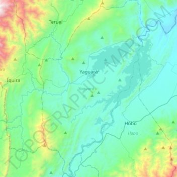
Name: Yaguará topographic map, elevation, terrain.
Location: Yaguará, Norte, Huila, RAP (Especial) Central, Colombia (2.49601 -75.59358 2.77613 -75.41929)
Average elevation: 2,762 ft
Minimum elevation: 1,539 ft
Maximum elevation: 8,537 ft
Make a donation
Gear up for your next adventure:
As an Amazon Associate, this site earns from qualifying purchases at no extra cost to you.
Other topographic maps
Click on a map to view its topography, its elevation and its terrain.
Reserva Natural de la Sociedad Civil La Esperanza
Average elevation: 4,721 ft
Make a donation
Gear up for your next adventure:
As an Amazon Associate, this site earns from qualifying purchases at no extra cost to you.
Altamira
Altamira is a small pueblo in the department Huila, with a population around 2,416. Its geographical coordinates are 2° 3' 46" North, 75° 47' 14" West. It is about an 8-hour bus trip south of Bogota. The largest city in Huila and its capital is Neiva, which is 89 miles north, with a population of about…
Average elevation: 3,386 ft
Make a donation
Gear up for your next adventure:
As an Amazon Associate, this site earns from qualifying purchases at no extra cost to you.