
Make a donation
Gear up for your next adventure:
As an Amazon Associate, this site earns from qualifying purchases at no extra cost to you.
East Farmingdale topographic map
Click on the map to display elevation.
Make a donation
Gear up for your next adventure:
As an Amazon Associate, this site earns from qualifying purchases at no extra cost to you.
About this map
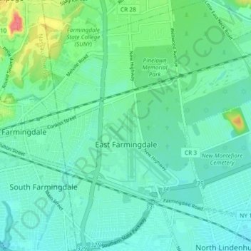
Name: East Farmingdale topographic map, elevation, terrain.
Average elevation: 79 ft
Minimum elevation: 33 ft
Maximum elevation: 243 ft
Suffolk County trails, hiking, mountain biking, running and outdoor activities
Make a donation
Gear up for your next adventure:
As an Amazon Associate, this site earns from qualifying purchases at no extra cost to you.
Other topographic maps
Click on a map to view its topography, its elevation and its terrain.
Stony Brook University
United States > New York > Suffolk County > Town of Brookhaven
Average elevation: 151 ft
East Hampton
United States > New York > Suffolk County > East Hampton > Village of East Hampton
Average elevation: 39 ft
Make a donation
Gear up for your next adventure:
As an Amazon Associate, this site earns from qualifying purchases at no extra cost to you.
Port Jefferson Harbor
United States > New York > Suffolk County > Town of Brookhaven
Average elevation: 33 ft
South Jamesport
United States > New York > Suffolk County > Town of Riverhead > Jamesport
Average elevation: 7 ft
Make a donation
Gear up for your next adventure:
As an Amazon Associate, this site earns from qualifying purchases at no extra cost to you.
West Tiana
United States > New York > Suffolk County > Hampton Bays > Town of Southampton
Average elevation: 26 ft
West Point
United States > New York > Suffolk County > Hampton Bays > Town of Southampton > Rampasture
Average elevation: 10 ft
Sag Harbor
United States > New York > Suffolk County > Sag Harbor > Sag Harbor
Average elevation: 43 ft
Make a donation
Gear up for your next adventure:
As an Amazon Associate, this site earns from qualifying purchases at no extra cost to you.
Port Jefferson
United States > New York > Suffolk County > Port Jefferson > Port Jefferson
It wasn't until 1836 that the local leadership truly initiated the community's transition from a swampish hamlet to a bustling port town. Twenty-two acres of the harborfront, which flooded with the tides, were brought to a stable elevation with the construction of a causeway. Concurrently, the village was…
Average elevation: 85 ft
Setauket
United States > New York > Suffolk County > East Setauket > Setauket
Average elevation: 72 ft
Make a donation
Gear up for your next adventure:
As an Amazon Associate, this site earns from qualifying purchases at no extra cost to you.
Ditch Plains
United States > New York > Suffolk County > Town of East Hampton > Montauk
Average elevation: 16 ft
Wildwood State Park
United States > New York > Suffolk County > Wading River > Wildwood
Average elevation: 92 ft
Westmoreland
United States > New York > Suffolk County > Shelter Island Heights
Average elevation: 13 ft
Make a donation
Gear up for your next adventure:
As an Amazon Associate, this site earns from qualifying purchases at no extra cost to you.
Rampasture
United States > New York > Suffolk County > Hampton Bays > Town of Southampton
Average elevation: 13 ft
Make a donation
Gear up for your next adventure:
As an Amazon Associate, this site earns from qualifying purchases at no extra cost to you.
Lonelyville
United States > New York > Suffolk County > Town of Islip > Fair Harbor
Average elevation: 0 ft
Make a donation
Gear up for your next adventure:
As an Amazon Associate, this site earns from qualifying purchases at no extra cost to you.
Montauk Station
United States > New York > Suffolk County > Town of East Hampton > Montauk
Average elevation: 36 ft
Make a donation
Gear up for your next adventure:
As an Amazon Associate, this site earns from qualifying purchases at no extra cost to you.
Southampton
United States > New York > Suffolk County > Southampton > Southampton
Average elevation: 20 ft
Make a donation
Gear up for your next adventure:
As an Amazon Associate, this site earns from qualifying purchases at no extra cost to you.
East Hauppauge
United States > New York > Suffolk County > Town of Smithtown > Nesconset > East Hauppauge
Average elevation: 92 ft
Make a donation
Gear up for your next adventure:
As an Amazon Associate, this site earns from qualifying purchases at no extra cost to you.
Springville
United States > New York > Suffolk County > Hampton Bays > Town of Southampton
Average elevation: 33 ft
Rose Grove
United States > New York > Suffolk County > North Sea > Town of Southampton
Average elevation: 49 ft
Old Mastic
United States > New York > Suffolk County > Mastic Beach > Town of Brookhaven
Average elevation: 13 ft
Make a donation
Gear up for your next adventure:
As an Amazon Associate, this site earns from qualifying purchases at no extra cost to you.