
Make a donation
Gear up for your next adventure:
As an Amazon Associate, this site earns from qualifying purchases at no extra cost to you.
Long Pond topographic map
Click on the map to display elevation.
Make a donation
Gear up for your next adventure:
As an Amazon Associate, this site earns from qualifying purchases at no extra cost to you.
About this map
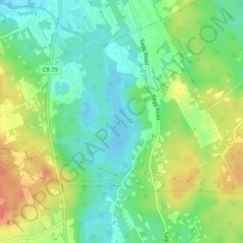
Name: Long Pond topographic map, elevation, terrain.
Location: Long Pond, Suffolk County, New York, United States (40.97131 -72.29600 40.98175 -72.28889)
Average elevation: 66 ft
Minimum elevation: -3 ft
Maximum elevation: 154 ft
Suffolk County trails, hiking, mountain biking, running and outdoor activities
Make a donation
Gear up for your next adventure:
As an Amazon Associate, this site earns from qualifying purchases at no extra cost to you.
Other topographic maps
Click on a map to view its topography, its elevation and its terrain.
Port Jefferson
United States > New York > Suffolk County > Port Jefferson > Port Jefferson
It wasn't until 1836 that the local leadership truly initiated the community's transition from a swampish hamlet to a bustling port town. Twenty-two acres of the harborfront, which flooded with the tides, were brought to a stable elevation with the construction of a causeway. Concurrently, the village was…
Average elevation: 85 ft
Make a donation
Gear up for your next adventure:
As an Amazon Associate, this site earns from qualifying purchases at no extra cost to you.
Bridgehampton
United States > New York > Suffolk County > Town of Southampton
Average elevation: 46 ft
Make a donation
Gear up for your next adventure:
As an Amazon Associate, this site earns from qualifying purchases at no extra cost to you.
East Hampton North
United States > New York > Suffolk County > Town of East Hampton
Average elevation: 52 ft
Stony Brook University
United States > New York > Suffolk County > Town of Brookhaven
Average elevation: 151 ft
Make a donation
Gear up for your next adventure:
As an Amazon Associate, this site earns from qualifying purchases at no extra cost to you.
East Hampton
United States > New York > Suffolk County > East Hampton > Village of East Hampton
Average elevation: 39 ft
Make a donation
Gear up for your next adventure:
As an Amazon Associate, this site earns from qualifying purchases at no extra cost to you.
Port Jefferson Station
United States > New York > Suffolk County > Town of Brookhaven
Average elevation: 157 ft
South Jamesport
United States > New York > Suffolk County > Town of Riverhead > Jamesport
Average elevation: 7 ft
Make a donation
Gear up for your next adventure:
As an Amazon Associate, this site earns from qualifying purchases at no extra cost to you.
Robert Moses State Park (Long Island)
United States > New York > Suffolk County > Town of Islip
Average elevation: 0 ft
Village of Brightwaters
United States > New York > Suffolk County > Town of Islip
Average elevation: 26 ft
Make a donation
Gear up for your next adventure:
As an Amazon Associate, this site earns from qualifying purchases at no extra cost to you.
West Tiana
United States > New York > Suffolk County > Hampton Bays > Town of Southampton
Average elevation: 26 ft
West Point
United States > New York > Suffolk County > Hampton Bays > Town of Southampton > Rampasture
Average elevation: 10 ft
Make a donation
Gear up for your next adventure:
As an Amazon Associate, this site earns from qualifying purchases at no extra cost to you.
Sag Harbor
United States > New York > Suffolk County > Sag Harbor > Sag Harbor
Average elevation: 43 ft
Make a donation
Gear up for your next adventure:
As an Amazon Associate, this site earns from qualifying purchases at no extra cost to you.
Setauket
United States > New York > Suffolk County > East Setauket > Setauket
Average elevation: 72 ft
Village of Belle Terre
United States > New York > Suffolk County > Town of Brookhaven
Average elevation: 66 ft
Make a donation
Gear up for your next adventure:
As an Amazon Associate, this site earns from qualifying purchases at no extra cost to you.
Ditch Plains
United States > New York > Suffolk County > Town of East Hampton > Montauk
Average elevation: 16 ft
Rocky Point Pine Barrens State Forest
United States > New York > Suffolk County > Rocky Point > Town of Brookhaven
Average elevation: 105 ft
Make a donation
Gear up for your next adventure:
As an Amazon Associate, this site earns from qualifying purchases at no extra cost to you.
Middle Island
United States > New York > Suffolk County > Town of Brookhaven
On October 27, 1910, the International Aviation Tournament was held at the Belmont Park racetrack in Elmont, New York. The meet offered $3,750 for the highest altitude, another $1,000 for a world record and a $5,000 bonus for exceeding 10,000 feet. Ralph Johnstone set a new American flight altitude record of…
Average elevation: 102 ft
Westmoreland
United States > New York > Suffolk County > Shelter Island Heights
Average elevation: 13 ft
Make a donation
Gear up for your next adventure:
As an Amazon Associate, this site earns from qualifying purchases at no extra cost to you.
Rampasture
United States > New York > Suffolk County > Hampton Bays > Town of Southampton
Average elevation: 13 ft
Make a donation
Gear up for your next adventure:
As an Amazon Associate, this site earns from qualifying purchases at no extra cost to you.
East Patchogue
United States > New York > Suffolk County > Town of Brookhaven
Average elevation: 33 ft
Quiogue
United States > New York > Suffolk County
Quiogue is located at 40°49′11″N 072°37′44″W / 40.81972°N 72.62889°W / 40.81972; -72.62889 (40.8198217, -72.6289837) and its elevation is 23 feet (7 m).
Average elevation: 16 ft
Make a donation
Gear up for your next adventure:
As an Amazon Associate, this site earns from qualifying purchases at no extra cost to you.
North Lindenhurst
United States > New York > Suffolk County > Town of Babylon
Average elevation: 46 ft
Make a donation
Gear up for your next adventure:
As an Amazon Associate, this site earns from qualifying purchases at no extra cost to you.
Lonelyville
United States > New York > Suffolk County > Town of Islip > Fair Harbor
Average elevation: 0 ft
Village of Huntington Bay
United States > New York > Suffolk County > Town of Huntington
Average elevation: 52 ft
Make a donation
Gear up for your next adventure:
As an Amazon Associate, this site earns from qualifying purchases at no extra cost to you.
Montauk Station
United States > New York > Suffolk County > Town of East Hampton > Montauk
Average elevation: 36 ft
Make a donation
Gear up for your next adventure:
As an Amazon Associate, this site earns from qualifying purchases at no extra cost to you.
Springville
United States > New York > Suffolk County > Hampton Bays > Town of Southampton
Average elevation: 33 ft
Make a donation
Gear up for your next adventure:
As an Amazon Associate, this site earns from qualifying purchases at no extra cost to you.
Southampton
United States > New York > Suffolk County > Southampton > Southampton
Average elevation: 20 ft
Make a donation
Gear up for your next adventure:
As an Amazon Associate, this site earns from qualifying purchases at no extra cost to you.
East Hauppauge
United States > New York > Suffolk County > Town of Smithtown > Nesconset > East Hauppauge
Average elevation: 92 ft
Rose Grove
United States > New York > Suffolk County > North Sea > Town of Southampton
Average elevation: 49 ft
Make a donation
Gear up for your next adventure:
As an Amazon Associate, this site earns from qualifying purchases at no extra cost to you.
Old Mastic
United States > New York > Suffolk County > Mastic Beach > Town of Brookhaven
Average elevation: 13 ft