
Make a donation
Gear up for your next adventure:
As an Amazon Associate, this site earns from qualifying purchases at no extra cost to you.
Wuhai topographic map
Click on the map to display elevation.
Make a donation
Gear up for your next adventure:
As an Amazon Associate, this site earns from qualifying purchases at no extra cost to you.
About this map
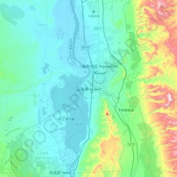
Name: Wuhai topographic map, elevation, terrain.
Average elevation: 4,108 ft
Minimum elevation: 3,484 ft
Maximum elevation: 7,044 ft
Make a donation
Gear up for your next adventure:
As an Amazon Associate, this site earns from qualifying purchases at no extra cost to you.
Other topographic maps
Click on a map to view its topography, its elevation and its terrain.
Baotou City
Baotou features a cold semi-arid climate (Köppen BSk), marked by long, cold and very dry winters, hot, somewhat humid summers, and strong winds, especially in spring. Temperatures often fall below −15 °C (5 °F) in winter and rise above 30 °C (86 °F) in summer. The annual precipitation is approximately…
Average elevation: 4,331 ft
Make a donation
Gear up for your next adventure:
As an Amazon Associate, this site earns from qualifying purchases at no extra cost to you.
Make a donation
Gear up for your next adventure:
As an Amazon Associate, this site earns from qualifying purchases at no extra cost to you.
Xilinhot City
The elevation of Xilinhot is approximately 990 m (3,250 ft). The city is 610 and 620 km (380 and 390 mi) from Beijing and Hohhot (the capital of Inner Mongolia), respectively.
Average elevation: 3,812 ft
Make a donation
Gear up for your next adventure:
As an Amazon Associate, this site earns from qualifying purchases at no extra cost to you.
Make a donation
Gear up for your next adventure:
As an Amazon Associate, this site earns from qualifying purchases at no extra cost to you.
Wuhai City
Wuhai is situated in western Inner Mongolia, in the upper reaches of the Yellow River, which flows through the city. The western bank of the river is Wuda District, while the eastern bank includes Haibowan District and Hainan District. The city borders Ordos City in Inner Mongolia to the east and north,…
Average elevation: 4,350 ft
Make a donation
Gear up for your next adventure:
As an Amazon Associate, this site earns from qualifying purchases at no extra cost to you.
Make a donation
Gear up for your next adventure:
As an Amazon Associate, this site earns from qualifying purchases at no extra cost to you.
Make a donation
Gear up for your next adventure:
As an Amazon Associate, this site earns from qualifying purchases at no extra cost to you.
Hailar District
Hailar is located in close proximity to the Greater Xing'an Mountains, and has an elevation ranging from 603.0 to 776.6 m (1,978.3 to 2,547.9 ft). Of the city's 1,319.8 square kilometers, 28 square kilometers (or 2.12%) of the district is urban.
Average elevation: 2,198 ft
Make a donation
Gear up for your next adventure:
As an Amazon Associate, this site earns from qualifying purchases at no extra cost to you.
Make a donation
Gear up for your next adventure:
As an Amazon Associate, this site earns from qualifying purchases at no extra cost to you.
Make a donation
Gear up for your next adventure:
As an Amazon Associate, this site earns from qualifying purchases at no extra cost to you.
Tongliao City
Tongliao's topography primarily consists of plains, though the northern stretch of the prefecture extends into the eastern foothills of the southern Greater Khingan. The central and eastern parts of the prefecture are marked by the plains of the Xiliao, Xinkai River (新开河), and Jiaolai rivers (教来河),…
Average elevation: 860 ft
Make a donation
Gear up for your next adventure:
As an Amazon Associate, this site earns from qualifying purchases at no extra cost to you.
Dorbod Banner
China > Inner Mongolia > Ulanqab City
The banner is located along the northern foothills of the Yin Mountains, and has an average elevation of 1,400 metres (4,600 ft).[3] Most of the banner's area is grassland.[3]
Average elevation: 4,245 ft
Make a donation
Gear up for your next adventure:
As an Amazon Associate, this site earns from qualifying purchases at no extra cost to you.