
Make a donation
Gear up for your next adventure:
As an Amazon Associate, this site earns from qualifying purchases at no extra cost to you.
La Florida topographic map
Click on the map to display elevation.
Make a donation
Gear up for your next adventure:
As an Amazon Associate, this site earns from qualifying purchases at no extra cost to you.
About this map
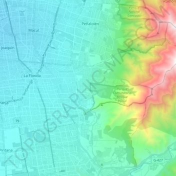
Name: La Florida topographic map, elevation, terrain.
Average elevation: 3,159 ft
Minimum elevation: 1,785 ft
Maximum elevation: 9,285 ft
Make a donation
Gear up for your next adventure:
As an Amazon Associate, this site earns from qualifying purchases at no extra cost to you.
Other topographic maps
Click on a map to view its topography, its elevation and its terrain.
Cerro San Cristóbal
Chile > Región Metropolitana de Santiago > Provincia de Santiago
El cerro San Cristóbal está ubicado en Santiago, Chile. Con una altitud de 880 m s. n. m. y una prominencia de 280 m, es el cuarto punto más alto de la ciudad, superado por los cerros Manquehue, Lo Aguirre y Renca. El cerro se encuentra entre las comunas de Providencia y Recoleta, y tiene a sus pies…
Average elevation: 2,018 ft
Santiago
Chile > Región Metropolitana de Santiago > Provincia de Santiago
Santiago se encuentra aproximadamente en las coordenadas 33°26′16″S 70°39′01″O / -33.43778, -70.65028 (a similar latitud que Ciudad del Cabo y Sydney) y a una altitud media de 567 msnm. Con una extensión de 837,89 km², Santiago contaba en 2017 con una población de 6 257 516 habitantes,…
Average elevation: 2,369 ft
Parque Metropolitano de Santiago
Chile > Región Metropolitana de Santiago > Provincia de Santiago > Providencia
Average elevation: 2,005 ft
Santuario de la Naturaleza Quebrada de la Plata
Chile > Región Metropolitana de Santiago > Provincia de Santiago
Average elevation: 2,572 ft
Make a donation
Gear up for your next adventure:
As an Amazon Associate, this site earns from qualifying purchases at no extra cost to you.
Santiago
Chile > Región Metropolitana de Santiago > Provincia de Santiago
Santiago se encuentra aproximadamente en las coordenadas 33°26′16″S 70°39′01″O / -33.43778, -70.65028 (a similar latitud que Ciudad del Cabo y Sydney) y a una altitud media de 567 msnm. Con una extensión de 837,89 km², Santiago contaba en 2017 con una población de 6 257 516 habitantes,…
Average elevation: 2,369 ft
Parque O'Higgins
Chile > Región Metropolitana de Santiago > Provincia de Santiago > Santiago
Average elevation: 1,759 ft
Parque Quinta Normal
Chile > Región Metropolitana de Santiago > Provincia de Santiago
Average elevation: 1,726 ft
Salto de Apoquindo
Chile > Región Metropolitana de Santiago > Provincia de Santiago
Average elevation: 5,771 ft
Make a donation
Gear up for your next adventure:
As an Amazon Associate, this site earns from qualifying purchases at no extra cost to you.
Santa Margarita
Chile > Región Metropolitana de Santiago > Provincia de Santiago
Average elevation: 1,476 ft
Farellones
Chile > Región Metropolitana de Santiago > Provincia de Santiago > Lo Barnechea
Farellones no solo se destaca por ser un centro de esquí, sino que además por los hallazgos arqueológicos efectuados en el cerro El Plomo. Desde antes de la creación de la villa de Farellones, este lugar era frecuentado por aventureros y arrieros en busca de antiguos tesoros incas, ya que era habitual…
Average elevation: 7,359 ft
Santuario de la Naturaleza Yerba Loca
Chile > Región Metropolitana de Santiago > Provincia de Santiago > Lo Barnechea
El área está caracterizada por una topografía de alta montaña con pendientes del orden de 15º a 30°, surcada por numerosas quebradas con escurrimientos hacia el poniente y vertientes de caras rugosas, cubiertas con material detrítico y escombros de falda. Las quebradas son relativamente profundas y…
Average elevation: 9,393 ft
Plaza San Luis
Chile > Región Metropolitana de Santiago > Provincia de Santiago
Average elevation: 1,768 ft
Make a donation
Gear up for your next adventure:
As an Amazon Associate, this site earns from qualifying purchases at no extra cost to you.
Plaza Villa Grecia
Chile > Región Metropolitana de Santiago > Provincia de Santiago > Pudahuel
Average elevation: 1,575 ft
Cerro Renca
Chile > Región Metropolitana de Santiago > Provincia de Santiago > Renca
Average elevation: 1,821 ft
Piscinas Antialuviones Quebrada de Macul
Chile > Región Metropolitana de Santiago > Provincia de Santiago
Average elevation: 3,015 ft
Parque La Platina
Chile > Región Metropolitana de Santiago > Provincia de Santiago
Average elevation: 2,077 ft
Make a donation
Gear up for your next adventure:
As an Amazon Associate, this site earns from qualifying purchases at no extra cost to you.
Parque de las Esculturas
Chile > Región Metropolitana de Santiago > Provincia de Santiago > Providencia
Average elevation: 2,073 ft
Ciudad de los Valles
Chile > Región Metropolitana de Santiago > Provincia de Santiago > Pudahuel
Average elevation: 1,778 ft
Parque San Borja
Chile > Región Metropolitana de Santiago > Provincia de Santiago > Santiago
Average elevation: 1,896 ft
Valle Nevado
Chile > Región Metropolitana de Santiago > Provincia de Santiago > Lo Barnechea
Debido a su elevación, Valle Nevado tiene un clima continental subalpino (Dsc según la clasificación climática de Köppen), con características mediterráneas (veranos secos) y una precipitación media anual de 488 mm. Los veranos son templados y secos, mientras que los inviernos son fríos y nevados.
Average elevation: 9,222 ft
Make a donation
Gear up for your next adventure:
As an Amazon Associate, this site earns from qualifying purchases at no extra cost to you.
Plaza Panamá
Chile > Región Metropolitana de Santiago > Provincia de Santiago > Santiago
Average elevation: 1,785 ft
Parque Titanium
Chile > Región Metropolitana de Santiago > Provincia de Santiago
Average elevation: 2,113 ft
Parque Bicentenario Cerrillos
Chile > Región Metropolitana de Santiago > Provincia de Santiago > Cerrillos
Average elevation: 1,686 ft
Mirador Cima
Chile > Región Metropolitana de Santiago > Provincia de Santiago > Renca
Average elevation: 1,824 ft
Make a donation
Gear up for your next adventure:
As an Amazon Associate, this site earns from qualifying purchases at no extra cost to you.
Cerro Manquehuito
Chile > Región Metropolitana de Santiago > Provincia de Santiago > Lo Barnechea
Average elevation: 3,458 ft
Cerro Provincia
Chile > Región Metropolitana de Santiago > Provincia de Santiago > Lo Barnechea
Tiene una altitud de 2750 m s. n. m. y limita al norte y oeste con el cerro Alto del Naranjo, al sur con el cerro la Cruz y al este con la cuenca de Vallecito. Este cerro es parte de la cadena montañosa sierra de Ramón, la que tiene por límites el río Mapocho por el Norte y el río Maipo por el Sur, la…
Average elevation: 7,710 ft
Cerro El Carbón
Chile > Región Metropolitana de Santiago > Provincia de Santiago > Huechuraba
El cerro El Carbón es una montaña que forma parte del cordón de Manquehue, en la Precordillera chilena de la Región Metropolitana de Santiago. Posee una altitud de 1365 m s. n. m., siendo el tercero más alto del cordón montañoso, luego del cerro Manquehue y El Peñón.
Average elevation: 3,100 ft
Cerro 18
Chile > Región Metropolitana de Santiago > Provincia de Santiago > Lo Barnechea
Average elevation: 2,930 ft
Make a donation
Gear up for your next adventure:
As an Amazon Associate, this site earns from qualifying purchases at no extra cost to you.
Plaza Italia
Chile > Región Metropolitana de Santiago > Provincia de Santiago > Providencia
Average elevation: 1,932 ft
Mina Los Bronces
Chile > Región Metropolitana de Santiago > Provincia de Santiago > Lo Barnechea
Average elevation: 12,047 ft
Cerro Primo de Rivera
Chile > Región Metropolitana de Santiago > Provincia de Santiago
Average elevation: 1,572 ft
Cerro Tarapacá
Chile > Región Metropolitana de Santiago > Provincia de Santiago > La Florida
Average elevation: 6,932 ft
Make a donation
Gear up for your next adventure:
As an Amazon Associate, this site earns from qualifying purchases at no extra cost to you.
Alto Hotel
Chile > Región Metropolitana de Santiago > Provincia de Santiago > Lo Barnechea
Average elevation: 9,157 ft
MIrador El Olivillo
Chile > Región Metropolitana de Santiago > Provincia de Santiago > Lo Barnechea
Average elevation: 7,756 ft
El Maitén
Chile > Región Metropolitana de Santiago > Provincia de Santiago
Average elevation: 1,480 ft
Parque Uruguay
Chile > Región Metropolitana de Santiago > Provincia de Santiago > Providencia
Average elevation: 2,080 ft
Make a donation
Gear up for your next adventure:
As an Amazon Associate, this site earns from qualifying purchases at no extra cost to you.
Quinta Normal
Chile > Región Metropolitana de Santiago > Provincia de Santiago > Quinta Normal
Average elevation: 1,736 ft
Parque de las Palmeras
Chile > Región Metropolitana de Santiago > Provincia de Santiago > Renca
Average elevation: 1,706 ft
Lomas de Lo Aguirre
Chile > Región Metropolitana de Santiago > Provincia de Santiago > Pudahuel
Average elevation: 1,778 ft
Jardín Mapulemu
Chile > Región Metropolitana de Santiago > Provincia de Santiago > Providencia
Average elevation: 2,080 ft
Make a donation
Gear up for your next adventure:
As an Amazon Associate, this site earns from qualifying purchases at no extra cost to you.
Estero La Leonera
Chile > Región Metropolitana de Santiago > Provincia de Santiago > Lo Barnechea
Average elevation: 10,968 ft
Plaza Padre Juan Rens Peeters
Chile > Región Metropolitana de Santiago > Provincia de Santiago
Average elevation: 1,903 ft
Parque Forestal
Chile > Región Metropolitana de Santiago > Provincia de Santiago > Santiago
Average elevation: 1,916 ft
Mirador Los Gemelos
Chile > Región Metropolitana de Santiago > Provincia de Santiago > Vitacura
Average elevation: 2,060 ft
Make a donation
Gear up for your next adventure:
As an Amazon Associate, this site earns from qualifying purchases at no extra cost to you.
Parque Intercomunal Padre Hurtado
Chile > Región Metropolitana de Santiago > Provincia de Santiago
Average elevation: 2,257 ft
Parque Bicentenario
Chile > Región Metropolitana de Santiago > Provincia de Santiago > Vitacura
Average elevation: 2,123 ft
El Colorado
Chile > Región Metropolitana de Santiago > Provincia de Santiago > Lo Barnechea
Average elevation: 8,632 ft
Cerro Primo de Rivera
Chile > Región Metropolitana de Santiago > Provincia de Santiago
Average elevation: 1,572 ft
Make a donation
Gear up for your next adventure:
As an Amazon Associate, this site earns from qualifying purchases at no extra cost to you.
Plaza Los Presidentes
Chile > Región Metropolitana de Santiago > Provincia de Santiago > Santiago
Average elevation: 1,962 ft
Cerro San Cristóbal
Chile > Región Metropolitana de Santiago > Provincia de Santiago
El cerro San Cristóbal está ubicado en Santiago, Chile. Con una altitud de 880 m s. n. m. y una prominencia de 280 m, es el cuarto punto más alto de la ciudad, superado por los cerros Manquehue, Lo Aguirre y Renca. El cerro se encuentra entre las comunas de Providencia y Recoleta, y tiene a sus pies…
Average elevation: 2,018 ft
Santiago
Chile > Región Metropolitana de Santiago > Provincia de Santiago
Santiago se encuentra aproximadamente en las coordenadas 33°26′16″S 70°39′01″O / -33.43778, -70.65028 (a similar latitud que Ciudad del Cabo y Sídney) y a una altitud media de 567 m s. n. m. Con una extensión de 837,89 km², Santiago contaba en 2017 con una población de 6 254 314…
Average elevation: 2,369 ft
Cerro El Plomo
Chile > Región Metropolitana de Santiago > Provincia de Santiago > Lo Barnechea
El cerro El Plomo es una montaña ubicada en la Región Metropolitana de Santiago. Con una altitud de 5424 m s. n. m., es el punto más alto visible desde la ciudad de Santiago de Chile.
Average elevation: 16,398 ft
Make a donation
Gear up for your next adventure:
As an Amazon Associate, this site earns from qualifying purchases at no extra cost to you.
Cerro Conchalí
Chile > Región Metropolitana de Santiago > Provincia de Santiago > Lo Barnechea
Average elevation: 7,329 ft
La Parva
Chile > Región Metropolitana de Santiago > Provincia de Santiago > Lo Barnechea
Average elevation: 9,288 ft
Cerro Ñipa
Chile > Región Metropolitana de Santiago > Provincia de Santiago > Lo Barnechea
Average elevation: 6,522 ft
Cerro Canoitas
Chile > Región Metropolitana de Santiago > Provincia de Santiago > Lo Barnechea
Average elevation: 7,438 ft
Make a donation
Gear up for your next adventure:
As an Amazon Associate, this site earns from qualifying purchases at no extra cost to you.
Alto del Naranjo
Chile > Región Metropolitana de Santiago > Provincia de Santiago > Lo Barnechea
El Alto del Naranjo es una meseta precordillerana de Los Andes, muy visitadas de la ciudad de Santiago[1]. Tiene una de altitud 1.890 msnm y se encuentra al noroeste del Cerro Provincia. Alto del Naranjo es parte de la cadena montañosa sierra de Ramón, la que tiene por límites el río Mapocho por el norte y…
Average elevation: 5,144 ft
Parque Urbano Bicentenario de la Infancia
Chile > Región Metropolitana de Santiago > Provincia de Santiago
Average elevation: 1,942 ft
Parque Santa Rosa de Apoquindo
Chile > Región Metropolitana de Santiago > Provincia de Santiago > Santiago
Average elevation: 2,385 ft
Parque de los Reyes
Chile > Región Metropolitana de Santiago > Provincia de Santiago > Santiago
Average elevation: 1,765 ft
Make a donation
Gear up for your next adventure:
As an Amazon Associate, this site earns from qualifying purchases at no extra cost to you.
Cerro Santa Lucía
Chile > Región Metropolitana de Santiago > Provincia de Santiago
El cerro Santa Lucía es un parque urbano ubicado en el corazón de la ciudad de Santiago de Chile. Limita al sur con la Avenida Libertador General Bernardo O'Higgins, donde se encuentra la estación Santa Lucía del Metro de Santiago, al oeste con la calle Santa Lucía, al norte con la calle Merced y al este…
Average elevation: 1,880 ft
Santiago
Chile > Región Metropolitana de Santiago > Provincia de Santiago
Santiago se encuentra aproximadamente en las coordenadas 33°26′16″S 70°39′01″O / -33.43778, -70.65028 (a similar latitud que Ciudad del Cabo y Sydney) y a una altitud media de 567 msnm. Con una extensión de 837,89 km², Santiago contaba en 2017 con una población de 6 257 516 habitantes,…
Average elevation: 2,369 ft
Parque de los Reyes
Chile > Región Metropolitana de Santiago > Provincia de Santiago > Quinta Normal
Average elevation: 1,765 ft
Parque Intercomunal Padre Hurtado
Chile > Región Metropolitana de Santiago > Provincia de Santiago
Average elevation: 2,257 ft
Make a donation
Gear up for your next adventure:
As an Amazon Associate, this site earns from qualifying purchases at no extra cost to you.
Cerro Manquehue
Chile > Región Metropolitana de Santiago > Provincia de Santiago > Vitacura
Average elevation: 3,881 ft
Farellones
Chile > Región Metropolitana de Santiago > Provincia de Santiago > Lo Barnechea
Farellones no solo se destaca por ser un centro de esquí, sino que además por los hallazgos arqueológicos efectuados en el cerro El Plomo. Desde antes de la creación de la villa de Farellones, este lugar era frecuentado por aventureros y arrieros en busca de antiguos tesoros incas, ya que era habitual…
Average elevation: 7,359 ft
Parque Metropolitano de Santiago
Chile > Región Metropolitana de Santiago > Provincia de Santiago > Providencia
Average elevation: 2,005 ft
Cerro Renca
Chile > Región Metropolitana de Santiago > Provincia de Santiago > Renca
Average elevation: 1,821 ft
Make a donation
Gear up for your next adventure:
As an Amazon Associate, this site earns from qualifying purchases at no extra cost to you.
Plazoleta Nueve de Marzo
Chile > Región Metropolitana de Santiago > Provincia de Santiago
Average elevation: 1,781 ft
Plaza Baquedano
Chile > Región Metropolitana de Santiago > Provincia de Santiago > Providencia
Average elevation: 1,932 ft
Cerro Polanco
Chile > Región Metropolitana de Santiago > Provincia de Santiago
Average elevation: 2,165 ft
Cerro San Cristóbal
Chile > Región Metropolitana de Santiago > Provincia de Santiago
El cerro San Cristóbal está ubicado en Santiago, Chile. Con una altitud de 880 m s. n. m. y una prominencia de 280 m, es el cuarto punto más alto de la ciudad, superado por los cerros Manquehue, Lo Aguirre y Renca. El cerro se encuentra entre las comunas de Providencia y Recoleta, y tiene a sus pies…
Average elevation: 2,018 ft
Make a donation
Gear up for your next adventure:
As an Amazon Associate, this site earns from qualifying purchases at no extra cost to you.
Parque Quinta Normal
Chile > Región Metropolitana de Santiago > Provincia de Santiago
Average elevation: 1,726 ft
Santiago
Chile > Región Metropolitana de Santiago > Provincia de Santiago
Santiago se encuentra aproximadamente en las coordenadas 33°26′16″S 70°39′01″O / -33.43778, -70.65028 (a similar latitud que Ciudad del Cabo y Sídney) y a una altitud media de 567 m s. n. m. Con una extensión de 837,89 km², Santiago contaba en 2017 con una población de 6 254 314…
Average elevation: 2,369 ft
Cerro Calán
Chile > Región Metropolitana de Santiago > Provincia de Santiago
Average elevation: 2,520 ft
Humedal El Pajonal
Chile > Región Metropolitana de Santiago > Provincia de Santiago
Average elevation: 1,614 ft
Make a donation
Gear up for your next adventure:
As an Amazon Associate, this site earns from qualifying purchases at no extra cost to you.
Cerro San Cristóbal
Chile > Región Metropolitana de Santiago > Provincia de Santiago
El cerro San Cristóbal está ubicado en Santiago, la capital de Chile. Con una altitud de 880 m s. n. m. y una prominencia de 280 m, es el cuarto punto más alto de la ciudad, superado por los cerros Manquehue, Lo Aguirre y Renca. El cerro se encuentra entre las comunas de Providencia y Recoleta, y…
Average elevation: 2,018 ft
Parque Inés de Suárez
Chile > Región Metropolitana de Santiago > Provincia de Santiago > Providencia
Average elevation: 1,952 ft
Cerro Santa Lucía
Chile > Región Metropolitana de Santiago > Provincia de Santiago > Santiago
El cerro Santa Lucía, antiguamente llamado cerro Huelén en picunche, es un parque urbano ubicado en el corazón de la ciudad de Santiago de Chile. Limita al sur con la Avenida Libertador General Bernardo O'Higgins, donde se encuentra la estación Santa Lucía del Metro de Santiago, al oeste con la calle…
Average elevation: 1,880 ft
Parque Mapocho Río Tramo 2
Chile > Región Metropolitana de Santiago > Provincia de Santiago > Quinta Normal
Average elevation: 1,647 ft
Make a donation
Gear up for your next adventure:
As an Amazon Associate, this site earns from qualifying purchases at no extra cost to you.
Valle Nevado
Chile > Región Metropolitana de Santiago > Provincia de Santiago > Lo Barnechea
Debido a su elevación, Valle Nevado tiene un clima continental subalpino (Dsc según la clasificación climática de Köppen), con características mediterráneas (veranos secos) y una precipitación media anual de 488 mm. Los veranos son fríos y secos, mientras que los inviernos son fríos y nevados.
Average elevation: 9,222 ft
Jardin Ermitaño Bajo
Chile > Región Metropolitana de Santiago > Provincia de Santiago
Average elevation: 1,969 ft
Parque Bicentenario
Chile > Región Metropolitana de Santiago > Provincia de Santiago > Vitacura
Average elevation: 2,123 ft
Parque La Quebrada de Macul
Chile > Región Metropolitana de Santiago > Provincia de Santiago > Santiago
Average elevation: 2,247 ft
Make a donation
Gear up for your next adventure:
As an Amazon Associate, this site earns from qualifying purchases at no extra cost to you.
Parque Urbano Bicentenario de la Infancia
Chile > Región Metropolitana de Santiago > Provincia de Santiago
Average elevation: 1,942 ft
Cerro Calán
Chile > Región Metropolitana de Santiago > Provincia de Santiago
Average elevation: 2,520 ft
Santiago
Chile > Región Metropolitana de Santiago > Provincia de Santiago
Santiago se encuentra aproximadamente en las coordenadas 33°26′16″S 70°39′01″O / -33.43778, -70.65028 (a similar latitud que Ciudad del Cabo y Sídney) y a una altitud media de 567 m s. n. m. Con una extensión de 837,89 km², Santiago contaba en 2017 con una población de 6 254 314…
Average elevation: 2,375 ft
Santiago
Chile > Región Metropolitana de Santiago > Provincia de Santiago
Santiago se encuentra aproximadamente en las coordenadas 33°26′16″S 70°39′01″O / -33.43778, -70.65028 (a similar latitud que Ciudad del Cabo y Sídney) y a una altitud media de 567 m s. n. m. Con una extensión de 837,89 km², Santiago contaba en 2017 con una población de 6 254 314…
Average elevation: 2,369 ft
Make a donation
Gear up for your next adventure:
As an Amazon Associate, this site earns from qualifying purchases at no extra cost to you.
Cerro Primo de Rivera
Chile > Región Metropolitana de Santiago > Provincia de Santiago
Average elevation: 1,572 ft
Cerro Santa Lucía
Chile > Región Metropolitana de Santiago > Provincia de Santiago
El cerro Santa Lucía, antiguamente llamado cerro Huelén en picunche, es un parque urbano ubicado en el corazón de la ciudad de Santiago de Chile. Limita al sur con la Avenida Libertador General Bernardo O'Higgins, donde se encuentra la estación Santa Lucía del Metro de Santiago, al oeste con la calle…
Average elevation: 1,880 ft
Parque San Borja
Chile > Región Metropolitana de Santiago > Provincia de Santiago > Santiago
Average elevation: 1,896 ft
Parque Metropolitano de Santiago
Chile > Región Metropolitana de Santiago > Provincia de Santiago > Providencia
Average elevation: 2,005 ft
Make a donation
Gear up for your next adventure:
As an Amazon Associate, this site earns from qualifying purchases at no extra cost to you.
Plaza Vicuña Mackenna
Chile > Región Metropolitana de Santiago > Provincia de Santiago > Santiago
Average elevation: 1,867 ft
Santiago
Chile > Región Metropolitana de Santiago > Provincia de Santiago
Santiago se encuentra aproximadamente en las coordenadas 33°26′16″S 70°39′01″O / -33.43778, -70.65028 (a similar latitud que Ciudad del Cabo y Sídney) y a una altitud media de 567 m s. n. m. Con una extensión de 837,89 km², Santiago contaba en 2017 con una población de 6 254 314…
Average elevation: 2,369 ft
Parque Inundable Víctor Jara
Chile > Región Metropolitana de Santiago > Provincia de Santiago
Average elevation: 1,749 ft
Parque Bicentenario
Chile > Región Metropolitana de Santiago > Provincia de Santiago > Vitacura
Average elevation: 2,123 ft
Make a donation
Gear up for your next adventure:
As an Amazon Associate, this site earns from qualifying purchases at no extra cost to you.
Cerro El Plomo
Chile > Región Metropolitana de Santiago > Provincia de Santiago > Lo Barnechea
El cerro El Plomo es una montaña ubicada en la Región Metropolitana de Santiago. Con una altitud de 5424 m s. n. m., es el punto más alto visible desde la ciudad de Santiago de Chile.
Average elevation: 16,398 ft
Parque Metropolitano de Santiago
Chile > Región Metropolitana de Santiago > Provincia de Santiago > Providencia
Average elevation: 2,005 ft
Morro Tambor
Chile > Región Metropolitana de Santiago > Provincia de Santiago > Lo Barnechea
Average elevation: 8,192 ft
Santiago
Chile > Región Metropolitana de Santiago > Provincia de Santiago
Santiago se encuentra aproximadamente en las coordenadas 33°26′16″S 70°39′01″O / -33.43778, -70.65028 (a similar latitud que Ciudad del Cabo y Sídney) y a una altitud media de 567 m s. n. m. Con una extensión de 837,89 km², Santiago contaba en 2017 con una población de 6 254 314…
Average elevation: 2,375 ft
Make a donation
Gear up for your next adventure:
As an Amazon Associate, this site earns from qualifying purchases at no extra cost to you.