
Make a donation
Gear up for your next adventure:
As an Amazon Associate, this site earns from qualifying purchases at no extra cost to you.
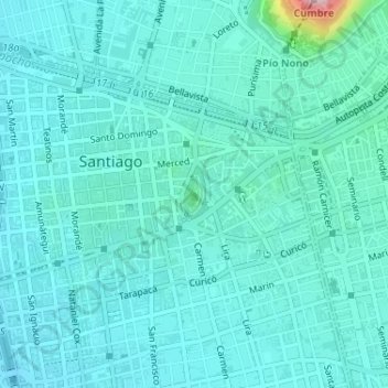
Cerro Santa Lucía topographic map
Click on the map to display elevation.
Make a donation
Gear up for your next adventure:
As an Amazon Associate, this site earns from qualifying purchases at no extra cost to you.
Cerro Santa Lucía
El cerro Santa Lucía, antiguamente llamado cerro Huelén en picunche, es un parque urbano ubicado en el corazón de la ciudad de Santiago de Chile. Limita al sur con la Avenida Libertador General Bernardo O'Higgins, donde se encuentra la estación Santa Lucía del Metro de Santiago, al oeste con la calle Santa Lucía, al norte con la calle Merced y al este con la calle Victoria Subercaseaux. Tiene una altitud de 629 m s. n. m., una altura de 68 m y una superficie de 65300 m².
Make a donation
Gear up for your next adventure:
As an Amazon Associate, this site earns from qualifying purchases at no extra cost to you.
About this map
Name: Cerro Santa Lucía topographic map, elevation, terrain.
Average elevation: 1,880 ft
Minimum elevation: 1,768 ft
Maximum elevation: 2,697 ft
Make a donation
Gear up for your next adventure:
As an Amazon Associate, this site earns from qualifying purchases at no extra cost to you.
Other topographic maps
Click on a map to view its topography, its elevation and its terrain.
Santiago
Chile > Región Metropolitana de Santiago > Provincia de Santiago
Santiago se encuentra aproximadamente en las coordenadas 33°26′16″S 70°39′01″O / -33.43778, -70.65028 (a similar latitud que Ciudad del Cabo y Sídney) y a una altitud media de 567 m s. n. m. Con una extensión de 837,89 km², Santiago contaba en 2017 con una población de 6 254 314…
Average elevation: 1,814 ft
Cerro San Cristóbal
Chile > Región Metropolitana de Santiago > Provincia de Santiago
El cerro San Cristóbal está ubicado en Santiago, Chile. Con una altitud de 880 m s. n. m. y una prominencia de 280 m, es el cuarto punto más alto de la ciudad, superado por los cerros Manquehue, Lo Aguirre y Renca. El cerro se encuentra entre las comunas de Providencia y Recoleta, y tiene a sus pies…
Average elevation: 2,018 ft
Santiago
Chile > Región Metropolitana de Santiago > Provincia de Santiago
Santiago se encuentra aproximadamente en las coordenadas 33°26′16″S 70°39′01″O / -33.43778, -70.65028 (a similar latitud que Ciudad del Cabo y Sydney) y a una altitud media de 567 msnm. Con una extensión de 837,89 km², Santiago contaba en 2017 con una población de 6 257 516 habitantes,…
Average elevation: 2,369 ft
Make a donation
Gear up for your next adventure:
As an Amazon Associate, this site earns from qualifying purchases at no extra cost to you.
Las Condes
Chile > Región Metropolitana de Santiago > Provincia de Santiago
Average elevation: 2,572 ft
Santiago
Chile > Región Metropolitana de Santiago > Provincia de Santiago
Santiago se encuentra aproximadamente en las coordenadas 33°26′16″S 70°39′01″O / -33.43778, -70.65028 (a similar latitud que Ciudad del Cabo y Sídney) y a una altitud media de 567 m s. n. m. Con una extensión de 837,89 km², Santiago contaba en 2017 con una población de 6 254 314…
Average elevation: 1,814 ft
Peñalolén
Chile > Región Metropolitana de Santiago > Provincia de Santiago
Al sur limita con la comuna de La Florida, el límite se extiende por la avenida Departamental desde avenida Américo Vespucio hasta la cima del Cerro San Ramón a una altitud de 3653 metros. En este punto limita además al oriente con la comuna de San José de Maipo.
Average elevation: 3,166 ft
Make a donation
Gear up for your next adventure:
As an Amazon Associate, this site earns from qualifying purchases at no extra cost to you.
Parque Bicentenario
Chile > Región Metropolitana de Santiago > Provincia de Santiago > Vitacura
Average elevation: 2,123 ft
Quilicura
Chile > Región Metropolitana de Santiago > Provincia de Santiago
La ciudad de Quilicura por ser parte de la Región Metropolitana de Santiago tiene las mismas características climáticas definidas para toda la zona central, con un clima mediterráneo, de temperaturas anuales de 13 °C y máximas arriba de los 30 °C en verano. La topografía del terreno es mayoritariamente…
Average elevation: 1,726 ft
La Florida
Chile > Región Metropolitana de Santiago > Provincia de Santiago
Average elevation: 3,159 ft
La Reina
Chile > Región Metropolitana de Santiago > Provincia de Santiago > Santiago
Average elevation: 2,835 ft
Make a donation
Gear up for your next adventure:
As an Amazon Associate, this site earns from qualifying purchases at no extra cost to you.
Salto de Apoquindo
Chile > Región Metropolitana de Santiago > Provincia de Santiago
Average elevation: 5,771 ft
Lo Barnechea
Chile > Región Metropolitana de Santiago > Provincia de Santiago
Estos patrones climáticos presentan, en esta comuna, variaciones muy importantes debido a su condición de área pie de monte, sometido al factor altitud. Se estima que en ambiente montañoso las lluvias aumentan en unos 22 mm cada 100 m de altitud, mientras que la temperatura disminuye en unos 0,5 °C cada…
Average elevation: 7,818 ft
Santa Margarita
Chile > Región Metropolitana de Santiago > Provincia de Santiago
Average elevation: 1,476 ft
Farellones
Chile > Región Metropolitana de Santiago > Provincia de Santiago > Lo Barnechea
Farellones no solo se destaca por ser un centro de esquí, sino que además por los hallazgos arqueológicos efectuados en el cerro El Plomo. Desde antes de la creación de la villa de Farellones, este lugar era frecuentado por aventureros y arrieros en busca de antiguos tesoros incas, ya que era habitual…
Average elevation: 7,359 ft
Make a donation
Gear up for your next adventure:
As an Amazon Associate, this site earns from qualifying purchases at no extra cost to you.
La Pintana
Chile > Región Metropolitana de Santiago > Provincia de Santiago
Average elevation: 2,070 ft
Providencia
Chile > Región Metropolitana de Santiago > Provincia de Santiago
Average elevation: 2,028 ft
Recoleta
Chile > Región Metropolitana de Santiago > Provincia de Santiago > Santiago
Average elevation: 1,883 ft
Quinta Normal
Chile > Región Metropolitana de Santiago > Provincia de Santiago
Quinta Normal se encuentra a una altitud promedio de 522 metros sobre el nivel del mar. En el límite comunal con Renca se emplaza el río Mapocho.
Average elevation: 1,683 ft
Make a donation
Gear up for your next adventure:
As an Amazon Associate, this site earns from qualifying purchases at no extra cost to you.
Las Condes
Chile > Región Metropolitana de Santiago > Provincia de Santiago
Average elevation: 2,572 ft
Cerro Renca
Chile > Región Metropolitana de Santiago > Provincia de Santiago > Renca
Average elevation: 1,821 ft
San Miguel
Chile > Región Metropolitana de Santiago > Provincia de Santiago > Santiago
Average elevation: 1,798 ft
San Ramón
Chile > Región Metropolitana de Santiago > Provincia de Santiago
Average elevation: 1,926 ft
Make a donation
Gear up for your next adventure:
As an Amazon Associate, this site earns from qualifying purchases at no extra cost to you.
La Cisterna
Chile > Región Metropolitana de Santiago > Provincia de Santiago
Average elevation: 1,857 ft
El Bosque
Chile > Región Metropolitana de Santiago > Provincia de Santiago
Average elevation: 1,923 ft
Cerro Navia
Chile > Región Metropolitana de Santiago > Provincia de Santiago
Average elevation: 1,608 ft
Estación Central
Chile > Región Metropolitana de Santiago > Provincia de Santiago
Average elevation: 1,693 ft
Make a donation
Gear up for your next adventure:
As an Amazon Associate, this site earns from qualifying purchases at no extra cost to you.
Huechuraba
Chile > Región Metropolitana de Santiago > Provincia de Santiago
Average elevation: 2,251 ft
Ciudad de los Valles
Chile > Región Metropolitana de Santiago > Provincia de Santiago > Pudahuel
Average elevation: 1,778 ft
Valle Nevado
Chile > Región Metropolitana de Santiago > Provincia de Santiago > Lo Barnechea
Debido a su elevación, Valle Nevado tiene un clima continental subalpino (Dsc según la clasificación climática de Köppen), con características mediterráneas (veranos secos) y una precipitación media anual de 488 mm. Los veranos son templados y secos, mientras que los inviernos son fríos y nevados.
Average elevation: 9,222 ft
Make a donation
Gear up for your next adventure:
As an Amazon Associate, this site earns from qualifying purchases at no extra cost to you.
Palacio de La Moneda
Chile > Región Metropolitana de Santiago > Provincia de Santiago > Santiago
Average elevation: 1,831 ft
Parque Forestal
Chile > Región Metropolitana de Santiago > Provincia de Santiago
Average elevation: 1,926 ft
Mirador Cima
Chile > Región Metropolitana de Santiago > Provincia de Santiago > Renca
Average elevation: 1,824 ft
Make a donation
Gear up for your next adventure:
As an Amazon Associate, this site earns from qualifying purchases at no extra cost to you.
Pedro Aguirre Cerda
Chile > Región Metropolitana de Santiago > Provincia de Santiago
Average elevation: 1,736 ft
Cerro Manquehuito
Chile > Región Metropolitana de Santiago > Provincia de Santiago > Lo Barnechea
Average elevation: 3,458 ft
Cerro Provincia
Chile > Región Metropolitana de Santiago > Provincia de Santiago > Lo Barnechea
Tiene una altitud de 2750 m s. n. m. y limita al norte y oeste con el cerro Alto del Naranjo, al sur con el cerro la Cruz y al este con la cuenca de Vallecito. Este cerro es parte de la cadena montañosa sierra de Ramón, la que tiene por límites el río Mapocho por el Norte y el río Maipo por el Sur, la…
Average elevation: 7,710 ft
Cerro El Carbón
Chile > Región Metropolitana de Santiago > Provincia de Santiago > Huechuraba
El cerro El Carbón es una montaña que forma parte del cordón de Manquehue, en la Precordillera chilena de la Región Metropolitana de Santiago. Posee una altitud de 1365 m s. n. m., siendo el tercero más alto del cordón montañoso, luego del cerro Manquehue y El Peñón.
Average elevation: 3,100 ft
Make a donation
Gear up for your next adventure:
As an Amazon Associate, this site earns from qualifying purchases at no extra cost to you.
Cerro 18
Chile > Región Metropolitana de Santiago > Provincia de Santiago > Lo Barnechea
Average elevation: 2,930 ft
Mina Los Bronces
Chile > Región Metropolitana de Santiago > Provincia de Santiago > Lo Barnechea
Average elevation: 12,047 ft
Independencia
Chile > Región Metropolitana de Santiago > Provincia de Santiago
Average elevation: 1,788 ft
Make a donation
Gear up for your next adventure:
As an Amazon Associate, this site earns from qualifying purchases at no extra cost to you.
Cerro Tarapacá
Chile > Región Metropolitana de Santiago > Provincia de Santiago > La Florida
Average elevation: 6,932 ft
Alto Hotel
Chile > Región Metropolitana de Santiago > Provincia de Santiago > Lo Barnechea
Average elevation: 9,157 ft
MIrador El Olivillo
Chile > Región Metropolitana de Santiago > Provincia de Santiago > Lo Barnechea
Average elevation: 7,756 ft
El Maitén
Chile > Región Metropolitana de Santiago > Provincia de Santiago
Average elevation: 1,480 ft
Make a donation
Gear up for your next adventure:
As an Amazon Associate, this site earns from qualifying purchases at no extra cost to you.
San Joaquín
Chile > Región Metropolitana de Santiago > Provincia de Santiago
Average elevation: 1,837 ft
Lomas de Lo Aguirre
Chile > Región Metropolitana de Santiago > Provincia de Santiago > Pudahuel
Average elevation: 1,778 ft
Cerrillos
Chile > Región Metropolitana de Santiago > Provincia de Santiago
Average elevation: 1,670 ft
Mirador Los Gemelos
Chile > Región Metropolitana de Santiago > Provincia de Santiago > Vitacura
Average elevation: 2,060 ft
Make a donation
Gear up for your next adventure:
As an Amazon Associate, this site earns from qualifying purchases at no extra cost to you.
Renca
Chile > Región Metropolitana de Santiago > Provincia de Santiago
En 2018, la cantidad de empresas registradas en Renca fue de 2.127. El Índice de Complejidad Económica (ECI) en el mismo año fue de 0,49, mientras que las actividades económicas con mayor índice de Ventaja Comparativa Revelada (RCA) fueron Actividades de Molienda de Arroz (75,2), Elaboración de Bebidas…
Average elevation: 1,647 ft
Maipú
Chile > Región Metropolitana de Santiago > Provincia de Santiago
Inaugurado el 13 de septiembre de 1910, este es el único monumento que responde a una orden directa de Bernardo O'Higgins. En la Gaceta Ministerial n.º 44 del sábado 13 de junio de 1818, O'Higgins y Zenteno decretaron: "En lo más descubierto de la loma, teatro principal de la batalla y de nuestros…
Average elevation: 1,654 ft
El Colorado
Chile > Región Metropolitana de Santiago > Provincia de Santiago > Lo Barnechea
Average elevation: 8,632 ft
Cerro Primo de Rivera
Chile > Región Metropolitana de Santiago > Provincia de Santiago
Average elevation: 1,572 ft
Make a donation
Gear up for your next adventure:
As an Amazon Associate, this site earns from qualifying purchases at no extra cost to you.
Lo Barnechea
Chile > Región Metropolitana de Santiago > Provincia de Santiago
Estos patrones climáticos presentan, en esta comuna, variaciones muy importantes debido a su condición de área pie de monte, sometido al factor altitud. Se estima que en ambiente montañoso las lluvias aumentan en unos 22 mm cada 100 m de altitud, mientras que la temperatura disminuye en unos 0,5 °C cada…
Average elevation: 7,818 ft
Cerro El Plomo
Chile > Región Metropolitana de Santiago > Provincia de Santiago > Lo Barnechea
El cerro El Plomo es una montaña ubicada en la Región Metropolitana de Santiago. Con una altitud de 5424 m s. n. m., es el punto más alto visible desde la ciudad de Santiago de Chile.
Average elevation: 16,398 ft
Make a donation
Gear up for your next adventure:
As an Amazon Associate, this site earns from qualifying purchases at no extra cost to you.
Cerro Conchalí
Chile > Región Metropolitana de Santiago > Provincia de Santiago > Lo Barnechea
Average elevation: 7,329 ft
Lo Espejo
Chile > Región Metropolitana de Santiago > Provincia de Santiago
Average elevation: 1,768 ft
Cerro San Cristóbal
Chile > Región Metropolitana de Santiago > Provincia de Santiago
El cerro San Cristóbal está ubicado en Santiago, Chile. Con una altitud de 880 m s. n. m. y una prominencia de 280 m, es el cuarto punto más alto de la ciudad, superado por los cerros Manquehue, Lo Aguirre y Renca. El cerro se encuentra entre las comunas de Providencia y Recoleta, y tiene a sus pies…
Average elevation: 2,018 ft
La Granja
Chile > Región Metropolitana de Santiago > Provincia de Santiago
Average elevation: 1,946 ft
Make a donation
Gear up for your next adventure:
As an Amazon Associate, this site earns from qualifying purchases at no extra cost to you.
La Parva
Chile > Región Metropolitana de Santiago > Provincia de Santiago > Lo Barnechea
Average elevation: 9,288 ft
Cerro Ñipa
Chile > Región Metropolitana de Santiago > Provincia de Santiago > Lo Barnechea
Average elevation: 6,522 ft
Cerro Canoitas
Chile > Región Metropolitana de Santiago > Provincia de Santiago > Lo Barnechea
Average elevation: 7,438 ft
Alto del Naranjo
Chile > Región Metropolitana de Santiago > Provincia de Santiago > Lo Barnechea
El Alto del Naranjo es una meseta precordillerana de Los Andes, muy visitadas de la ciudad de Santiago[1]. Tiene una de altitud 1.890 msnm y se encuentra al noroeste del Cerro Provincia. Alto del Naranjo es parte de la cadena montañosa sierra de Ramón, la que tiene por límites el río Mapocho por el norte y…
Average elevation: 5,144 ft
Make a donation
Gear up for your next adventure:
As an Amazon Associate, this site earns from qualifying purchases at no extra cost to you.
Santiago
Chile > Región Metropolitana de Santiago > Provincia de Santiago
Santiago se encuentra aproximadamente en las coordenadas 33°26′16″S 70°39′01″O / -33.43778, -70.65028 (a similar latitud que Ciudad del Cabo y Sídney) y a una altitud media de 567 m s. n. m. Con una extensión de 837,89 km², Santiago contaba en 2017 con una población de 6 254 314…
Average elevation: 2,369 ft
Quilicura
Chile > Región Metropolitana de Santiago > Provincia de Santiago
La ciudad de Quilicura por ser parte de la Región Metropolitana de Santiago tiene las mismas características climáticas definidas para toda la zona central, con un clima mediterráneo, de temperaturas anuales de 13 °C y máximas arriba de los 30 °C en verano. La topografía del terreno es mayoritariamente…
Average elevation: 1,726 ft
Quinta Normal
Chile > Región Metropolitana de Santiago > Provincia de Santiago
Average elevation: 1,683 ft
Maipú
Chile > Región Metropolitana de Santiago > Provincia de Santiago > Santiago
Inaugurado el 13 de septiembre de 1910, este es el único monumento que responde a una orden directa de Bernardo O'Higgins. En la Gaceta Ministerial n.º 44 del sábado 13 de junio de 1818, O'Higgins y Zenteno decretaron: "En lo más descubierto de la loma, teatro principal de la batalla y de nuestros…
Average elevation: 1,654 ft
Make a donation
Gear up for your next adventure:
As an Amazon Associate, this site earns from qualifying purchases at no extra cost to you.
Providencia
Chile > Región Metropolitana de Santiago > Provincia de Santiago
Average elevation: 2,028 ft
Río Mapocho
Chile > Región Metropolitana de Santiago > Provincia de Santiago
Average elevation: 1,932 ft
Cerrillos
Chile > Región Metropolitana de Santiago > Provincia de Santiago
Average elevation: 1,670 ft
Farellones
Chile > Región Metropolitana de Santiago > Provincia de Santiago > Lo Barnechea
Farellones no solo se destaca por ser un centro de esquí, sino que además por los hallazgos arqueológicos efectuados en el cerro El Plomo. Desde antes de la creación de la villa de Farellones, este lugar era frecuentado por aventureros y arrieros en busca de antiguos tesoros incas, ya que era habitual…
Average elevation: 7,359 ft
Make a donation
Gear up for your next adventure:
As an Amazon Associate, this site earns from qualifying purchases at no extra cost to you.
Santiago
Chile > Región Metropolitana de Santiago > Provincia de Santiago
Santiago se encuentra aproximadamente en las coordenadas 33°26′16″S 70°39′01″O / -33.43778, -70.65028 (a similar latitud que Ciudad del Cabo y Sydney) y a una altitud media de 567 msnm. Con una extensión de 837,89 km², Santiago contaba en 2017 con una población de 6 257 516 habitantes,…
Average elevation: 2,369 ft
Quilicura
Chile > Región Metropolitana de Santiago > Provincia de Santiago
La comuna de Quilicura se encuentra emplazada en la unidad geomorfológica de Cuenca de Santiago. La topografía del terreno es mayoritariamente llana, a ratos ondulada por ciertas lomas que pasan inadvertidas. La comuna está rodeada por varios cerros, como el Cerro Renca, lo que da una sensación de estar…
Average elevation: 1,729 ft
Make a donation
Gear up for your next adventure:
As an Amazon Associate, this site earns from qualifying purchases at no extra cost to you.
Santiago
Chile > Región Metropolitana de Santiago > Provincia de Santiago
Santiago se encuentra aproximadamente en las coordenadas 33°26′16″S 70°39′01″O / -33.43778, -70.65028 (a similar latitud que Ciudad del Cabo y Sídney) y a una altitud media de 567 m s. n. m. Con una extensión de 837,89 km², Santiago contaba en 2017 con una población de 6 254 314…
Average elevation: 1,814 ft
Cerro Manquehue
Chile > Región Metropolitana de Santiago > Provincia de Santiago > Vitacura
Average elevation: 3,881 ft
Las Condes
Chile > Región Metropolitana de Santiago > Provincia de Santiago > Santiago
Average elevation: 2,572 ft
Make a donation
Gear up for your next adventure:
As an Amazon Associate, this site earns from qualifying purchases at no extra cost to you.
Cerro Renca
Chile > Región Metropolitana de Santiago > Provincia de Santiago > Renca
Average elevation: 1,821 ft
Cerro Calán
Chile > Región Metropolitana de Santiago > Provincia de Santiago
Average elevation: 2,520 ft
Cerro San Cristóbal
Chile > Región Metropolitana de Santiago > Provincia de Santiago
El cerro San Cristóbal está ubicado en Santiago, la capital de Chile. Con una altitud de 880 m s. n. m. y una prominencia de 280 m, es el cuarto punto más alto de la ciudad, superado por los cerros Manquehue, Lo Aguirre y Renca. El cerro se encuentra entre las comunas de Providencia y Recoleta, y…
Average elevation: 2,018 ft
Recoleta
Chile > Región Metropolitana de Santiago > Provincia de Santiago > Santiago
Average elevation: 1,824 ft
Make a donation
Gear up for your next adventure:
As an Amazon Associate, this site earns from qualifying purchases at no extra cost to you.
Cerro Polanco
Chile > Región Metropolitana de Santiago > Provincia de Santiago
Average elevation: 2,165 ft
Cerro San Cristóbal
Chile > Región Metropolitana de Santiago > Provincia de Santiago
El cerro San Cristóbal está ubicado en Santiago, Chile. Con una altitud de 880 m s. n. m. y una prominencia de 280 m, es el cuarto punto más alto de la ciudad, superado por los cerros Manquehue, Lo Aguirre y Renca. El cerro se encuentra entre las comunas de Providencia y Recoleta, y tiene a sus pies…
Average elevation: 2,018 ft
Renca
Chile > Región Metropolitana de Santiago > Provincia de Santiago
En 2018, la cantidad de empresas registradas en Renca fue de 2.127. El Índice de Complejidad Económica (ECI) en el mismo año fue de 0,49, mientras que las actividades económicas con mayor índice de Ventaja Comparativa Revelada (RCA) fueron Actividades de Molienda de Arroz (75,2), Elaboración de Bebidas…
Average elevation: 1,647 ft
Make a donation
Gear up for your next adventure:
As an Amazon Associate, this site earns from qualifying purchases at no extra cost to you.
Santiago
Chile > Región Metropolitana de Santiago > Provincia de Santiago
Santiago se encuentra aproximadamente en las coordenadas 33°26′16″S 70°39′01″O / -33.43778, -70.65028 (a similar latitud que Ciudad del Cabo y Sídney) y a una altitud media de 567 m s. n. m. Con una extensión de 837,89 km², Santiago contaba en 2017 con una población de 6 254 314…
Average elevation: 2,369 ft
Barrio Italia
Chile > Región Metropolitana de Santiago > Provincia de Santiago > Providencia
Average elevation: 1,900 ft
Cerrillos
Chile > Región Metropolitana de Santiago > Provincia de Santiago
Average elevation: 1,670 ft
Make a donation
Gear up for your next adventure:
As an Amazon Associate, this site earns from qualifying purchases at no extra cost to you.
Valle Nevado
Chile > Región Metropolitana de Santiago > Provincia de Santiago > Lo Barnechea
Debido a su elevación, Valle Nevado tiene un clima continental subalpino (Dsc según la clasificación climática de Köppen), con características mediterráneas (veranos secos) y una precipitación media anual de 488 mm. Los veranos son fríos y secos, mientras que los inviernos son fríos y nevados.
Average elevation: 9,222 ft
Santiago
Chile > Región Metropolitana de Santiago > Provincia de Santiago
Santiago se encuentra aproximadamente en las coordenadas 33°26′16″S 70°39′01″O / -33.43778, -70.65028 (a similar latitud que Ciudad del Cabo y Sídney) y a una altitud media de 567 m s. n. m. Con una extensión de 837,89 km², Santiago contaba en 2017 con una población de 6 254 314…
Average elevation: 1,814 ft
La Florida
Chile > Región Metropolitana de Santiago > Provincia de Santiago > Santiago
Average elevation: 2,129 ft
Cerro Calán
Chile > Región Metropolitana de Santiago > Provincia de Santiago
Average elevation: 2,520 ft
Make a donation
Gear up for your next adventure:
As an Amazon Associate, this site earns from qualifying purchases at no extra cost to you.