
舟曲县 topographic map
Interactive map
Click on the map to display elevation.
About this map
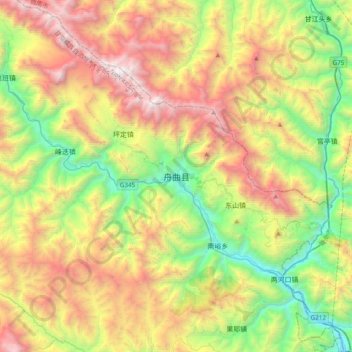
Name: 舟曲县 topographic map, elevation, terrain.
Location: 舟曲县, 甘南藏族自治州, 甘肃省, 746300, 中国 (33.62672 104.20872 33.94672 104.52872)
Average elevation: 7,838 ft
Minimum elevation: 3,878 ft
Maximum elevation: 13,547 ft
海拔高度在1173-4504米之间;地势西北高,东南低。白龙江谷地海拔较低,高度在1200米左右,南北两则的山地高峰可达4000米以上,中部山势较缓,海拔在3000米左右,为典型的高山峡谷区。
Other topographic maps
Click on a map to view its topography, its elevation and its terrain.