
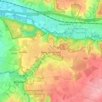
Berg en Terblijt topographic map
Interactive map
Click on the map to display elevation.
About this map
Name: Berg en Terblijt topographic map, elevation, terrain.
Location: Berg en Terblijt, Valkenburg aan de Geul, Limburg, Nederland (50.84835 5.74929 50.87320 5.81983)
Average elevation: 341 ft
Minimum elevation: 157 ft
Maximum elevation: 531 ft
Other topographic maps
Click on a map to view its topography, its elevation and its terrain.
Sint-Maartensberg
Nederland > Limburg > Plasmolen
De Nederrijnse Heuvelrug (Duits: Niederrheinischer Höhenzug) is een stuwwal, die zich met verschillende onderbrekingen in het westen van het Nederrijnse Laagvlakte van Krefeld tot Nijmegen in een wijde boog tussen het Rijndal in het oosten en het dal van de Niers uitstrekt. Dit landschapelement wordt ook wel…
Average elevation: 105 ft
Itteren
Nederland > Limburg > Maastricht
Itteren ligt op de rechteroever van de Maas, op een hoogte van ongeveer 43 meter. Het ligt sinds de aanleg van het Julianakanaal omstreeks 1930 op een langgerekt eiland, door enkele bruggen met het achterland verbonden.
Average elevation: 151 ft
Maas
Nederland > Limburg > Maastricht > Borgharen
Er is dan ook vaak hoogwater op de Maas. Het hoogste waterpeil van de afgelopen eeuwen bereikte de rivier tijdens de overstroming van januari 1643, waarbij grote verwoestingen werden aangericht en honderden doden te betreuren waren. Door de verbreding en verdieping van de Maas (vanaf 1840) werd het water…
Average elevation: 161 ft
Rijckholt
Rijckholt ligt in het Maasdal op een hoogte van ongeveer 52 meter. De omgeving wordt beheerst door boomgaarden en landbouw. Ten oosten van Rijckholt ligt de helling naar het Plateau van Margraten, met op deze helling het Savelsbos, een belangrijk natuurgebied. Ten westen van Rijckholt ligt het tracé van de…
Average elevation: 262 ft
Boekend
Boekend ligt op een hoogte van ongeveer 22 meter, in het laagterras van de Maas. Het Koelbroek is een nat natuurgebied dat zich ten noordwesten van Boekend bevindt, langs de Everlose Beek, die in feite een oude Maasmeander volgt. Verder naar het noordwesten ligt een zandige streek, met de voormalige Blerickse…
Average elevation: 79 ft
Houthem
Nederland > Limburg > Valkenburg
Houthem ligt in de vallei van de Geul, aan de rechteroever, op een hoogte van ongeveer 60 meter. In de omgeving van Houthem liggen diverse hellingbossen (waaronder op de noordhelling van het Geuldal het Kloosterbosch) en in het Geuldal het natuurontwikkelingsgebied Ingendael.
Average elevation: 344 ft
Lage Fronten
Nederland > Limburg > Maastricht
De kazemat aan de zuidwestzijde van ravelijn a diende na de opheffing van de vesting onder andere als woning voor de opzichter van de gemeentelijke vuilnisbelt en als gemeentelijke wintertuin voor planten. Later werden de gemeentelijk ophaalkarren van fecaliën hier geleegd. De kazemat kon in 1953 bij de…
Average elevation: 187 ft
Rimburg
Nederland > Limburg > Landgraaf
Rimburg is een langgerekt dorp dat parallel verloopt aan de Worm, die hier de grensrivier met Duitsland vormt. De hoogte van het dorp is ongeveer 95 meter. Op de hellingen van het plateau naar het dal liggen enkele hellingbossen, zoals het Rimburgerbos, waarin zich ook de watertoren en de Sint-Jozefkapel…
Average elevation: 381 ft
Kasen
Kasen (Limburgs: Kaze) is een landelijke buurtschap in de gemeente Meerssen in Nederlands Limburg. Kasen ligt zes kilometer ten noordoosten van Maastricht en twee kilometer ten noordoosten van Bunde op het plateau van de Kruisberg (plaatselijk ook bekend als Dennenberg), op 112 meter hoogte tussen het…
Average elevation: 266 ft
Berg
Nederland > Limburg > Berg en Terblijt
Berg is gelegen op de rand van het Plateau van Margraten op een hoogte van ongeveer 120 meter. Aan de noordelijke zijde liggen steile hellingen naar het Geuldal. Hier vindt men het natuurgebied Bergse Heide, met de voormalige Meertensgroeve en Langen Akker. Ten zuidoosten van de kern ligt de voormalige Groeve…
Average elevation: 325 ft
Holset
Het dorp ligt in het Selzerbeekdal op een lage heuvelrug die zich uitstrekt vanaf het ten zuiden van het dorp gelegen Vijlenerbos tot aan Lemiers, waarbij de heuvelrug geleidelijk aan steeds verder afloopt. Deze heuvelrug scheidt de ten westen van het dorp gelegen Hermansbeek van de ten oosten gelegen…
Average elevation: 682 ft
Tungelroy
Tungelroy is gelegen op een hoogte van ongeveer 31 meter op zandgrond. Een belangrijk deel van het grondgebied wordt door de landbouw ingenomen. Ten zuiden van Tungelroy stroomt de Tungelroyse Beek die een bodemsanering en een herinrichting heeft ondergaan (afgerond in 2007). Een belangrijk natuurgebied is de…
Average elevation: 105 ft
Camerig
Camerig ligt aan de rand van het Vijlenerbos op een hoogte van circa 160-180 meter boven NAP. Vanuit deze plek heeft men een goed uitzicht over het Geuldal, de oostelijke Ardennen en het noorden van de Eifel. Bij Camerig mondden verschillende beken uit in de Geul, van zuid naar noord de Belleterbeek,…
Average elevation: 545 ft
Eyserhalte
Bij Eyserhalte bevindt zich ter hoogte van Eyserlinde het verzetsmonument.
Average elevation: 453 ft
Nijswiller
Nijswiller ligt in het Selzerbeekdal, op een hoogte van ongeveer 120 meter. In het noordoosten ligt het Plateau van Bocholtz met het Kolmonderbosch en het Platte Bosch. In het zuidwesten ligt het Plateau van Vaals. Door het dorp stroomt de Selzerbeek.
Average elevation: 499 ft
Houthem
Nederland > Limburg > Valkenburg
Houthem ligt in de vallei van de Geul, aan de rechteroever, op een hoogte van ongeveer 60 meter. In de omgeving van Houthem liggen diverse hellingbossen (waaronder op de noordhelling van het Geuldal het Kloosterbosch) en in het Geuldal het natuurontwikkelingsgebied Ingendael.
Average elevation: 344 ft
Schinnen
Nederland > Limburg > Schinnen
Schinnen ligt in het dal van de Geleenbeek, waar die samenkomt met het dal van de Kakkert. Het dorp bevindt zich tegen de helling van een uitloper van het Plateau van Doenrade en de kerk ligt op ongeveer 75 meter hoogte. Deze uitloper staat bekend als de Moutheuvel. Enkele wegen vormen hier de oude toegang…
Average elevation: 302 ft
Rothem
Naar Rothem is het Rothem Terras (of Terras van Rothem) genoemd. Dit is een rivierterras dat gevormd is door de Maas tijdens het Midden Pleistoceen. Het Rothem Terras is een oude alluviale vlakte waarvan de bovenkant van de rivierafzettingen ter hoogte van Maastricht op ongeveer 81,5 meter boven NAP ligt. De…
Average elevation: 203 ft
Mamelis
Mamelis ligt in het Selzerbeekdal op een hoogte van ongeveer 130 meter. Langs Mamelis stroomt de Selzerbeek die naar het oosten toe de Nederlands-Duitse grens vormt. De beek heeft naar alle waarschijnlijkheid een belangrijke rol gespeeld bij het ontstaan en de ontwikkeling van Mamelis. De beek vormt de…
Average elevation: 554 ft