
Make a donation
Gear up for your next adventure:
As an Amazon Associate, this site earns from qualifying purchases at no extra cost to you.
Littleton topographic map
Click on the map to display elevation.
Make a donation
Gear up for your next adventure:
As an Amazon Associate, this site earns from qualifying purchases at no extra cost to you.
About this map
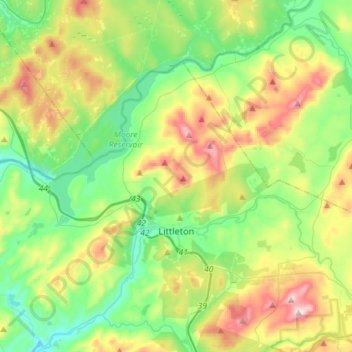
Name: Littleton topographic map, elevation, terrain.
Average elevation: 1,181 ft
Minimum elevation: 577 ft
Maximum elevation: 2,388 ft
Grafton County trails, hiking, mountain biking, running and outdoor activities
Make a donation
Gear up for your next adventure:
As an Amazon Associate, this site earns from qualifying purchases at no extra cost to you.
Other topographic maps
Click on a map to view its topography, its elevation and its terrain.
Stinson Lake
United States > New Hampshire > Grafton County > Rumney > Stinson Lake
Average elevation: 1,509 ft
Make a donation
Gear up for your next adventure:
As an Amazon Associate, this site earns from qualifying purchases at no extra cost to you.
Make a donation
Gear up for your next adventure:
As an Amazon Associate, this site earns from qualifying purchases at no extra cost to you.
Middle Sugarloaf
United States > New Hampshire > Grafton County > Bethlehem
Average elevation: 1,942 ft
Make a donation
Gear up for your next adventure:
As an Amazon Associate, this site earns from qualifying purchases at no extra cost to you.
Campton Hollow
United States > New Hampshire > Grafton County > Campton > Campton Hollow
Average elevation: 823 ft
Make a donation
Gear up for your next adventure:
As an Amazon Associate, this site earns from qualifying purchases at no extra cost to you.
Corcoran Pond
United States > New Hampshire > Grafton County > Waterville Valley
Average elevation: 1,713 ft
Waterville Valley
United States > New Hampshire > Grafton County > Waterville Valley > Waterville Valley
Average elevation: 1,860 ft
Make a donation
Gear up for your next adventure:
As an Amazon Associate, this site earns from qualifying purchases at no extra cost to you.
Make a donation
Gear up for your next adventure:
As an Amazon Associate, this site earns from qualifying purchases at no extra cost to you.
Downing Mountain
United States > New Hampshire > Grafton County > Ellsworth
Average elevation: 1,460 ft
Make a donation
Gear up for your next adventure:
As an Amazon Associate, this site earns from qualifying purchases at no extra cost to you.
Campton Lower Village
United States > New Hampshire > Grafton County > Campton
Average elevation: 853 ft
Mount Pemigewasset
United States > New Hampshire > Grafton County > Lincoln
Average elevation: 1,995 ft
Make a donation
Gear up for your next adventure:
As an Amazon Associate, this site earns from qualifying purchases at no extra cost to you.
Woodstock
United States > New Hampshire > Grafton County > Woodstock > Woodstock
Average elevation: 1,093 ft
Make a donation
Gear up for your next adventure:
As an Amazon Associate, this site earns from qualifying purchases at no extra cost to you.