
Make a donation
Gear up for your next adventure:
As an Amazon Associate, this site earns from qualifying purchases at no extra cost to you.
Meadow Brook topographic map
Click on the map to display elevation.
Make a donation
Gear up for your next adventure:
As an Amazon Associate, this site earns from qualifying purchases at no extra cost to you.
About this map
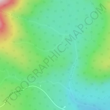
Name: Meadow Brook topographic map, elevation, terrain.
Average elevation: 1,864 ft
Minimum elevation: 1,460 ft
Maximum elevation: 2,884 ft
Grafton County trails, hiking, mountain biking, running and outdoor activities
Make a donation
Gear up for your next adventure:
As an Amazon Associate, this site earns from qualifying purchases at no extra cost to you.
Other topographic maps
Click on a map to view its topography, its elevation and its terrain.
Make a donation
Gear up for your next adventure:
As an Amazon Associate, this site earns from qualifying purchases at no extra cost to you.
Make a donation
Gear up for your next adventure:
As an Amazon Associate, this site earns from qualifying purchases at no extra cost to you.
Holderness
United States > New Hampshire > Grafton County
According to the United States Census Bureau, the town has a total area of 35.7 square miles (92.5 km2), of which 30.3 square miles (78.6 km2) are land and 5.4 square miles (13.9 km2) are water, comprising 15.05% of the town. Bounded on the northwest by the Pemigewasset River, Holderness is drained by Owl…
Average elevation: 827 ft
Make a donation
Gear up for your next adventure:
As an Amazon Associate, this site earns from qualifying purchases at no extra cost to you.
Middle Sugarloaf
United States > New Hampshire > Grafton County > Bethlehem
Average elevation: 1,942 ft
Make a donation
Gear up for your next adventure:
As an Amazon Associate, this site earns from qualifying purchases at no extra cost to you.
Bristol
United States > New Hampshire > Grafton County
According to the United States Census Bureau, the town has a total area of 21.9 square miles (56.8 km2), of which 16.8 square miles (43.4 km2) are land and 5.2 square miles (13.4 km2) are water, comprising 23.60% of the town. Bristol is drained by the Pemigewasset River (forming the southeastern boundary of…
Average elevation: 833 ft
Dorchester
United States > New Hampshire > Grafton County
According to the United States Census Bureau, the town has a total area of 45.2 square miles (117.1 km2), of which 44.6 square miles (115.5 km2) are land and 0.62 square miles (1.6 km2) are water, comprising 1.34% of the town. It is drained by the north-flowing South Branch Baker River and the south-flowing…
Average elevation: 1,440 ft
Enfield
United States > New Hampshire > Grafton County
According to the United States Census Bureau, the town has a total area of 43.1 square miles (111.6 km2), of which 40.3 sq mi (104.3 km2) is land and 2.9 sq mi (7.4 km2) is water, comprising 6.59% of the town. Enfield is drained by the Mascoma River. Mascoma Lake, in the west, represents Enfield's lowest…
Average elevation: 1,201 ft
Make a donation
Gear up for your next adventure:
As an Amazon Associate, this site earns from qualifying purchases at no extra cost to you.
Hebron
United States > New Hampshire > Grafton County
Hebron sits at the north end of Newfound Lake, the fourth-largest lake in New Hampshire. The Cockermouth River, the primary feeder to the lake, enters the town from Groton to the west and passes the town center before entering the lake. Hebron lies fully within the Merrimack River watershed. The highest point…
Average elevation: 1,073 ft
Make a donation
Gear up for your next adventure:
As an Amazon Associate, this site earns from qualifying purchases at no extra cost to you.
Campton Lower Village
United States > New Hampshire > Grafton County > Campton
Average elevation: 853 ft
Mount Pemigewasset
United States > New Hampshire > Grafton County > Lincoln
Average elevation: 1,995 ft
Make a donation
Gear up for your next adventure:
As an Amazon Associate, this site earns from qualifying purchases at no extra cost to you.
Make a donation
Gear up for your next adventure:
As an Amazon Associate, this site earns from qualifying purchases at no extra cost to you.
Campton Hollow
United States > New Hampshire > Grafton County > Campton > Campton Hollow
Average elevation: 823 ft
Woodstock
United States > New Hampshire > Grafton County > Woodstock > Woodstock
Average elevation: 1,093 ft
Make a donation
Gear up for your next adventure:
As an Amazon Associate, this site earns from qualifying purchases at no extra cost to you.
Make a donation
Gear up for your next adventure:
As an Amazon Associate, this site earns from qualifying purchases at no extra cost to you.
Waterville Valley
United States > New Hampshire > Grafton County > Waterville Valley > Waterville Valley
Average elevation: 1,860 ft
Make a donation
Gear up for your next adventure:
As an Amazon Associate, this site earns from qualifying purchases at no extra cost to you.
Downing Mountain
United States > New Hampshire > Grafton County > Ellsworth
Average elevation: 1,460 ft